15 Canyonlands Hikes That Will Take Your Breath Away
Canyonland Hikes: Are you looking for the best hikes in Canyonlands National Park? Hiking in Canyonlands is one of the best ways to see the park and take in the views.
I’ve included easy, family friendly hikes on this list of Canyonlands Hikes. Hiking in Canyonlands is one of the top things to do so I wanted to make it accessible to everyone.
Thank you for supporting this website written by an American. This post may contain affiliate links. This means I earn a small commission on these links at no extra cost to you.
National Park Entrance Fees
To enter the National Parks, you’ll need to pay an entrance fee or have a National Parks Pass also known as American the Beautiful Pass.
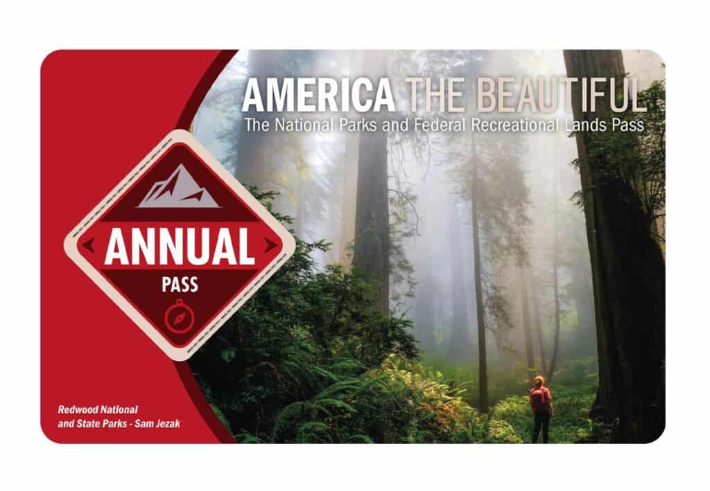
It costs $80 for a yearly America the Beautiful Pass. This gives you access to all national parks and federal areas that charge fees. The America the Beautiful Pass is well worth it!
I purchased my first one in 2016 and it’s such a money-saver! Plus 10% of sale proceeds go to the National Park Foundation.
Tips for Visiting Grand Teton National Park
Grand Canyon National Park is perfect for outdoor enthusiasts. There is something for everyone on this list and for different fitness levels. Also, note that it is dry and hot (in the summer), and make sure you know what you are getting into before you start. Here are a few tips for visiting the Grand Canyon:
- Bring a reusable water bottle and lots of water! Remember you are in the sun and you will need to drink lots of water. I love my LifeStraw Filtered Water Bottle. I can refill this bottle anywhere and it comes with a carabiner to connect it to my daypack.
- Check the Weather – days over 100 degrees are very common. Make sure to check.
- Hiking boots or sandals that will protect your feet! I love good shoes. I need all the support and help I can get. I actually love these sandals for hiking and also love these hiking boots.
- Bring hiking poles for balance and to protect your knees. I know many experienced hikers (and even amateur ones) think that hiking poles are for old people who lose their balance. Actually, hiking poles can help when going down steep inclines or when scrambling over rocks. They are great to hike with even for the most experienced hiker.
- Wear a sunhat. I feel like this whole post is about how high you are in the mountains and how much closer you are to the sun but it is so true. At elevation, you are closer to the sun and more likely to burn. Wear sun protection such as a sun hat and sunscreen.
- Be aware of the wildlife. This is the Southwest and you will need to watch out for snakes and other wildlife such as moose or a bear. Please stay away from wildlife and do not feed them. I recommend carrying bear spray as well.
- Start Early – If you want to avoid the traffic and the heat you will need to start your hike early. That way it will be nice and cool and the smog will not affect you either.
- Leave no trace. If you are new to the concept of Leave No Trace it is all about preserving the environment to ensure it is in the same or better condition when you leave it. This means that you should stick to the trails and carry out everything that you carried in. This is a great explanation of the Leave No Trace principles!
- Water shoes are great for water hikes– If you don’t have a pair, I highly suggest it as they are affordable. I have an article on the pros and cons of several pairs of water shoes.
- Bring Bug Spray and a snack: Be sure to bring everything you need including a snack like a protein bar plus BUG SPRAY.
Where to stay near Grand Canyon National Park
The Grand Canyon makes for a great weekend escape. Fresh air, beautiful scenery and being in nature does a world of good for the soul. I recommend staying as close to the park as possible and even treating yourself with a cabin with a spa pool to relax at night.
- There are lots of fantastic Airbnbs near the Grand Canyon. I have made a list of the best airbnbs around the park wherever you decide to stay. You can also check out my post on Where to Stay near the Grand Canyon to find the perfect hotel for any budget.
If you are taking a road trip remember to reserve a car in advance using Discover Cars .
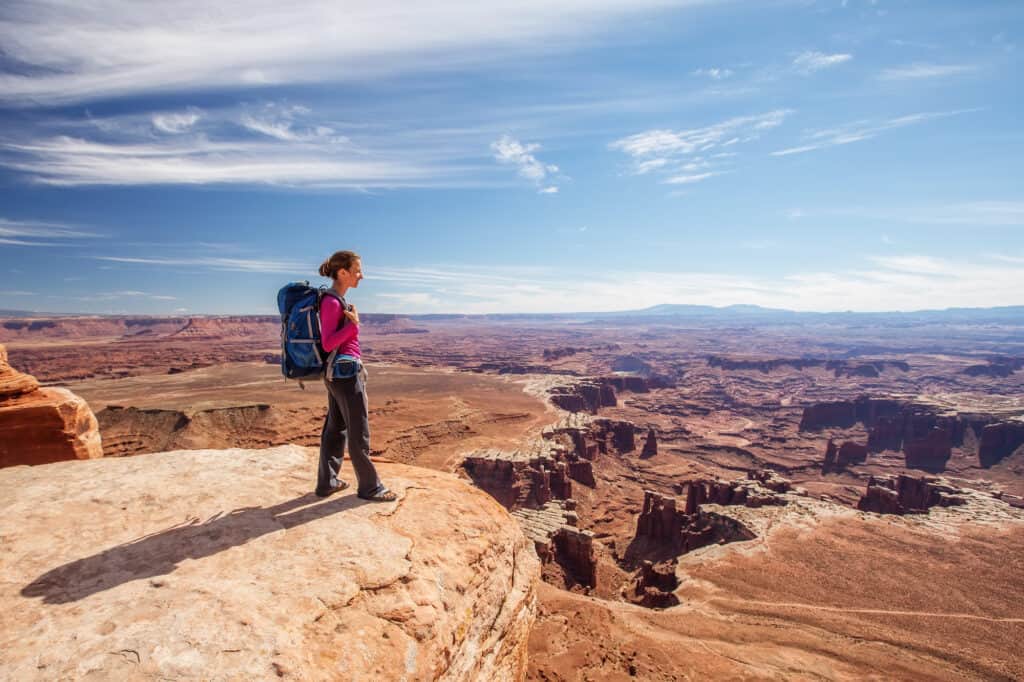
Tips for Visiting in Canyonlands National Park
Canyonlands is perfect for outdoor enthusiasts. There is something for everyone on this list and for different fitness levels. Also, note that it is dry and hot (in the summer), and make sure you know what you are getting into before you start. Here are a few tips for visiting Canyonlands:
- Bring a reusable water bottle and lots of water! Remember you are in the sun and you will need to drink lots of water. I love my LifeStraw Filtered Water Bottle. I can refill this bottle anywhere and it comes with a carabiner to connect it to my daypack.
- Check the Weather – days over 100 degrees are very common. Make sure to check.
- Hiking boots or sandals that will protect your feet! I love good shoes. I need all the support and help I can get. I actually love these sandals for hiking and also love these hiking boots.
- Bring hiking poles for balance and to protect your knees. I know many experienced hikers (and even amateur ones) think that hiking poles are for old people who lose their balance. Actually, hiking poles can help when going down steep inclines or when scrambling over rocks. They are great to hike with even for the most experienced hiker.
- Wear a sunhat. I feel like this whole post is about how high you are in the mountains and how much closer you are to the sun but it is so true. At elevation, you are closer to the sun and more likely to burn. Wear sun protection such as a sun hat and sunscreen.
- Be aware of the wildlife. This is the Southwest and you will need to watch out for snakes and other wildlife such as moose or a bear. Please stay away from wildlife and do not feed them. I recommend carrying bear spray as well.
- Start Early – If you want to avoid the traffic and the heat you will need to start your hike early. That way it will be nice and cool and the smog will not affect you either.
- Leave no trace. If you are new to the concept of Leave No Trace it is all about preserving the environment to ensure it is in the same or better condition when you leave it. This means that you should stick to the trails and carry out everything that you carried in. This is a great explanation of the Leave No Trace principles!
- Water shoes are great for water hikes– If you don’t have a pair, I highly suggest it as they are affordable. I have an article on the pros and cons of several pairs of water shoes.
- Bring Bug Spray and a snack: Be sure to bring everything you need including a snack like a protein bar plus BUG SPRAY.
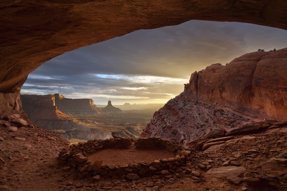
Overview of Canyonlands and the Four Districts of this National Park
These are the four districts of Canyonlands National Park. Most people Visit Island in the Sky because the entrance is closest to Moab, Utah and across the highway from Arches National Park.
Island in the Sky
Canyonlands National Park’s most visited part is this one. The Island in the Sky sector provides tourists with a wonderful perspective of the park, with spectacular viewpoints and a nice combination of simple and tough hiking paths.
On high sandstone cliffs, the Island in the Sky mesa rises 1,000 feet (304 meters) above the surrounding area. Every overlook offers a different perspective on Canyonlands’ magnificent scenery. Island in the Sky, which has many pullouts with excellent views along the paved scenic path, is the simplest portion of Canyonlands to tour in a short amount of time. Hiking trails and four-wheel-drive roads can whisk you away for a few hours or several days into the countryside.
This is also the most accessible. It’s also close to Moab and the Arches National Park. This area is perfect for driving tours and short hikes if you just have a limited amount of time. The scenic route also leads to some of the park’s most popular attractions.
The Needles
The Needles is just around the corner from Island in the Sky. Landscapes with unusually sculpted sandstone rock formations are breathtaking. Great treks, more spectacular vistas, and a break from the people who swarm Island in the Sky may all be found here.
The Needles district has a distinct appearance. The Needles’ heart is made up of zebra-striped sandstone spires that mimic the hoodoos of Bryce Canyon. Hiking paths weave their way between the needles, creating this is the Canyonlands’ best hiking spot.
The park’s main trail is less than 7 miles long and takes less than 10 minutes to complete. There are dirt and gravel roads off of this big, paved road. Some of these dirt roads are accessible by conventional cars, while others necessitate the use of a 4×4 and/or a permit. The Needles are 75 miles from Moab and take around an hour and a half to reach. The distance and time required to traverse this route deter the majority of people.
This section of Canyonlands National Park looks very different from the Island in the Sky district, with its wide collection of red and orange sandstone spires. The Needles should be on your bucket list if you enjoy hiking, backpacking, or exploring new places. This part of the park can be visited in a single day.
The Maze
The Maze is a remote Canyonlands area that can only be reached by 4WD. Backcountry experience and self-sufficiency are required to explore this section of the park.
The Maze Canyons are 3 to 6 hours away from the ranger station by high-clearance, 4WD vehicle (more if traveling by foot). Another four-wheel-drive road extends north from Highway 95 near Hite Marina into the Maze.
Because of the district’s isolation and the difficulty of the roads and paths, getting to the Maze takes longer. Visitors must be self-sufficient and equipped to self-rescue. The Maze is seldom visited for fewer than three days, and the region is large enough to support a week’s worth of exploration.
Stock up on supplies, water, and gear to aid in self-rescue. If you want to get away from it all, the Maze will grant your wish. Make sure you’re prepared for your visit. The Maze District is open 24 hours a day, all year.
Colorado and Green Rivers
The Colorado River is an important western U.S. waterway. It stretches over 1,450 miles and passes through five states. The Colorado River’s main tributary is the Green River. The Green meets Colorado in Canyonlands National Park, which begins in Wyoming’s Wind River Mountains.

The river corridors are wonderfully lush, shaded, and full of life, in dramatic contrast to the hot, bright desert above. Upstream of The Confluence, both rivers are quiet, making them suitable for canoes, kayaks, and other shallow-water craft. The combined flow of both rivers flows down Cataract Canyon with incredible speed and power below The Confluence, creating a world-class length of whitewater.
The rivers are difficult to reach since they are sometimes hidden from view by the complicated contours of the canyons. Green River State Park, Ruby Ranch, and Mineral Bottom are all good places to launch a boat on the Green River. Boaters often use the Potash or Moab ramps in Colorado. The rivers around the Confluence and in Cataract Canyon are not accessible by vehicle.
15 Best Hikes in Canyonlands National Park for all Fitness Levels
Mesa Arch – the best hike in Canyonlands
One of Canyonlands’ most popular attractions is Mesa Arch. Due to its popularity and the lack of a parking lot, a visit here during the day can be uncomfortable. You’ll be able to see the arch at its best if you come at or shortly after daybreak.
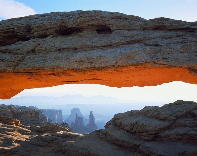
This is one of Canyonlands National Park’s most photographed locations. This favorite place for tripod-wielding photographers first thing in the morning is known for its unique sunrise lighting. This is, nevertheless, a busy location all day.
A parking lot is located directly on Grand View Point Road. It’s a 10-minute drive from the Visitor Center to get here (6 miles).
To get to the arch, this trip is only a short, simple stroll on a graded gravel and dirt trail. A visit here takes 30 minutes, although you can stay longer if you want to photograph the sunrise.
Grand Viewpoint
Grand View Point offers one of Canyonlands’ most stunning views and is also one of the park’s more accessible treks.
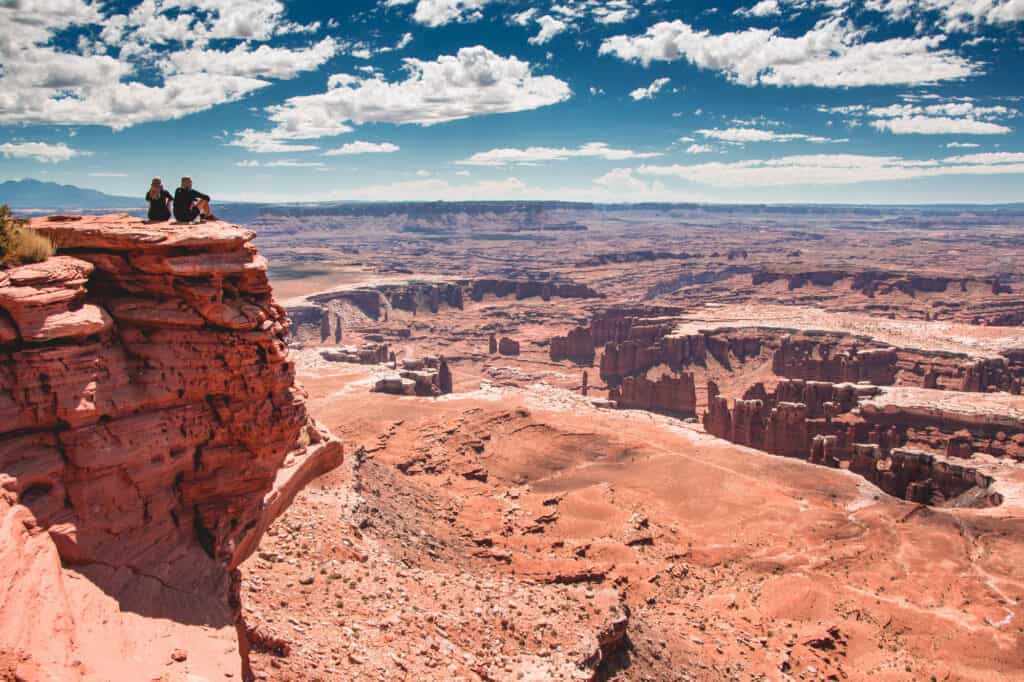
The majestic perspective of the park may be seen 15 minutes down the road from the Island in the Sky visitor center.
To get to the first viewpoint, take a 100-yard paved trail from the parking lot. This trail is accessible to wheelchair users. At the lookout, rangers frequently provide geology talks, and there are outdoor exhibits that describe the vista.
You can either relax and soak in the beauty or go for a hike on the Grand View Point Hike while you’re here. This hike is around 1.5 hours long and is 2 miles round trip.
If you just have a half-day in Canyonlands National Park, this is a must-see and one of the greatest places to start.
Buck Canyon Overlook
If you only have a limited amount of time, this is a beautiful viewpoint to visit. The views of the canyon are breathtaking, and it’s a tranquil portion of the park to just sit and take it all in.
The parking area, which is accessible through a paved walkway, is only a short distance from the viewpoint. There are some stunning views down into Buck Canyon. The Colorado River and the popular 4WD White Rim Road can be seen in the distance, as the La Sal Mountains emerge out of the red canyon rock.
This trail is so short that it can’t even be called a hike at only 0.1 miles, yet the breathtaking vistas make it worthy of a spot on this list. If you only have a limited amount of time, this is a wonderful viewpoint to visit. The views of the canyon are breathtaking, and it’s a peaceful area of the park to just sit and take it all in.
White Rim Overlook
This is a spectacular sky peninsula that is rather easy to reach. Around a mile from the end of Giants View Road is a picnic area; from here, stroll east before turning left at the junction. Then there’s a single track to the right that will take you to the White Rim Outlook.
This is a short 1.8-mile track that is ideal to do in the early evening, especially during the warmer months of the year. The elevated vantage point allows you a 300-degree vista of the canyon below.
Grand View Point and Buck Canyon Overlook vistas are combined into one jaw-dropping sight at White Rim Overlook. The top of the mesa provides panoramic views of Monument Basin and Buck Canyon, two of the Colorado River’s carved canyons.
There are a lot fewer people here than at Grand View Point and Buck Canyon Overlook since you have to hike to get here.
Upheaval Dome
There are a few theories about what caused the crater in the ground. It’s most likely a meteorite impact crater.
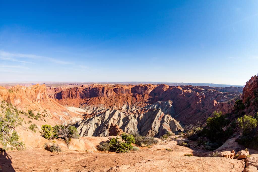
Some theories claim it was produced when a salty dome pushed its way up through the sandstone rock. In any case, this is a unique site to see in Canyonlands because it appears to be very different from the canyons visible from the overlooks.
The name Upheaval Dome comes from the fact that the rocks in the middle have been forced up into a circular structure known as a dome. It’s a fascinating spot in Canyonlands National Park since no one understands how it came to be, despite its beauty.
This is a hike with two different viewpoints. The first viewpoint is reached after a one-mile moderate hike. Upheaval Dome is visible from a short but steep walk that leads to a clear view. The trail will be a mile long if you continue to the second viewpoint. It’s 0.8 miles round way if you just hike to the first overlook.
You can take a detour to the top of a massive rock on your way to the second overlook. The views open out from here. You get panoramic views on this side of the park as well as a glimpse down into Upheaval Dome.
Whale Rock
Above Upheaval Dome, Whale Rock emerges. If you’ve always wanted to walk across a whale-shaped rock, now is your time.
Whale Rock is a lengthy sandstone formation that resembles a gigantic beached whale. The hike ascends 250 feet to the top of Whale Rock for a fun view of the Upheaval Dome and the surrounding canyons.
This short climb offers panoramic views as well as the opportunity to hike on bare Slickrock. The trek to the top of the rock is short but strenuous, but once there, you’ll be rewarded with spectacular views over the park.
Follow the sandy trail to the east side of the rock, where you’ll find the route upwards with handy handrails. It takes only a few minutes to climb and then you can easily walk along the whale rock.
Aztec Butte
This hike, like Whale Rock, has more Slickrock and panoramic views. Take the short spur trail to see historic granaries along the way.
This trail begins at the Aztec Butte Parking Area, which is located on Upheaval Dome Road. The track is well-marked and easy to follow from here. The hike ends at the summit, and you can return using the same route. The hike is short and great if you only want to do a little more exploring in Utah’s Canyonlands National Park.
The Anasazi granaries and built-in alcoves below the rim of a steep-sided mesa can be seen along this trail. This is a true historical trip that will allow you to witness structures that were left behind by the ancient Ancestral Puebloan people who lived here hundreds of years ago.
The final result of this short 2-mile round trip hike, in addition to the interesting rocks along the way, is wonderful vistas of the neighboring canyons.
Syncline Loop
The route’s steep switchbacks, boulder fields, and Slickrock require athleticism to navigate. The loop is only suitable for experienced hikers.
Expect longer travel times than the distance and change in elevation suggest. The pace will be hampered by uneven terrain and periodic loss of clarity. Carry plenty of water and go slowly so you don’t miss any cairns marking important landmarks.
On the Syncline Loop, visitors will be treated to breathtaking backcountry scenery, lush riparian corridors, and a variety of wildlife. Upheaval Canyon leads to Green River and the Upheaval Dome Crater.
This hike takes 6 to 8 hours according to the National Park Service, but it can be completed in much less time. The Syncline Loop is open year-round for hiking. When temperatures are mild, spring and fall are the best months to visit. Expect high temperatures in the middle of the day in the summer. The trail may be covered in snow or ice during the winter months due to the cold temperatures.
Gooseberry Hike
Canyonlands National Park has several hikes that provide panoramic views of the White Rim. This category includes both Grand View Point Trail and White Rim Overlook. The Gooseberry Trail, on the other hand, is an excellent hike to consider if you want to hike below the level of the mesa and onto the White Rim.
The Gooseberry Trail is known for being Canyonlands National Park’s steepest. The trail drops almost 1,000 feet in less than a mile. And, since everything must return to its original place, you’ll have to climb back up these crazy switchbacks at the end of the hike.
You are rewarded with amazing views across the White Rim while going down the first, steep part. Plus, climbing below the mesa’s level and walking on the White Rim has its own unique experience. Most visitors only get a glimpse of the Canyonlands from the mesa’s overlooks. This hike allows you to escape some of the crowds and add a bit more excitement to your Canyonlands visit.
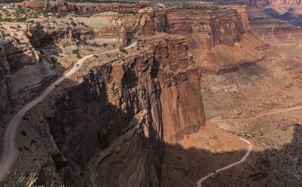
Shafer Canyon Road and Potash Road
This is a great one if you appreciate picturesque driving and white-knuckle highways. You’ll drive the iconic Shafer Canyon switchbacks, pass beneath Dead Horse Point, enjoy a close-up glimpse of the Colorado River, and witness Thelma and Louise Point, a famous movie filming location.
Two dirt roads connect Canyonlands National Park with Moab: Shafer Canyon Road and Potash Road. This driving does not require a permit… Only a high-clearance SUV and a strong sense of adventure are required.
Horseshoe Canyon
Canyonlands National Park’s Horseshoe Canyon is a distant extension. It houses some of North America’s most important rock art, including “The Great Gallery,” which features well-preserved, life-size humanoid figures with elaborate designs. Horseshoe Canyon is a great place to go hiking.
The Canyon and the remainder of Canyonlands National Park are not linked. It is about halfway between Green River and Hanksville. The majority of visitors arrive at Horseshoe from the Hanksville side, over a 30-mile graded dirt route from Utah Highway 24. The turnoff is marked. You can also take a 47-mile dirt road from Green River. From Moab, it takes around 2.5 hours and 1.5 hours to go to Green River. From the Hans Flat Ranger Station, a four-wheel-drive road runs to the east wall of Horseshoe Canyon.
Horseshoe Canyon does not allow camping. At the trailhead and on BLM property near the rim, camping is permitted. At the trailhead, there is a vault toilet. There are no other services available, and camping is free.
The canyon’s trail is well-marked with rock cairns. Simply walk up-canyon once you reach the bottom. About a third of a mile up the canyon, on your left, is the first rock art panel. It is visible from the route and has a sign indicating its location. Other panels will be on the right, and will be visible; some will not be signed.