15 Best Hikes in Zion National Park
Zion Hikes: Hiking in Zion National Park is one of the most rewarding experiences and best ways to see more of the park. Don’t worry, you do not need to do an all day hike in Zion to see some of the beautiful landscape. I have several easy hikes on the list and even some family friendly hikes in Zion too.
In this list of the Best Hikes in Zion National Park, I have included helpful information on how long the hike is and tips you need to complete the hike.
15 Incredible Hikes in Zion National Park – for all fitness levels!
Weeping Rock
This trail is the shortest in the park at half a mile round trip, however, it is unsuitable for wheelchairs and strollers due to broken pavement and a moderately steep slope. To begin, walk along a walkway that crosses drainage streamlined with cottonwood, ash, and maple trees.

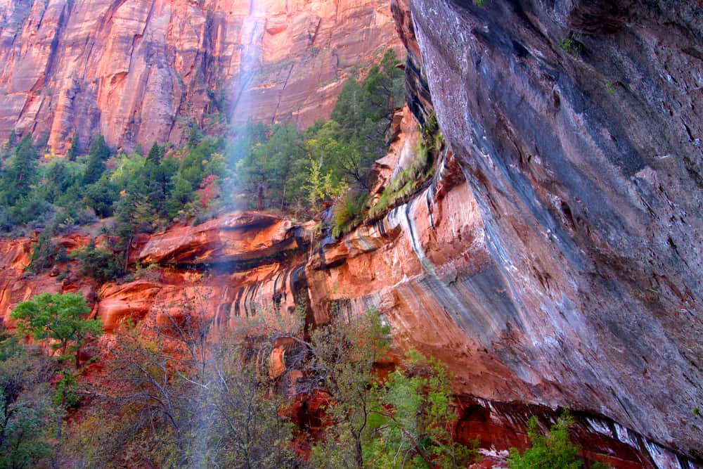
Weeping Rock is one of Zion Canyon’s most popular sites, and it can be reached through a quarter-mile paved trail. Water flows out of the confluence between two separate sandstone strata (the Navajo and Kayenta layers), generating a year-round spring that sustains hanging gardens of moss, ferns, grass, and wildflowers.
During the winter, the approach road (Zion Canyon scenic drive) is open to private vehicles, but between March and October, the only way to get to Weeping Rock is to walk or cycle the 4.5 miles from Canyon Junction, or to take the free park shuttle bus (stop number 6 if starting from the visitor center). The short trail crosses the stream on a footbridge then follows the creek uphill past bushes and cottonwood trees to the base of the rock, a cool, sheltered place kept permanently moist owing to the dripping waters from above.
Emerald Pool Trail
The Emerald Pools Trail is a Zion classic and one of the most family-friendly hikes in the park, with soaring walls, deep pools, waterfalls, and hanging gardens. Depending on how far you choose to travel, the Lower Upper and Middle Pools route vary in complexity from a simple walk to an easy hike.
The Emerald Pools Trail begins in Zion Canyon at the Zion Lodge shuttle stop. The only way to get to the trailhead, except for a few months in the winter, is to take the free Zion Shuttle. The shuttle operates from the Visitor Center to the Temple of Sinewava at the top of the Zion Canyon Scenic Drive.
Follow the pathway towards the Zion Lodge and across the main canyon road to the entrance of the Emerald Pools Trail at a footbridge across the Virgin River from the Zion Canyon shuttle stop.
The Lower Pool contains some beautiful waterfalls that cascade over the trail’s summit. Swimming is no longer permitted in the pools, but hikers can still cool themselves as the water flows down the trail below the falls. Throughout the year, the size of the falls varies. They are typically greater in the spring and after storms, but at other times, they may slow to a trickle.
For the Middle Pools, this just the streams feeding the waterfalls you passed under at the Lower Pool. There are chains and warning signs to keep hikers from getting too close, so use caution in this area. From the Middle Pool, the trail becomes more rugged and strenuous as it climbs the final half-mile and 200 feet of elevation to the Upper Pool.
Finally, The Upper Emerald Pool is also the conclusion of Heaps Canyon, an extremely technical canyoneering trek in Zion. Canyoneering is a demanding sport comparable to rock climbing in which expert teams use ropes and other technical equipment to descend slot canyons. If you’re lucky, you’ll get to see expert canyoneers down the final 300-foot free-hanging rappel.
Angel’s Landing
This hike begins in the Grotto and takes three to six hours to complete. The trail is available all year, but it can be quite hot and crowded in the summer, and entirely covered in snow in the winter.
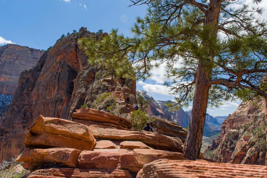
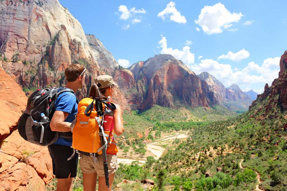
Angels Landing in Zion National Park is the most popular and well-known hike, leading to one of the park’s most iconic sights. This magnificent climb will take you to a breathtaking vantage point with a panoramic view of the canyon. This spectacular route begins with a series of switchbacks known as Walter’s Wiggles as it climbs the side of a mountain before traversing a narrow ridge to a 1,500-foot plunge and a glimpse of the valley.
The hike is not recommended for individuals who have a weak heart, fear of heights, and young children as one section of the trail involves holding onto a chain bolted onto a cliffside with sheer drop-offs.
Riverside Walk
This path, also known as the Gateway to the Narrows, is wide, paved, and as simple to maneuver as a local sidewalk. It begins at the Temple of Sinawava, near the end of Zion Canyon’s generally accessible section. During the day, cottonwood trees shade the bulk of the trail, providing a pleasant shade that is complemented by the cool waters of the North Fork of the Virgin River.
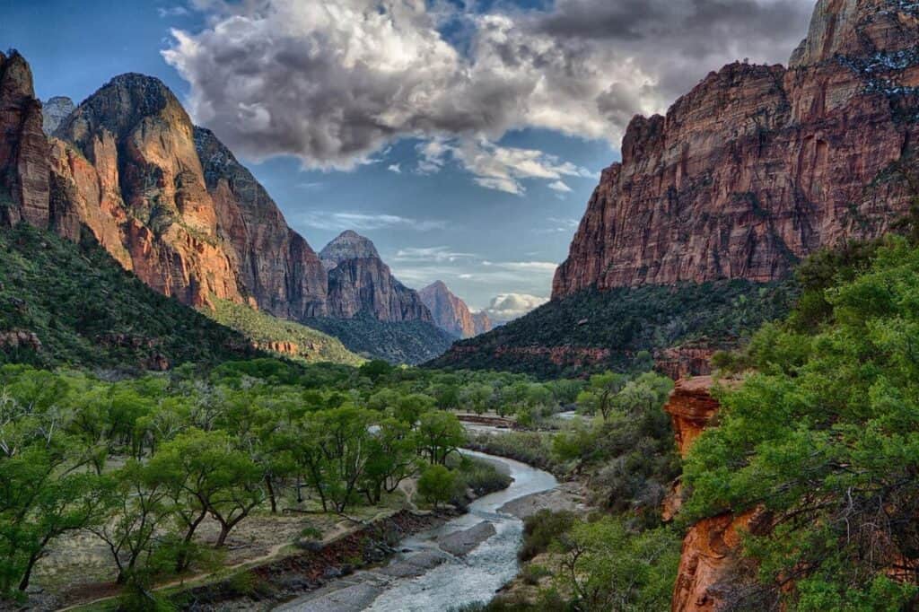
The Zion National Park’s Riverside Walk, also known as The Gateway to the Narrows, is arguably the best, most scenic wheelchair accessible, family-friendly hike in the world. (Some stretches may require help for wheelchairs.)
The Riverside Walk is a great place to catch a glimpse of the local Zion wildlife. Lizards, birds, and some unusually friendly squirrels are common along the trail. Mule deer sightings are also common, especially in the evening. Keep a safe distance from all wildlife and never feed them.
Hikers should be cautious because the trail follows the Virgin River’s carved channel, which has some modest drop-offs. In addition, access to this path may be restricted during high-water occurrences, flash floods, and impending storms. Otherwise, have fun strolling!
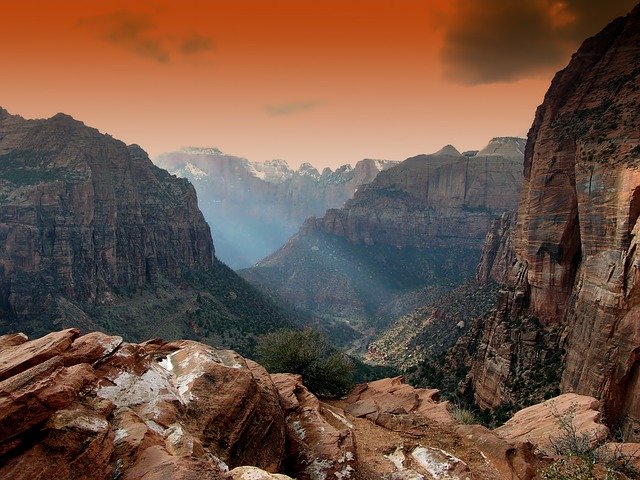
Observation Point
This popular trail leads from the bottom of Zion Canyon to the rimrock that climbs far above it in a long and steep ascent. There are spectacular vistas along the way, including the lower sections of Zion Canyon, a quick glimpse into Echo Canyon’s tiny slot, and views of the cliffs above high Echo Canyon during the final climb.
Observation Point itself is perched high above Zion Canyon and is the most accessible of the rimrock overlooks that line the canyon wall. The trail begins by zigzagging vigorously up an amphitheater carved out of the wall of Zion Canyon by the river. About two-thirds of the way up the grade, a spur trail climbs southward into the cleft of Hidden Canyon.
This eight-mile round-trip climb is one of the best for spectacular views and a unique perspective of Zion Canyon. This is a challenging climb up to and into Echo Canyon, passing by steep drop-offs and Zion’s stunning Navajo sandstone.
Canyon Overlook
This one-mile hike off the Zion-Mount Carmel Highway takes you to a high vantage point with magnificent valley views: Curving around the side of a mountain, hugging the cliff wall, swerving out onto a wooden footbridge stretched over a drop-off, and affords amazing vistas around every bend.
The trail begins with a collection of stone steps north of the road, across the street from the parking area on Highway 9 just east of the tunnel. You’ll get a spectacular view of the Pine Creek slot canyon on your way to the viewpoint. There’s also a nice shaded alcove with ferns growing out of the walls that offers a bit of a break from the otherwise exposed path.
However, this trail is not suitable for young children because it requires you to negotiate narrow cliffs with no obstacles at points. Although the trail is relatively flat and well-traveled, it contains switchbacks, steps, and Slickrock despite its short duration as the path also obtains the designation of moderate difficulty.
Canyon Overlook is located on the Zion of Mt. Carmel (East), side of the park. This trail is one of the most spectacular and relatively easy to access overlooks in all of Zion National Park.
Hidden Canyon
Hidden Canyon is a narrow and deep “hanging canyon” hidden above the main canyon east of the Great White Throne. The constructed trail rises the east side of the main canyon, traverses a few ravines, and finishes at the mouth of Hidden Canyon, allowing hikers to go as far as they can. This hike is fairly strenuous with an elevation gain of over 1000 feet, several exposed sections, and plenty of rock scrambling in Hidden Canyon. It may take anywhere between 3 to 6 hours depending on how much you explore.
The Weeping Rock Trailhead, which is also the 7th stop on the Zion Canyon Shuttle, is where the trek to Hidden Canyon begins. Begin your hike by walking up the paved trail that runs parallel to the main canyon on the east side. You will eventually reach the junction of the Hidden Canyon Trail. Follow the trail where you will hike up sandy switchbacks with excellent views.
Small sandstone caves and a 20-foot natural arch can be found along the trail. There is also some very steep thin tracked rock parts on the trail. Although there are chains to safeguard hikers in some areas, all hikers should exercise caution. Some sections of this may be tough for those who are afraid of heights.
The Narrows
Hiking the Narrows is an amazing experience due to its unique terrain and magnificence. For those who don’t want to miss out on this experience but have never done a trip like this before, hiking the Narrows with a guide is recommended.

The Narrows is one of the premier hikes in the park and on the Colorado Plateau. It is the narrowest section of Zion Canyon in Zion National Park, Utah, United States.
The Narrows, Zion’s most famous feature, is the slot canyon of all slot canyons, and hikers who don’t mind getting wet can follow the Virgin River down this stunning rock-cut. Hikers can walk, trek, and swim in a tight canyon encircled by massive red sandstone canyon walls, where the Virgin River has worked for millions of years.
There are at least 3 Ways to Hike the Narrows:
- Overnight Through-Hike from the Top
A fantastic one-night backpacking adventure of The Zion Narrows hike for experienced backpackers is worth it when completed in its entirety. You won’t even need a tent most times of the year!
In addition, the weather forecast must be clear and without the threat of storms or flooding because you’ll be spending the night in the canyon.
A more leisurely way to hike, enjoy, photograph, and explore. Depart from Chamberlain’s Ranch. Shuttle and permits are also required.
- One-Day Through-Hike from the Top
Hike the entirety of the canyon (16 miles) in one day from Chamberlain’s Ranch through a car, shuttle, and permit as these are required.
This is a reasonable option for the athletic, and it makes for a fantastic trip and introduction to Zion. Take another day, if possible, to enjoy this memorable trip, which will allow you to take photos, explore side-canyons, play in swimming holes, and relax in camp.
- Day Hike from the Bottom
Due to its ease as well as little physical commitment, this is the most popular option. You can hike in as far you would like and turn back at any time but Bottom-Up hikers are only permitted to hike as far north as Big Springs. Orderville Canyon is also worth a visit if you have extra time.
You can hike in and out from the Temple of Sinawava via the Riverside Walk to Wall Street and back. You’ll need to ride the shuttle into Zion Canyon, to Temple of Sinawava, and that takes about 45 minutes during the summer season.
It’s an excellent half-day or full-day trek with simple logistics. When a through-hike isn’t possible in the winter, this is a decent solution. A permit is not required for day hiking from the bottom.
The Narrows is located on the North Fork of the Virgin River and upstream of the main canyon.
The Subway
In Zion National Park, the Subway is a typical semi-technical slot canyon walk. You must wade, swim, scramble or climb down the Left Fork of North Creek to finish the hike. For the most part, the trail follows the creek. Some of the holes are deep enough that swimming is required, and the water is extremely cold.
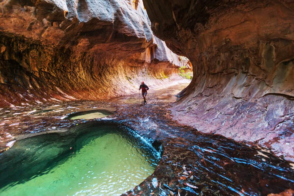
There are two options for traversing this difficult path. The first is a top-down approach, and the second is a bottom-up approach. Both are extremely challenging and physically demanding, but top-down is the easier of the two. As a result, most hikers prefer to hike the Subway from top to bottom. The hike can take anywhere from six to twelve hours, depending on the hiker’s experience and time spent sightseeing through the hike.
The Subway is open for hiking in all seasons, however, the ideal times to hike are in the fall and summer. Hiking this trail has advantages and disadvantages depending on the season. Hikers can choose the best time of year for their preferences by knowing what to expect at the Subway during each season.
Watchman Trail
The Watchman formation, which stands sentinel above the mouth of Zion Canyon, is both an identifiable landmark and the subject of considerable photographic scrutiny. The majority of visitors photograph and appreciate the Watchman from the Pa’rus Trail and the Canyon Junction Bridge, hoping to capture the iconic sunset view with the Virgin River in the foreground.
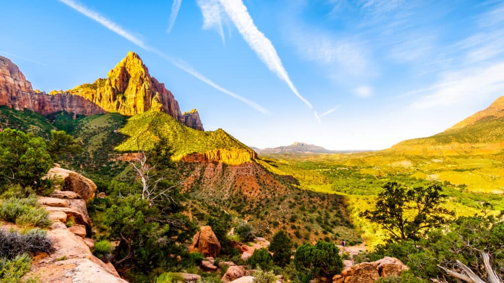
The trail begins at a trailhead on the Virgin River’s eastern bank, immediately across from the visitor center. The first half of the trail follows the river northward before turning east to cross an access road twice, at 0.25 and 0.4 miles. At 0.5 mile, the trail crosses dry streambed one last time before settling into an upward groove through a deep, amphitheater-like canyon.
This hike is best done in the late evening or at sunset. The canyon opens up to the southwest south of the Watchman, and the late evening light from the setting sun bathes the canyon’s eastern walls in golden light.
While the trail does not lead to the summit of Watchman Mountain, it does provide a good view of the famed and spectacular peak to the south, as well as a bird’s eye view of the entire Visitor Center complex below.
Kolob Arch
One of the world’s greatest freestanding arches is hidden deep into a side canyon feeding into La Verkin Creek Canyon. Kolob Arch spans 287 feet across open space above a densely forested grotto. This path through La Verkin Creek Canyon is ideal for a relaxing backpacking trip or a challenging day hike through the relatively calm boundaries of La Verkin Creek and Timber Creek Canyons.
In 2006, The Natural Arch and Bridge Society concluded that Kolob Arch is the second longest natural arch in the world measuring 287.4 feet.
The arch can be reached in one of two ways. Hikers can first descend from the Kolob Canyons Road parking lot at Lee Pass into the drainage that eventually becomes Timber Creek, which is the most popular option. Hikers then loop around Gregory Butte’s southwest offshoot and into the La Verkin Creek valley. Right before the trail turns onto the Hop Valley Trail, the Kolob Arch viewpoint is up the tiny canyon to the north of the La Verkin drainage.
Hikers can also begin their trip at the Hop Valley Trailhead, which is located near the intersection of Kolob Road. Although both routes are seven miles long, this one is more direct (one way). Turn west into the La Verkin drainage after seven miles on Hop Valley Trail, and Kolob Arch will be northward, up the first little canyon.
Furthermore, Hikers can descend Icebox Canyon, a tricky path involving five distinct rappels, to make this a circular trip—and a more adventurous route. The three-mile-long narrow canyon dips down into the shallow canyon where Kolob Arch stands.
Sand Bench Trail
Between the Court of the Patriarchs and Zion Lodge, the Sand Bench Trail is a loop hike that runs along the east and west banks of the Virgin River: a sandy side trail even extends to the Grotto. Some areas of the route are heavily utilized by the Zion Lodge trail horses and may have deep sand, while others are pleasant to stroll or run on.
As one reaches Zion Canyon, the vast earthen shelf off to the left of the Floor of the Canyon Road, below the colossal heights of the Sentinel, is known as the Sand Bench. The Sand Bench, which is made up of the ruins of an ancient massive landslide and several more recent, smaller landslides, is known as Zion’s horse trail.
The trail is incredibly sandy, making it a much more difficult hike than a horseback ride, but it is well worth the effort to enjoy the scenery along the way and the picnic area at the end.
You won’t get far from civilization because the route is usually always visible from the main canyon drive. However, whenever you stroll along the river in Zion, you increase your chances of seeing vegetation and fauna. A horse-free walk on the Sand Bench early or late in the day, or any time during the winter off-season, will provide you with unreversed delights.
Timber Creek Overlook Trail
The Timber Creek Overlook Trail is a short stroll that heads south from the main parking lot to offer more pleasant views from the top of the ridgeline.
The Timber Creek Overlook Trail leads to an outcrop with panoramic views of the Kolob Canyons, Pine Valley Mountain range, Timber Creek drainage, and Red Butte after a.6-mile hike. The trail heads south, climbing an exposed slope to a tiny mountain. Views extend from the Kaibab Plateau (south) to the Grand Canyon’s North Rim on clear days.
The greatest vistas, however, are to the east, in the Kolob Canyons area. Huge sandstone structures exist side by side, separated by broad-mouthed finger canyons, and provide a peek into how erosive forces created this terrain.
The Colorado Plateau, which has been steadily eroding for millions of years, includes all of these formations. On a macro scale, this vantage point atop the plateau provides a unique perspective.
An expedition to the Kolob Canyons part of Zion Canyon is a perfect way to get away from the heat and crowds of Zion Canyon.
East Rim Trail
Back before the 1980s, the name “East Rim Trail” used to refer to the trail that went all the way up to Observation Point. The trail through Echo Canyon was referred to as the “Echo Canyon Trail.”

At present, the term “East Rim Trail” refers to the full trail that runs from the East Entrance to Weeping Rock, going through Echo Canyon.
Between a trailhead at the park’s east entrance and the Weeping Rock Trailhead in the canyon, the 10.8-mile East Rim Trail follows the eastern rim of Zion Canyon. The first few miles at each end of the path are the best parts of the long hike. Instead of hiking the entire trail, which involves a car shuttle, most hikers tackle these parts as out-and-back trips.
Hiking the trail takes between six and eleven hours and includes a 1,000-foot elevation gain on the east end and a 2,400-foot fall into Zion Canyon on the west. It’s also a dry climb because the only source of water is the seasonal Stave Spring. Backpackers frequently combine this fantastic route with the West Rim Trail to form a 47-mile trans-Zion trek across the national park.
This trail is best in the late spring and fall. The trail typically has deep snow in the winter that can remain until late spring. During the summer months, the trail can get very dry and hot. This area has no established campsites but does require a permit for overnight trips.
Pa’rus Trail – family friendly
The Pa’rus Trail, named after the Paiute term for “bubbling water,” is one of Zion National Park’s newest and most accessible paths. It’s the only path in Zion that allows bikes and pets, and it’s one of the park’s few wheelchair-accessible trails, albeit a few rougher spots will require assistance to get around.

Starting at the South Campground just north of the Visitor Center, this wide, paved trail skirts the Virgin River in the flat and open lower section of Zion Canyon and ends at the Canyon Junction. The scenery is extremely pleasant throughout the trip, with multiple bridges crossing the river, various wildflowers, and mule deer frequently spotted.
This popular bike trail is also a great place to walk if you want to enjoy a semi-long stroll through the sunny Zion scenery. It connects the ranger station, park offices, campgrounds, the museum, and other locations, and is broad enough to enable bicycle, wheelchair, and stroller traffic at the same time. You can walk the path for an entire afternoon or for a shorter period of time.
Many people use the instead of relying on park shuttle buses. This provides visitors with a one-of-a-kind experience, increasing opportunities for physical exertion and activity while also relieving them of the crowds that normally fill up the shuttle system.