15 Fun Things to do in Bryce Canyon National Park, Utah
Bryce Canyon Attractions: Bryce Canyon has a ton of things to do. It is full of hoodoos and breathtaking lookouts. If you are short on time you can visit Bryce Canyon in one day and still hit all the major spots. Bryce Canyon National Park is one of the Mighty Five National Parks in Utah and offers some of the best activities.
The scenic drive around Bryce Canyon is 38 miles long and takes you to all of the views. We arrived at the Visitors Center at 9 a.m., and it was already pretty crowded.
Because of the large number of people already in the park, we decided to drive to the far end and then make all of our stops on the way out. Another feature of Bryce Canyon National Park is that all of the overlooks are on the left on the way out to the end and on the right on the way back to the visitors center.
Thank you for supporting this website written by an American. This post may contain affiliate links. This means I earn a small commission on these links at no extra cost to you.
National Park Entrance Fees
To enter the National Parks, you’ll need to pay an entrance fee or have a National Parks Pass also known as American the Beautiful Pass.
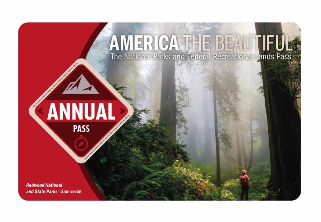
It costs $80 for a yearly America the Beautiful Pass. This gives you access to all national parks and federal areas that charge fees. The America the Beautiful Pass is well worth it!
I purchased my first one in 2016 and it’s such a money-saver! Plus 10% of sale proceeds go to the National Park Foundation.
Tips for Visiting Grand Teton National Park
Grand Canyon National Park is perfect for outdoor enthusiasts. There is something for everyone on this list and for different fitness levels. Also, note that it is dry and hot (in the summer), and make sure you know what you are getting into before you start. Here are a few tips for visiting the Grand Canyon:
- Bring a reusable water bottle and lots of water! Remember you are in the sun and you will need to drink lots of water. I love my LifeStraw Filtered Water Bottle. I can refill this bottle anywhere and it comes with a carabiner to connect it to my daypack.
- Check the Weather – days over 100 degrees are very common. Make sure to check.
- Hiking boots or sandals that will protect your feet! I love good shoes. I need all the support and help I can get. I actually love these sandals for hiking and also love these hiking boots.
- Bring hiking poles for balance and to protect your knees. I know many experienced hikers (and even amateur ones) think that hiking poles are for old people who lose their balance. Actually, hiking poles can help when going down steep inclines or when scrambling over rocks. They are great to hike with even for the most experienced hiker.
- Wear a sunhat. I feel like this whole post is about how high you are in the mountains and how much closer you are to the sun but it is so true. At elevation, you are closer to the sun and more likely to burn. Wear sun protection such as a sun hat and sunscreen.
- Be aware of the wildlife. This is the Southwest and you will need to watch out for snakes and other wildlife such as moose or a bear. Please stay away from wildlife and do not feed them. I recommend carrying bear spray as well.
- Start Early – If you want to avoid the traffic and the heat you will need to start your hike early. That way it will be nice and cool and the smog will not affect you either.
- Leave no trace. If you are new to the concept of Leave No Trace it is all about preserving the environment to ensure it is in the same or better condition when you leave it. This means that you should stick to the trails and carry out everything that you carried in. This is a great explanation of the Leave No Trace principles!
- Water shoes are great for water hikes– If you don’t have a pair, I highly suggest it as they are affordable. I have an article on the pros and cons of several pairs of water shoes.
- Bring Bug Spray and a snack: Be sure to bring everything you need including a snack like a protein bar plus BUG SPRAY.
Where to stay near Grand Canyon National Park
The Grand Canyon makes for a great weekend escape. Fresh air, beautiful scenery and being in nature does a world of good for the soul. I recommend staying as close to the park as possible and even treating yourself with a cabin with a spa pool to relax at night.
- There are lots of fantastic Airbnbs near the Grand Canyon. I have made a list of the best airbnbs around the park wherever you decide to stay. You can also check out my post on Where to Stay near the Grand Canyon to find the perfect hotel for any budget.
If you are taking a road trip remember to reserve a car in advance using Discover Cars .
National Park Entrance Fees
To enter the National Parks, you’ll need to pay an entrance fee or have a National Parks Pass also known as American the Beautiful Pass.
It costs $80 for a yearly America the Beautiful Pass. This gives you access to all national parks and federal areas that charge fees. The America the Beautiful Pass is well worth it!
I purchased my first one in 2016 and it’s such a money-saver! Plus 10% of sale proceeds go to the National Park Foundation.
Tips for Visiting Grand Teton National Park
Grand Canyon National Park is perfect for outdoor enthusiasts. There is something for everyone on this list and for different fitness levels. Also, note that it is dry and hot (in the summer), and make sure you know what you are getting into before you start. Here are a few tips for visiting the Grand Canyon:
- Bring a reusable water bottle and lots of water! Remember you are in the sun and you will need to drink lots of water. I love my LifeStraw Filtered Water Bottle. I can refill this bottle anywhere and it comes with a carabiner to connect it to my daypack.
- Check the Weather – days over 100 degrees are very common. Make sure to check.
- Hiking boots or sandals that will protect your feet! I love good shoes. I need all the support and help I can get. I actually love these sandals for hiking and also love these hiking boots.
- Bring hiking poles for balance and to protect your knees. I know many experienced hikers (and even amateur ones) think that hiking poles are for old people who lose their balance. Actually, hiking poles can help when going down steep inclines or when scrambling over rocks. They are great to hike with even for the most experienced hiker.
- Wear a sunhat. I feel like this whole post is about how high you are in the mountains and how much closer you are to the sun but it is so true. At elevation, you are closer to the sun and more likely to burn. Wear sun protection such as a sun hat and sunscreen.
- Be aware of the wildlife. This is the Southwest and you will need to watch out for snakes and other wildlife such as moose or a bear. Please stay away from wildlife and do not feed them. I recommend carrying bear spray as well.
- Start Early – If you want to avoid the traffic and the heat you will need to start your hike early. That way it will be nice and cool and the smog will not affect you either.
- Leave no trace. If you are new to the concept of Leave No Trace it is all about preserving the environment to ensure it is in the same or better condition when you leave it. This means that you should stick to the trails and carry out everything that you carried in. This is a great explanation of the Leave No Trace principles!
- Water shoes are great for water hikes– If you don’t have a pair, I highly suggest it as they are affordable. I have an article on the pros and cons of several pairs of water shoes.
- Bring Bug Spray and a snack: Be sure to bring everything you need including a snack like a protein bar plus BUG SPRAY.
Where to stay near Grand Canyon National Park
The Grand Canyon makes for a great weekend escape. Fresh air, beautiful scenery and being in nature does a world of good for the soul. I recommend staying as close to the park as possible and even treating yourself with a cabin with a spa pool to relax at night.
- There are lots of fantastic Airbnbs near the Grand Canyon. I have made a list of the best airbnbs around the park wherever you decide to stay. You can also check out my post on Where to Stay near the Grand Canyon to find the perfect hotel for any budget.
If you are taking a road trip remember to reserve a car in advance using Discover Cars .
Tips for Visiting in Zion National Park
Zion is perfect for outdoor enthusiasts. There is something for everyone on this list and for different fitness levels. Also, note that it is dry and hot (in the summer), and make sure you know what you are getting into before you start. Here are a few tips for visiting Zion:
- Bring a reusable water bottle and lots of water! Remember you are in the sun and you will need to drink lots of water. I love my LifeStraw Filtered Water Bottle. I can refill this bottle anywhere and it comes with a carabiner to connect it to my daypack.
- Check the Weather – days over 100 degrees are very common. Make sure to check.
- Hiking boots or sandals that will protect your feet! I love good shoes. I need all the support and help I can get. I actually love these sandals for hiking and also love these hiking boots.
- Bring hiking poles for balance and to protect your knees. I know many experienced hikers (and even amateur ones) think that hiking poles are for old people who lose their balance. Actually, hiking poles can help when going down steep inclines or when scrambling over rocks. They are great to hike with even for the most experienced hiker.
- Wear a sunhat. I feel like this whole post is about how high you are in the mountains and how much closer you are to the sun but it is so true. At elevation, you are closer to the sun and more likely to burn. Wear sun protection such as a sun hat and sunscreen.
- Be aware of the wildlife. This is the Southwest and you will need to watch out for snakes and other wildlife such as moose or a bear. Please stay away from wildlife and do not feed them. I recommend carrying bear spray as well.
- Start Early – If you want to avoid the traffic and the heat you will need to start your hike early. That way it will be nice and cool and the smog will not affect you either.
- Leave no trace. If you are new to the concept of Leave No Trace it is all about preserving the environment to ensure it is in the same or better condition when you leave it. This means that you should stick to the trails and carry out everything that you carried in. This is a great explanation of the Leave No Trace principles!
- Water shoes are great for water hikes– If you don’t have a pair, I highly suggest it as they are affordable. I have an article on the pros and cons of several pairs of water shoes.
- Bring Bug Spray and a snack: Be sure to bring everything you need including a snack like a protein bar plus BUG SPRAY.
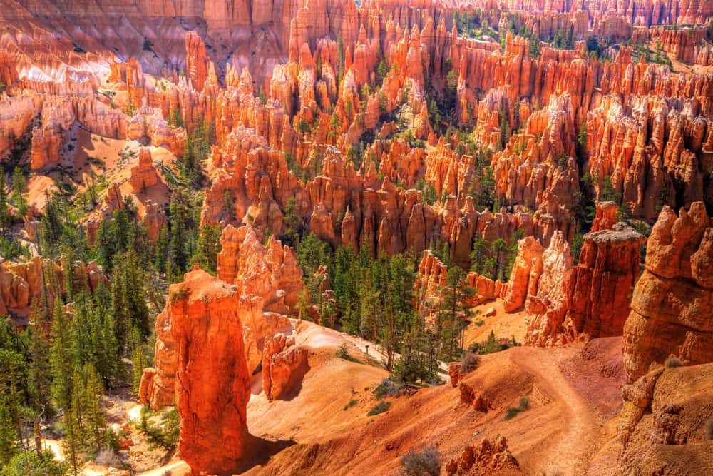
15 Fun Things to do in Bryce Canyon National Park
Visitor Center
One of your first visits for information about Bryce Canyon National Park should be the visitor center. The history museum and the 20-minute film “Shadows of Time” are both worth seeing.
It’s a must to begin your Bryce Canyon adventure at the visitor center. A ranger help desk, exhibitions on the area, interactive consoles, and a prairie dog maze can all be found here. Award-winning videos, as well as books, maps, and mementos, are shown every 30 minutes. Check the ranger program board for the most up-to-date information about hikes and tours, which range from geology presentations to full moonwalks.
Recent visitors praised the center’s enormous maps, which made it easier to organize their hikes, in addition to the pleasant employees. There is also a large parking lot and bathrooms here.
The visitor center is 1 mile inside the park, and it’s the first stop on the free shuttle route within the park. The visitor center is open to the public at no cost.
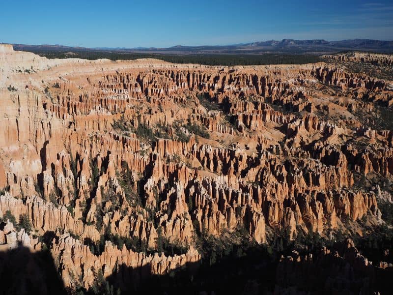
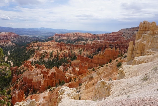
Inspiration Point
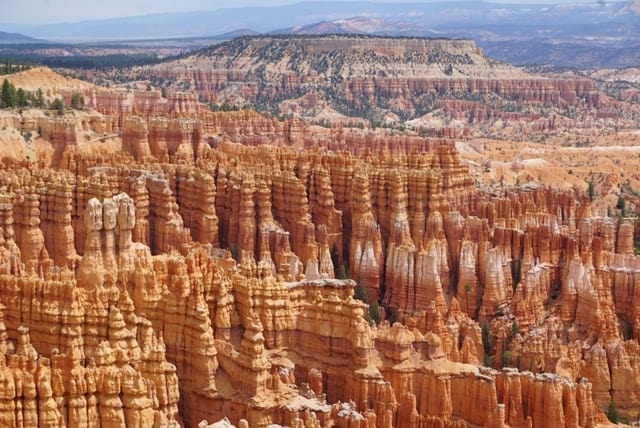
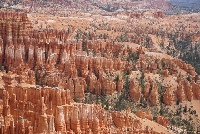
Inspiration Point, which has three levels of viewing, offers a variety of views of the main amphitheater. Visitors can see Silent City which is near Sunset Point with its endless rows of incomprehensible hoodoos. The view has been described as spectacular by visitors, who also observed that because there is a ramp available, it is a perfect opportunity for persons with mobility challenges to experience the incredible vista.
The park reports that the cliffs of Inspiration Point are highly perilous, with crumbly rocks, drop-offs, and steep slopes, and that no trails extend into the canyon. At all times, visitors should remain behind the railing. You can, however, walk to Sunset Point from here on a short, flat path that runs for less than a mile. The park’s free shuttle stops at Inspiration Point.
The 5.5-mile Rim Trail begins at Bryce Point in the south. Bryce Point is 1.5 miles from Inspiration Point. This part is closed throughout the winter. The viewpoint consists of three levels, each of which offers amazing views in all directions. The Claron Formation is made up of two members: the lower Pink Member, which is a “dirty” limestone with sand, silt, and iron that gives the rock its reddish hue, and the top White Member, which is a clean freshwater limestone. Although few hoodoos occur in this softer rock, the upper White Member of the Claron Formation is evident below Inspiration Point.
Except in extreme weather, the path is wheelchair accessible. Pets are allowed on this portion of the Rim Trail, but they must be on a leash and their owners must clean up after them. Fairyland Point is 3.8 miles away. Hikers can use this station, as well as stops at Bryce, Sunset, and Sunrise, to complete one-way walks during shuttle season. There is no shuttle service available at Fairyland Point.
Sunrise Point
The 1.8-mile Queens Garden Trail begins at Sunrise Point and descends into an area of hoodoos naturally dominated by the Queen Victoria hoodoo. Sunrise also marks the finish of a popular hike known as the Navajo Loop and Queen Victoria Combination. This is a fantastic overlook with stunning sunrises. However, if you can’t make it for sunrise, the beauty and colors are breathtaking at any time of day.
This picturesque site not only provides breathtaking vistas but also some of the park’s more imaginatively named formations. The Boat Mesa and the Sinking Ship, which are placed against the Pink Cliffs of the Aquarius Plateau, are visible to visitors. Boat Mesa rises to 8,073 feet above the hoodoos of Fairyland Canyon and is topped by the refractory granite known as “The Conglomerate at Boat Mesa.”
Sunrise Point is included in the park entrance fee. The free park shuttle stops at Sunrise Point, which is the 13th stop. The Bryce Canyon General Store, which contains a snack bar, restrooms, drinking water, and showers, is open from March to early January.
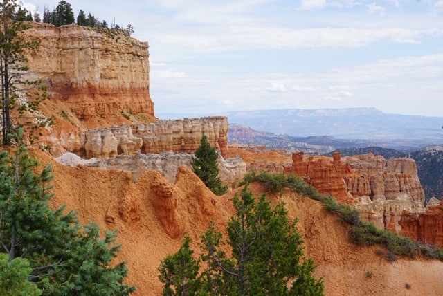
Sunset Point
On the aptly called Sunset Point Trail, where there are 360 views of the spectacular rock formations, get the greatest sunset seat in Capitol Reef NP. Sunset Point Trail is a short, easy 0.4-mile hike near the park’s entrance that offers stunning views of the Capitol Reef cliff from the other side of the park. As night falls, the setting sun reveals the red rim rock formations, providing the ideal photographic opportunities!
If you’re looking for a hike, the 1.3-mile Navajo Loop Trail is one of the most popular in the park, leading down into Wall Street, a slot canyon filled with 500- to 700-year-old Douglas firs. The Queens Garden Trail, which runs through the Queen’s Garden and terminates at Sunrise Point on the rim, is frequently paired with this trail.
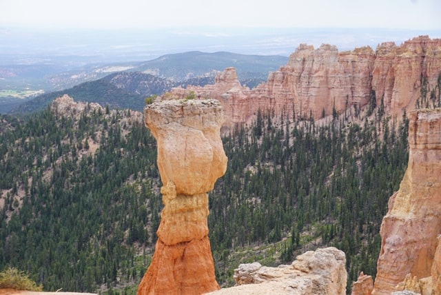
The Silent City, a maze of hoodoos and fins concentrated in a tight configuration, and Thor’s Hammer, located just below the viewpoint on the northern border, are two of Bryce Canyon’s most famous hoodoos. It’s easy to detect Thor’s Hammer because it stands alone. Sunset Point’s rock hues are vibrant, due to iron oxide minerals that bring out the rich reds, oranges, and yellows.
Attend a geology talk presented by a ranger. These 20-minute talks take place every day of the year at Sunset Point.
Further, an amazing rock formation with nature-made koozies awaits you at the end of the climb, great for helping you enjoy the sunset with some adult beverages!
Rim Trail
Hit the Rim Trail if all you want from your Bryce Canyon adventure is sweeping vistas of the hoodoos. The path weaves its way up the top of the amphitheater, providing spectacular views from every direction. The 5.5-mile one-way path passes by popular destinations such as Inspiration, Sunrise, and Sunset points, as well as Fairyland and Bryce Points.
From Fairyland Point to Bryce Point, the Rim Trail takes you through many height variations. Sunrise Point or Bryce Point are excellent places to watch the sunrise in spectacular color, while Inspiration Point and Sunset Point are best observed later in the day. Sunset Point also offers a glimpse of the legendary Thor’s Hammer.
The Rim Trail has been regarded as a pretty simple walk by previous visitors, who praised the paved part between Sunset and Sunrise points. They also appreciated the abundant and irresistible surroundings. You can also walk as much or as little as you wish on this trail.
The Rim Trail is accessible as part of the park’s admission fee. Although it is a short trail, you should wear strong hiking shoes and bring lots of water. Depending on where you want to trek, several shuttle stops allow access to the Rim Trail. These viewpoints can be reached by walking the Rim Trail, driving, or taking a shuttle, depending on your preference.
Queens Garden
Hikers can see remarkable rock structures such as Gulliver’s Castle, the Queen’s Castle, and Queen Victoria on a short trail that goes below the canyon rim.
The Queen’s Garden Trail is a 0.9-mile trail that descends 320 feet below the canyon rim. Hikers can loop back up to the rim by combining a connecting path with either branch of the Navajo Loop, even though the trail is not a loop. Gulliver’s Castle, the Queen’s Castle, and Queen Elizabeth herself, an amazing rock structure that rises 50 feet west of the trail’s finish intersection, are all notable rock formations along this famous path.
Because of the hoodoos that resemble a likeness of Queen Elizabeth, the area is known as Queen’s Garden. The first part of the hike, which is primarily gravel and downhill, may be difficult for young walkers. It may be slippery for little children and there is a high drop-off, thus, handholding is advised. Trekking poles are really useful for those who are a little unsteady. There are panoramic vistas of Bryce Canyon and a handful of excellent tunnels to explore. The trail comes to an end at the valley floor, where you can take a break and enjoy some shade.
You can either return the way you came or continue to the Navajo Loop trail, which will take you back up to Sunset Point, where you will find a short walk down to the Sunrise Point parking lot. The temperature in the summer can easily reach 100°F, so if you can, avoid hiking this trail in the afternoon. Instead, go early in the morning or late in the evening. Also, keep in mind that the park is located at an elevation of over 8000 feet above sea level.
Scenic Drive
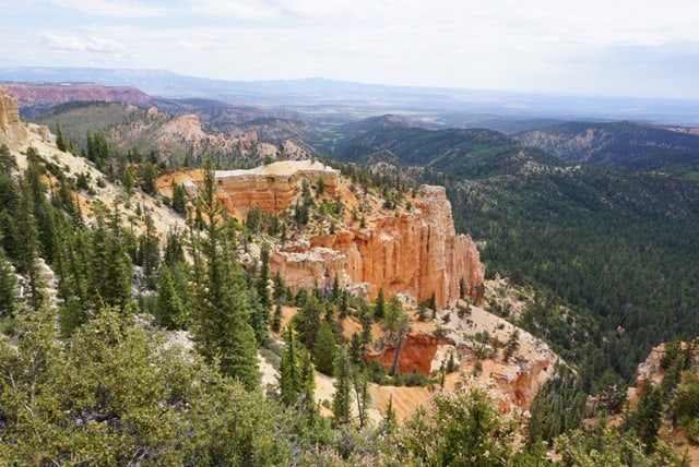
The park’s scenic road is 38 miles long (round trip) and includes 13 viewpoints. Although the northern overlooks have the most hoodoos, the southern overlooks have the best vistas. If you have the time, there are numerous hiking paths, ranger programs, and picnic spots to enjoy along the way.
Visitors are encouraged to begin their driving tour of Bryce Canyon National Park by driving directly to Rainbow Point, which is located at the park’s very southern extremity. As you continue north from there, the entire park opens up in front of you. Admission to the park includes access to the drive.
Byway 12, often known as Utah’s All-American Road, runs across the park’s northern section, connecting it to the Bryce Canyon area. Highway 63 travels south of Byway 12 through the park’s central section, through the visitor center, campgrounds, and all scenic views.
Allow for multiple hours of driving time to allow for frequent stops. Keep in mind that park rangers estimate the drive will take at least three hours.
Peek-A-Boo Loop Trail
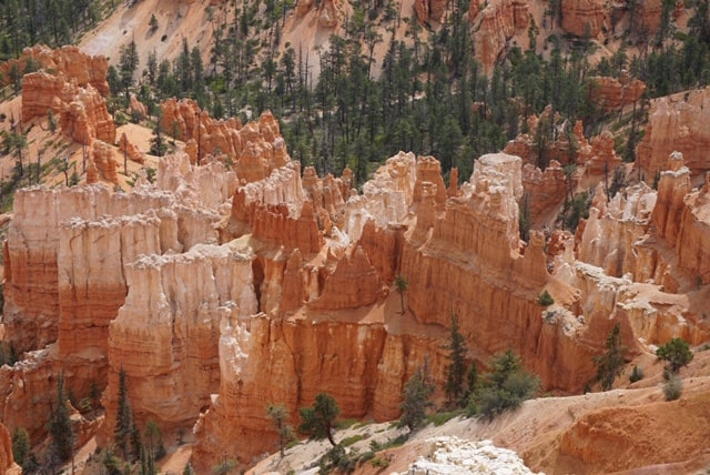
The 5.5-mile Peek-A-Boo Loop Trail, one of the park’s more difficult climbs, is a favorite among prior visitors for its spectacular views and rugged terrain. The Wall of Windows, a sandstone creation with hoodoos and arches, is the most famous site along this trip. You’ll walk amid the hoodoos as you explore the trail, getting a close look at the distinctive creation.
The trail begins with a dramatic drop into the canyon of 1,555 feet. Many sections of the trail are steep and in direct sunshine, according to hikers. Be sure to bring lots of water and snacks, as well as sunscreen and sturdy hiking shoes. You should be aware that you’ll be sharing the route with equestrian riders, and the park recommends that you give them the right-of-way. Additionally, this trail can only be hiked in the clockwise direction.
The trailhead for the Peek-A-Boo Loop is at Bryce Point, which has its own shuttle stop (No. 8). If you want to switch up your hike, you can join the Navajo Loop trail, which brings the overall distance down to roughly 5 miles.
Because of the sudden elevation change, and especially the climb back up, this hike is rated difficult.
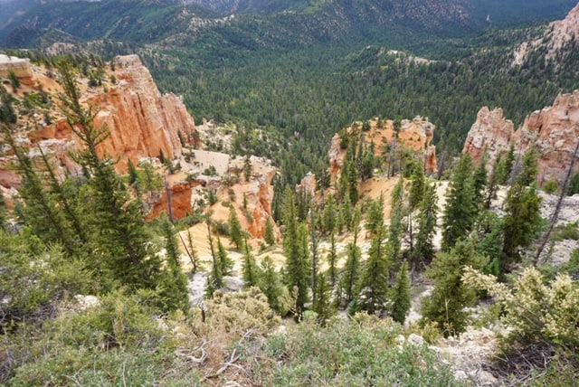
Mossy Cave Trail
The Mossy Cave trail is one of the park’s lowest elevation hikes, as well as one of the few that starts with a climb and concludes with a descent as most day hikes in the park begin with descent and end with a climb. It’s also the park’s northernmost trek, lying just off of SR 12 as it winds along the park’s perimeter. The trail is one-way for 0.4 miles and forks to allow access to Water Canyon in one direction and a protected overhang.
At first, this canyon known as Water Canyon, might look like any ordinary Bryce Canyon kind of canyon. That’s not the case. From 1890 to 1892, Mormon pioneers carved an irrigation ditch from the East Fork of the Sevier River over the Paunsaugunt Plateau and into this canyon with picks and shovels.
Water Canyon is distinguished by the presence of water alone. A broad variety of animals come here to quench their thirst on a regular basis, even if you don’t see them (animals tend to avoid crowded pathways – especially during daylight hours). The water supply is still new enough that nature hasn’t caught up yet. More riparian trees, such as willows and cottonwoods, are likely to sprout here in the future. Meanwhile, you’ll be astonished to encounter plants like Mountain Death Camas and Watson Bog Orchid, which you might expect to find by a brook in a mountain meadow.
In the summer, this area is covered in mosses, and in the winter, it is covered in icicles. Water flows periodically through Water Canyon on its way from the Tropic Reservoir east of the park to towns in the Paria Valley, thanks to the presence of an irrigation channel created by local pioneers in the early 1890s.
To go to Mossy Cave Trail, leave the national park and return to Highway 12, where you’ll turn right. At the trailhead, there is limited parking and a vault toilet. Since it is outside of the park and a little difficult to discover, this area of Bryce is also less crowded.
Rainbow Point
Rainbow Point is one of Bryce Canyon National Park’s southernmost overlooks. It provides a fantastic perspective of the park, especially the famous Amphitheatre. Rainbow Point is mostly paved and is only a short distance from the area’s parking lot. It’s also one of the park’s highest elevation sections.

This is located at the park’s southern extremity. It provides panoramic views of the entire park to the north. The Grand Staircase, a stratified rock feature, may be seen from Yovimpa Point, which is also located here. Each layer has a different hue and is labeled accordingly. The Pink Cliffs are the highest point on the cliffs. The Grey Cliffs are directly below, followed by the White Cliffs, the Vermilion Cliffs, and the Chocolate Cliffs, which are obscured from view. The views are amazing, and well worth the drive to this portion of the park.
If you’re planning on taking the Scenic Drive, the park recommends driving all the way to Rainbow Point, which is less than 20 miles south of the visitor center. You’ll find facilities and many trails near Rainbow Point, including the mile-long Bristlecone Loop route, which winds through a grove of up to 1,800-year-old bristlecone pines.
Keep in mind that as this is the park’s highest part, heights can reach more than 9,100 feet, so bring layers to deal with the weather variations.
Navajo Loop Trail
The Navajo Loop Trail, the most popular trail in Bryce Canyon National Park, takes visitors down the rim from Sunset Point, through the narrow corridors of Wall Street, past the Silent City, an intersection with Queens Garden Loop Trail, and to the top of Peekaboo Loop Trail, before ascending the amphitheater rim again at Sunset Point. Hikers must drop 800 feet down the edge of the Bryce rim, then ascend 800 feet back up that slope at the completion of the trip.
This is a popular trail that runs from Sunset Point on the rim of Bryce Canyon to the canyon’s floor in a 1- to 2-hour loop. Wall Street, Twin Bridges, and Thor’s Hammer are among the hoodoo formations visited on the trail.
The Two Bridges side and the Wall Street side make up the loop. It is open all year, however the Wall Street side is closed during the months when precipitation and freezing overnight temperatures are expected. The Two Bridges side can be hiked as an out-and-back or linked with other routes while Wall Street is closed.
Hikers will eventually be rewarded with views of enormous hoodoo formations on both sides of the path. Twin Bridges, one of these formations, is about a mile into the hike on the right side of the trail. To return to the rim, the trail ascends a series of switchbacks beyond Twin Bridges. Along this final stretch of trail, look for Thor’s Hammer to the north.
The Navajo Loop is sometimes coupled with Queens Garden to create one of the top three-mile hikes in the world.
Fairyland Canyon
This picturesque viewpoint, located 1 mile north of the park entrance station, is an excellent place to get up close with hoodoos. This viewpoint serves as the trailhead for the challenging 8-mile Fairyland Loop, which descends into the Fairyland, round Boat Mesa, and then ascends to meet the Rim Trail at Sunrise Point. Continue north on the Rim Trail to the Fairyland Canyon overlook.
Your park admission includes access to Fairyland Canyon. A small parking lot is accessible, but no further services are offered. The visitor center, about 2 miles southwest of the viewpoint, is the closest shuttle stop; from here, you can hike the Rim Trail to Fairyland Canyon.
Because of its length and meandering pathways with frequent elevation changes, this climb is considered strenuous. Since this hike normally takes 4-5 hours round trip over the 8 mile (12.9 km) length, bring plenty of water, 1 quart (liter) for every 2-3 hours of hiking per person. Sunscreen or wide-brimmed hats are suggested to avoid sunburn in the summer.
Visitors who completed the hike described it as absolutely stunning and a fantastic option for a day hike in the park. You’ll want to set up many hours to complete the walk because you’ll likely stop frequently for photo opportunities.
Natural Bridge
Natural Bridge is one of Bryce Canyon’s many natural arches, and it creates a stunning vista from this vantage point. The dark green of the Ponderosa forest that peeks through the arch from the canyon below contrasts sharply with the reddest granite of the Claron Formation molded into the arch.
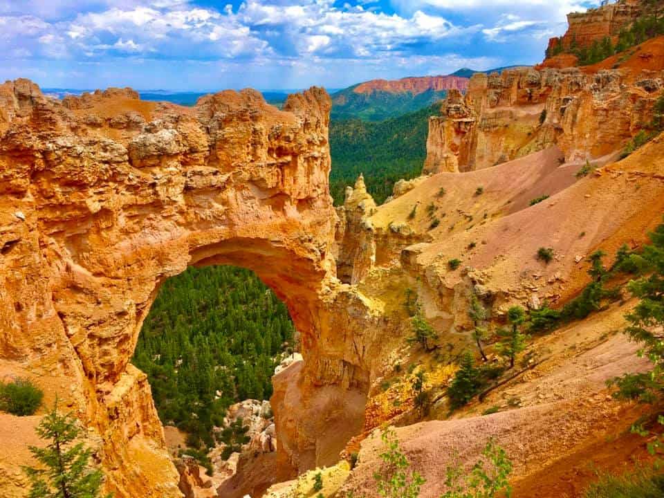
Natural Bridge is a witness to how even the most colossal rock formations may be vulnerable to a mix of natural forces—frost wedging, chemical weathering, and gravity. The arch can be seen from the Natural Bridge viewpoint, which is roughly three-quarters of the way along the scenic road through the park.
A small stand of Quaking Aspen can be found in the parking lot’s southern corner. Prior to the park’s strong fire suppression efforts of the last 75 years, historic images reveal that aspen were far more common throughout the southern half of the park. Spruce and Douglas Fir easily shadow out aspen. As you travel through the park, you’ll notice various locations where trees have been burned. Markagunt Penstemon can also be found near the parking lot.
Agua Canyon
The best view of Agua Canyon is from the lookout near mile 13.5 of the park road in Bryce Canyon National Park. Although there are no paths leading down to the canyon from here, the breathtaking view from above is well worth the stop. If you visit in the winter, please remember that this stretch of road is often closed due to snowstorms.
From the Agua Canyon Viewpoint, you can see two notable hoodoos. The hoodoo known as the “Rabbit” or “Backpacker” is located to the right. This one features a larger top and a narrower waist. The shape of this one is more like a wide tower. Many hoodoos have fallen or partially collapsed, according to the park, and no longer resemble the objects for which they were named.
In addition to the canyon views and hoodoos, Navajo Mountain, at 10,387 feet, may be seen on the horizon.
ATV Tours
Make your stay in the Bryce Canyon area an adventure you won’t soon forget. ATV ride with a guide is a fun and exciting way to see the region’s lesser-known locations. The ATV rides wind through ponderosa pine forests to the rim of Bryce Canyon National Park, providing a brief yet spectacular experience.

If you brought a 4X4 to the Bryce area or are looking for one to rent or even a tour, this tour is worth it. There is something for everyone on the Paunsuagunt Plateau, with its unending network of roads and trails. There are numerous overlooks that can only be reached with a four-wheel drive vehicle.
If you’re searching for a fun afternoon drive, Daves Hollow, located behind Bryce, is a fantastic choice. If you’re searching for a fun day trip or a beautiful spot to have a picnic, the trail system west of Tropic Reservoir is a great option. Please contact any of the local guides and tour companies if you think a guided tour is the best option for you and your group!
These guided tours will not only get your heart racing, but they will also present you with breathtaking views of a pristine alpine terrain, the Bryce Canyon Rim, and pure, fresh air. View some of the most breathtaking views that only a few people get to experience.