15 Best Things to do in Canyonlands National Park for First Timers
Planning a trip to Canyonlands and wondering what are the best things to do in Canyonlands National Park? I’ve highlighted some epic Canyonlands attractions you won’t want to miss!

Canyonlands is located about half an hour outside of Moab, Utah. Most people visit both Canyonlands and Arches National Park in one day but there is plenty to do in Canyonlands.
Canyonlands has 527 square miles of infinite deep canyons, towering mesas, pinnacles, cliffs, and spires. Canyonlands National Park was created by the Green and Colorado rivers’ currents and tributaries. It offers a diverse range of travel opportunities, from breathtaking isolation in the park’s more isolated areas to moderate walks through the Needles sector and the chance to create your own version of Mesa Arch, one of the West’s most photographed features.
Do yourself a favor and take your time when walking through the park. Canyonlands’ natural beauty will surprise you and take root in your heart.
Thank you for supporting this website written by an American. This post may contain affiliate links. This means I earn a small commission on these links at no extra cost to you.
National Park Entrance Fees
To enter the National Parks, you’ll need to pay an entrance fee or have a National Parks Pass also known as American the Beautiful Pass.
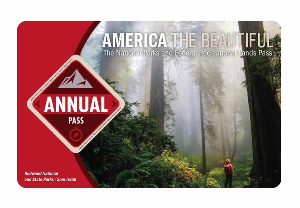
It costs $80 for a yearly America the Beautiful Pass. This gives you access to all national parks and federal areas that charge fees. The America the Beautiful Pass is well worth it!
I purchased my first one in 2016 and it’s such a money-saver! Plus 10% of sale proceeds go to the National Park Foundation.
Tips for Visiting Grand Teton National Park
Grand Canyon National Park is perfect for outdoor enthusiasts. There is something for everyone on this list and for different fitness levels. Also, note that it is dry and hot (in the summer), and make sure you know what you are getting into before you start. Here are a few tips for visiting the Grand Canyon:
- Bring a reusable water bottle and lots of water! Remember you are in the sun and you will need to drink lots of water. I love my LifeStraw Filtered Water Bottle. I can refill this bottle anywhere and it comes with a carabiner to connect it to my daypack.
- Check the Weather – days over 100 degrees are very common. Make sure to check.
- Hiking boots or sandals that will protect your feet! I love good shoes. I need all the support and help I can get. I actually love these sandals for hiking and also love these hiking boots.
- Bring hiking poles for balance and to protect your knees. I know many experienced hikers (and even amateur ones) think that hiking poles are for old people who lose their balance. Actually, hiking poles can help when going down steep inclines or when scrambling over rocks. They are great to hike with even for the most experienced hiker.
- Wear a sunhat. I feel like this whole post is about how high you are in the mountains and how much closer you are to the sun but it is so true. At elevation, you are closer to the sun and more likely to burn. Wear sun protection such as a sun hat and sunscreen.
- Be aware of the wildlife. This is the Southwest and you will need to watch out for snakes and other wildlife such as moose or a bear. Please stay away from wildlife and do not feed them. I recommend carrying bear spray as well.
- Start Early – If you want to avoid the traffic and the heat you will need to start your hike early. That way it will be nice and cool and the smog will not affect you either.
- Leave no trace. If you are new to the concept of Leave No Trace it is all about preserving the environment to ensure it is in the same or better condition when you leave it. This means that you should stick to the trails and carry out everything that you carried in. This is a great explanation of the Leave No Trace principles!
- Water shoes are great for water hikes– If you don’t have a pair, I highly suggest it as they are affordable. I have an article on the pros and cons of several pairs of water shoes.
- Bring Bug Spray and a snack: Be sure to bring everything you need including a snack like a protein bar plus BUG SPRAY.
Where to stay near Grand Canyon National Park
The Grand Canyon makes for a great weekend escape. Fresh air, beautiful scenery and being in nature does a world of good for the soul. I recommend staying as close to the park as possible and even treating yourself with a cabin with a spa pool to relax at night.
- There are lots of fantastic Airbnbs near the Grand Canyon. I have made a list of the best airbnbs around the park wherever you decide to stay. You can also check out my post on Where to Stay near the Grand Canyon to find the perfect hotel for any budget.
If you are taking a road trip remember to reserve a car in advance using Discover Cars .
Tips for Renting a car for your road trip
It’s awfully hard to get to Canyonlands National Park without a car. The closest airport is Las Vegas and you can use Discover Cars to rent a car for your travels. You’ll be able to pick up a car at any airport or in your hometown.
Check availability and get a quote for a rental car for your trip here.
Tips for Visiting in Canyonlands National Park
Canyonlands is perfect for outdoor enthusiasts. There is a hike for everyone on this list and for different fitness levels. Also, note that it is dry and hot (in the summer), and make sure you know what you are getting into before you start. Here are a few tips for Canyonlands hiking:
- Bring a reusable water bottle and lots of water! Remember you are in the sun and you will need to drink lots of water. I love my LifeStraw Filtered Water Bottle. I can refill this bottle anywhere and it comes with a carabiner to connect it to my daypack.
- Check the Weather – days over 100 degrees are very common. On top of that there is quite a bit of air pollution in Phoenix which can make it suffocating. Make sure to check.
- Hiking boots or sandals that will protect your feet! I love good shoes. I need all the support and help I can get. I actually love these sandals for hiking and also love these hiking boots.
- Bring hiking poles for balance and to protect your knees. I know many experienced hikers (and even amateur ones) think that hiking poles are for old people who lose their balance. Actually, hiking poles can help when going down steep inclines or when scrambling over rocks. They are great to hike with even for the most experienced hiker.
- Wear a sunhat. I feel like this whole post is about how high you are in the mountains and how much closer you are to the sun but it is so true. At elevation, you are closer to the sun and more likely to burn. Wear sun protection such as a sun hat and sunscreen.
- Be aware of the wildlife. This is the Southwest and you will need to watch out for snakes and other wildlife such as moose or a bear. Please stay away from wildlife and do not feed them. I recommend carrying bear spray as well.
- Start Early – If you want to avoid the traffic and the heat you will need to start your hike early. That way it will be nice and cool and the smog will not affect you either.
- Leave no trace. If you are new to the concept of Leave No Trace it is all about preserving the environment to ensure it is in the same or better condition when you leave it. This means that you should stick to the trails and carry out everything that you carried in. This is a great explanation of the Leave No Trace principles!
- Water shoes are great for water hikes– If you don’t have a pair, I highly suggest it as they are affordable. I have an article on the pros and cons of several pairs of water shoes.
- Bring Bug Spray and a snack: Be sure to bring everything you need including a snack like a protein bar plus BUG SPRAY.
15 Epic Things to do in Canyonlands National Park
Visitor Center View Point
The 1,000-foot drop around the mesa will be your first look at Canyonlands and the Island in the Sky. It’s a fantastic place to start your visit to the park.
The visitor center, which has maps, brochures, and public facilities, is located as you enter the park. The tourist center’s most startling feature is that it is directly across the street from a stunning outlook.
The Island in the Sky Visitor Center is open seven days a week from spring to fall and five days a week from winter to spring. Seasonal hours vary. Exhibits, book and map sales, backcountry permits, picnic areas, general information, wireless internet, and park rangers on duty are among the amenities available. You can also view a video about the park. Water is accessible all year at the visitor center.
Mesa Arch
Mesa Arch, one of Canyonlands National Park’s most iconic vistas, is a great trail for novices, families with small children, or light hikers. It’s simple and quick, and a clear trailhead display explains how to hike it.
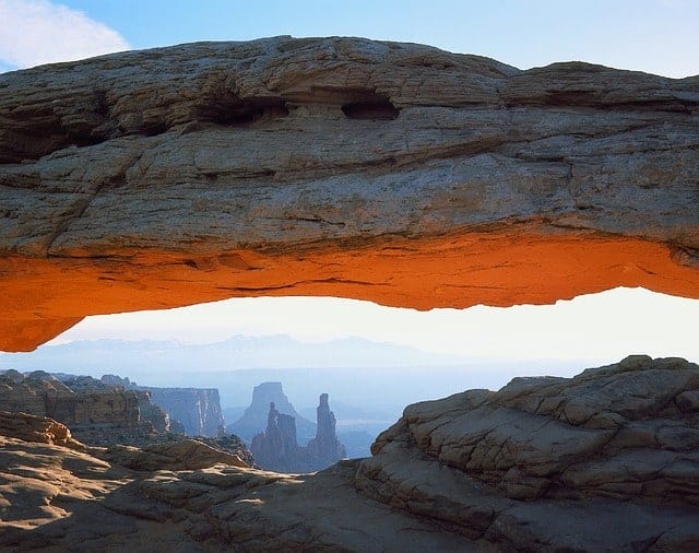
The arch stands on the edge of a 500-foot precipice that drops 1,200 feet into Buck Canyon. Through the arch, you may get a keyhole view of White Rim Road. The arch can also be used to frame the lofty La Sal Mountains which are usually snow-capped in the spring.
The track is well-marked and has some slick rock sections. It’s a short hike, but if you’re taking children, keep an eye on them at the arch. There is no fence to prevent a sure-to-be-fatal fall. Climbing on the arch is not recommended.
You can see another arch from Mesa Arch Overlook – Washer Woman Arch — off to the left when facing the arch. Mesa Arch is a pothole arch because it was created by surface water pooling on the sandstone behind the arch and slowly eroding the rock. The result is a dangling arch across the edge of the mesa.
The arch is lovely at any time of day, but you’ll be in for a spectacular display if you visit during sunrise or sunset. After leaving the arch, return to the trailhead around the loop for a 0.7-mile hike with 75 feet of elevation gain. You’ll get a wonderful glimpse of Aztec Butte rising above the mesa beyond the parking lot on your way back.
Grand Viewpoint
Grand View Point offers a spectacular view of the Canyonlands area. You can see distant mountains, canyons, basins, and the White Rim Road from the viewpoint at 6,080 feet elevation.
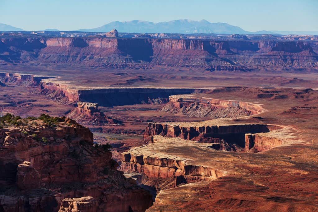
Follow a paved 100-yard trail (91 m) from the parking area to get to the first viewpoint. This trail is wheelchair accessible. At the viewpoint, rangers frequently give geology talks, and there are outdoor exhibits that describe the vista.
The Needles, Monument Basin, the La Sal Mountains, the Abajo Mountains, and the White Rim Road are all visible from the viewpoint outdoor exhibits.
The geological layers that makeup Canyonlands National Park are depicted on panels at Grand View Overlook. The Colorado River is a master landscaper, cutting a 1,000-foot trench into the ground.
The White Rim is the following layer. The hue of this remarkable decoration comes from salt collected in the soil and flows along the tops of the canyons. A thousand feet above the rim, the top of the mesa offers a panoramic view of the area.
An unpaved trail goes another mile (1.6 km) beyond the concrete sidewalk, downstairs, and around the uneven ground and cliff edges to a second viewpoint. Hike the lengthier trail in roughly 90 minutes roundtrip.
The southernmost point of the Island in the Sky scenic route is Grand View Point. The tourist center is about a 15-minute drive away, while Moab, Utah is about a 60-minute drive away. The overlook has restrooms, but no running water. Water is available at the tourist center from spring until October.
Green River Overlook
In Canyonlands National Park’s Island in the Sky District, the Green River Overlook is located at the end of the paved road just past the Willows Campground. The vantage point, at roughly 6,000 feet, provides an excellent view of the canyon amid the canyon geology that distinguishes the Island District. The Green River may be seen winding its way through the vast Soda Springs Basin. The White Rim Trail can also be seen far below.

This is a must-do when visiting the Islands in the Sky District because of its ease of access and vast perspective. Visit an hour after sunrise or after sunset for the finest experience and lighting. This enables the sun to streak above the canyon’s rolling hills, casting beautiful highlights and shadows.
A parking lot makes for a relaxing visit, while large RVs may struggle to navigate the tight corners. A pit toilet is also available. As with the rest of the park, there is no running water except here away from the visitor center.
Be sure to take enjoy this breathtaking view! The view from this vantage point is spectacular, stretching for hundreds of miles. Some dazzling slivers of the Green River can be seen flashing through the canyon.
Late afternoon or close to dusk is the finest time to photograph the Green River since the late sun illuminates the canyon’s west-facing cliffs. Many photographers believe that reflected light enriches the Colorado Plateau by bringing out the soft reds of the canyons.
Shafer Canyon
Shafer Canyon Overlook is located in Canyonlands National Park’s Island in the Sky section, just off Grand View Point Road. Because of its proximity to the visitor center, the overlook is a popular site. Even if it is crowded, the spectacular vistas are well worth the journey.
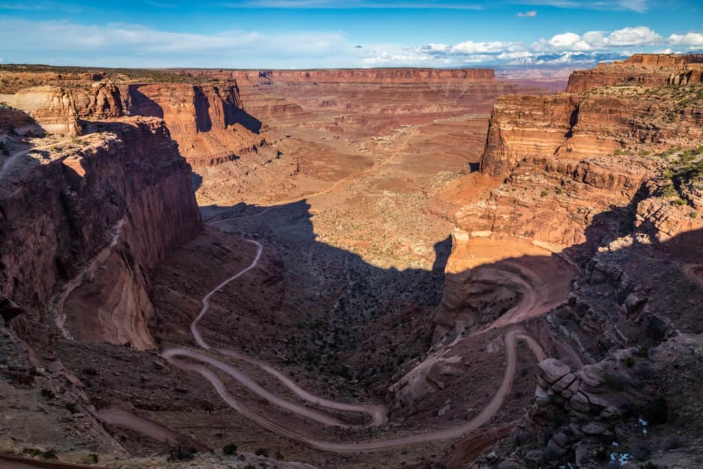
The Shafer Trail in Canyonlands National Park’s Island in the Sky region is an iconic route that drops 1,500 feet (457 meters) through a colorful, enormous sandstone cliff. Its function has evolved over the years.
From a Native American trail to access resources on the mesa top, to a trail for sheepherders moving flocks to better feeding in the winter, to a road for trucks transporting uranium from the wilderness to market, there’s something for everyone.
The Shafer Trail is currently a tough, unpaved backcountry road for adventure seekers seeking a once-in-a-lifetime adventure.
Buck Canyon Overlook
Buck Canyon Overlook is located in Canyonlands National Park’s Island in the Sky section, just off Grand View Point Road. Buck Canyon is less popular than some of the other sights in the area, but don’t expect it to be deserted.
The viewpoint is simply a short walk from the parking area, which is reached through a paved walkway. There are some amazing vistas down into Buck Canyon. The La Sal Mountains rise out of the red canyon rock, and in the distance, you can see the Colorado River and the popular 4WD White Rim Road.
You might be able to make out all the faint outlines of some more roads and seismic lines down in the canyon. These were constructed in the 1950s as part of a search for uranium and oil. Even though these mining activities have been halted for a long time, their impacts are still visible. Natural revegetation is gradually repairing these problems, although it will take a long time in this arid climate.
Upheaval Dome
Upheaval Dome is an impact formation in Canyonlands National Park southwest of Moab, Utah, in the United States. It is the highly eroded bottom-most remnants of an impact crater. The crater is located in the park’s Island in the Sky region, and it’s about 42 miles from Moab by vehicle.

Upheaval Dome in Canyonlands National Park’s most perplexing geological structure. A 1.7-mile climb along the rim of this three-mile-wide, 1,000-foot-deep crater leads to two viewpoints. Upheaval Dome’s origins are the subject of two geological theories, which you can learn about along the trail.
Over a three-mile (5-kilometer) span, rock layers of Upheaval Dome have been extensively distorted. At the center, the rocks are pushed up into a circular structure called a dome, or anticline. This dome is surrounded by a syncline, which is a downwarp in the rock layers.
A wide route leads to the right from the trailhead before curving uphill into the crater. The elevation of 150 feet over 0.3 kilometers is aided by built-in stone steps. When the trail gets to a fork, turn right and you’ll be on your way to the first Upheaval Dome sight in no time. Return up the sandstone rim after taking in the view. The hike to both views is 1.7 miles round trip, however, if you simply visit the first overlook, it can be trimmed down to 0.6 miles.
To get to the trailhead, drive south approximately 6.5 miles from the Island in the Sky Visitor Center. Turn right onto Upheaval Dome Road after reaching the Mesa Arch turnoff. To get to the end of the road, drive 5 miles. There are restrooms and picnic tables near the trailhead.
Whale Rock
Whale Rock is located in Canyonlands National Park’s Island in the Sky region, west of Moab, Utah. Grand Junction, Colorado is 120 miles away, while Moab, Utah is 32 miles away. Whale Rock is a fun hike for small kids and easy enough for parents to go with their toddlers. Extra caution will be needed to prevent children from going too close to the edge and falling.
Whale Rock is a rounded worn sandstone fin that looks like a massive beached whale washed up on Sky Island. The summit of Whale Rock is reached through a one-mile round-trip trek that gains 250 feet in height and offers spectacular views of Upheaval Dome and the surrounding canyons.
Handrails are provided to assist visitors in reaching the top, where they are rewarded with spectacular views of Upheaval Dome. Many individuals prefer to climb the rock without using the railings.
Hikers are treated to panoramic views of Canyonlands National Park’s Island in the Sky District from the top of the trail. This trail is ideal for children and adults of all skill levels, but it does feature some mild slopes and uneven terrain that may be difficult for some.
To get to the trailhead, drive south approximately 6.5 miles from the Island in the Sky Visitor Center. Turn right onto Upheaval Dome Road after reaching the Mesa Arch turnoff. Drive 4 kilometers to the Whale Rock trailhead parking area on the right side of the road.
White Rim Overlook
This short trail leads to the top of a small and lofty mesa with one of Canyonlands National Park’s best panoramic views. Hikers can enjoy a spectacular view of the White Rim, a layer of white sandstone that forms an abrupt edge over the various canyons below, from the viewpoint. This track is excellent for children and adults of all ability levels, however, it does contain some minor slopes and uneven terrain that may be challenging for some. Keep a tight eye on children near cliff edges.

The climb to White Rim Overlook in Canyonlands National Park’s “Island in the Sky” region affords breathtaking vistas with little effort. Obtaining a parking spot may be the most difficult part of this trek, as parking at the trailhead is quite limited. This does, however, assist to keep crowds off the trail, so you’ll probably only see a few people on your hike.
Begin by hiking down some Slickrock away from the picnic area once you’ve found a parking spot. You’ll soon come to a fork in the trail, where the Gooseberry Trail goes left and falls sharply into the canyon, and the White Rim Trail goes right. Stay on the right track.
As it ventures out onto the ever-narrowing peninsula, the White Rim Trail drops gently. The trail varies between easy-to-follow singletrack and occasional cairn-marked Slickrock portions.
Continue going east until you’ve explored as much of the peninsula as you can. Here you will find breathtaking sights. The Colorado River, the popular 4WD White Rim Road, Monument Basin, and the La Sal Mountains will all be visible.
There are tremendous dropoffs all around the viewpoint area, so proceed cautiously. Return the way you came back to the trailhead once you’ve gotten your fill of photos and enjoyed the scenery.
Aztec Butte
Aztec Butte is a one-of-a-kind hike in Canyonlands National Park’s Island in the Sky section. The trail travels across flat meadows before ascending a steep slope to a dome-shaped butte that rises above the mesa. Alcoves along with the butte’s rim house Puebloan granaries were utilized for storage by the early inhabitants.
Aztec Butte is located in Canyonlands National Park’s Island in the Sky region, west of Moab, Utah. Grand Junction, Colorado is 120 miles away, while Moab, Utah is 32 miles away. Aztec Butte is a five-star trek because of the feeling of wandering around where the ancestral Puebloans formerly lived and labored hunting wildlife and collecting grain from the surrounding area.
Two such granaries are visited on a loop around the summit of Aztec Butte, which also affords wonderful views into Taylor Canyon. A shorter butte with another well-preserved granary is circled by a spur route. This hike is 1.8 miles round trip if you include the second butte, and 1.3 miles if you don’t.
This hike is spectacular, but it is not for the faint of heart. The first two-thirds of the trail is well-defined and on packed sand, but near the end, you’ll trek 200 feet up a difficult Slickrock slope, following cairns. The journey up the slick rock slope to the top of the butte is more difficult than mounting Whale Rock since there are no handrails. Make sure you’ve dressed appropriately.
Once on top, you can see several one- and two-room granaries on the upper butte, and two more on the lower butte. None of these structures should be touched or entered. You can also take in some spectacular views, particularly of the enormous Trail Canyon headwall to the northwest.
Between Aztec Butte and the trailhead, you can trek up and around the summit of a similar butte. If you choose this route, keep an eye out for a track that branches off to the west right before you begin going around the other butte.
White Rim Road
The 100-mile White Rim Road runs around and beneath the summit of the Island in the Sky mesa, offering panoramic views of the area. Mountain biking trips last three to four days, while four-wheel-drive trips go two to three days.
You’ll be able to look up at the Island in the Sky mesa and down into the valleys cut out by the Green and Colorado rivers as you drive. You’ll wind your way along jagged cliff edges, past breathtaking overlooks, around towering buttes, and up and over rocky slopes.
Watch the sunset from your tent and look up into the night sky. The view is fantastic if you are lucky enough to do it on a clear night. Canyonlands is a dark sky park, thus the quantity of stars seen is incredible.
The White Rim Road has a restricted amount of vehicles, the campgrounds are far out, and you can travel for kilometers without seeing another person. This is a fantastic way to get away from the crowds and learn more about the park. If you wish to explore more of this lonely landscape, you can go trekking or drive the short detour roads from the White Rim Road.
Under perfect weather circumstances, the White Rim Road is relatively challenging for high-clearance, four-wheel-drive vehicles. Because of the steep, exposed sections of the Shafer Trail, Lathrop Canyon Road, Murphy Hogback, Hardscrabble Hill, and the Mineral Bottom switchbacks, which need additional caution for both vehicles and cyclists during inclement weather, the White Rim loop is a difficult mountain bike route.
Between summer and fall is the optimum time to attempt the White Rim Road. Even in the fall, however, temperatures can reach over 100 degrees. There is also very little shade along the road. As a result, choose your outfit options carefully.
During the winter, you can attempt the road. It may become impassable due to snow and ice accumulation. Weather, on the other hand, does not just obstruct travel during the winter months; when the Green River rises, the route might become impassable.
Permits are necessary to enter the White Rim Road at any time of year, whether for day or overnight use. Here is where you can apply for overnight permits. You are allotted predefined camping areas with your permit; there is no dispersed camping beside the road.