
Visiting the Grand Canyon in April is a magical time. April is a peaceful time to visit but the crowds are starting to arrive especially over spring break or Easter.
I’ve included all of the things to do in the Grand Canyon in April and tips and tricks for visiting. You can also use the Grand Canyon self guided tour to learn more about the Grand Canyon when you visit.
Weather in the Grand Canyon in April
In April, the daytime maximum temperature is 74 degrees Fahrenheit (22 degrees Celsius), while the overnight minimum is 48 degrees Fahrenheit (9 degree Celsius). The Grand Canyon covers a huge area and each section has a varied temperature.
Dress in layers and you will be fine!
Thank you for supporting this website written by an American. This post may contain affiliate links. This means I earn a small commission on these links at no extra cost to you.
National Park Entrance Fees
To enter the National Parks, you’ll need to pay an entrance fee or have a National Parks Pass also known as American the Beautiful Pass.
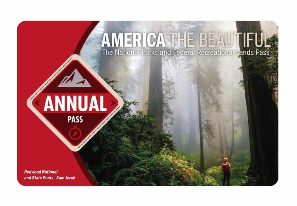
It costs $80 for a yearly America the Beautiful Pass. This gives you access to all national parks and federal areas that charge fees. The America the Beautiful Pass is well worth it!
I purchased my first one in 2016 and it’s such a money-saver! Plus 10% of sale proceeds go to the National Park Foundation.
Tips for Visiting Grand Teton National Park
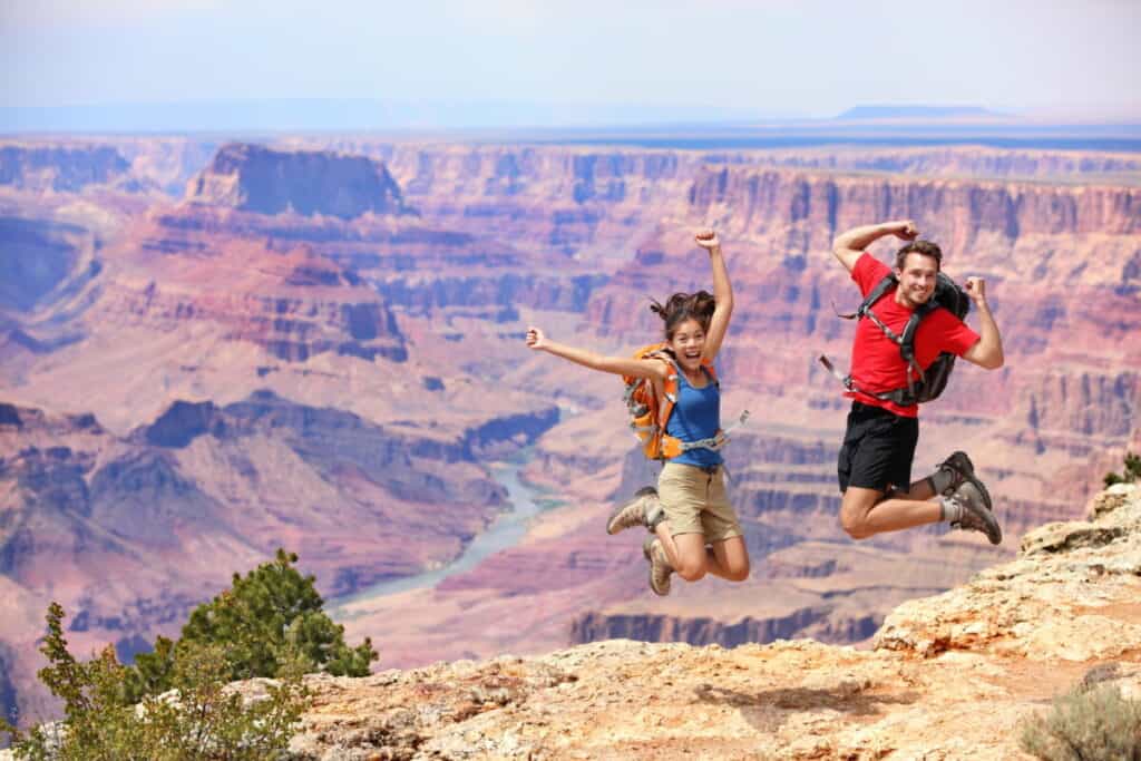
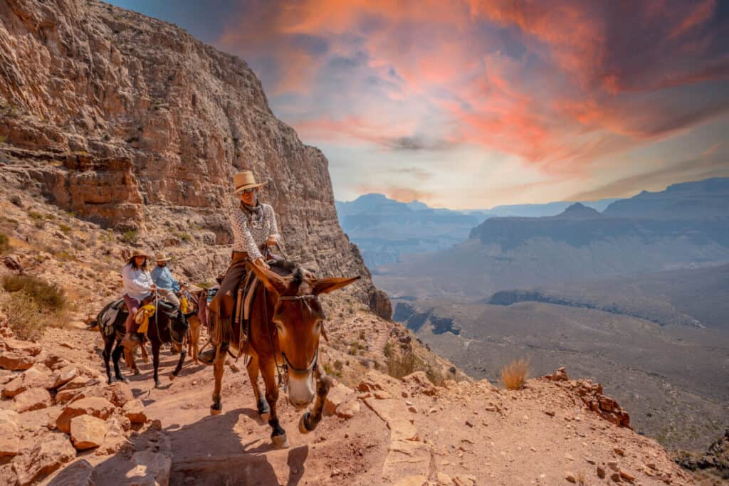
Grand Canyon National Park is perfect for outdoor enthusiasts. There is something for everyone on this list and for different fitness levels. Also, note that it is dry and hot (in the summer), and make sure you know what you are getting into before you start. Here are a few tips for visiting the Grand Canyon:
- Bring a reusable water bottle and lots of water! Remember you are in the sun and you will need to drink lots of water. I love my LifeStraw Filtered Water Bottle. I can refill this bottle anywhere and it comes with a carabiner to connect it to my daypack.
- Check the Weather – days over 100 degrees are very common. Make sure to check.
- Hiking boots or sandals that will protect your feet! I love good shoes. I need all the support and help I can get. I actually love these sandals for hiking and also love these hiking boots.
- Bring hiking poles for balance and to protect your knees. I know many experienced hikers (and even amateur ones) think that hiking poles are for old people who lose their balance. Actually, hiking poles can help when going down steep inclines or when scrambling over rocks. They are great to hike with even for the most experienced hiker.
- Wear a sunhat. I feel like this whole post is about how high you are in the mountains and how much closer you are to the sun but it is so true. At elevation, you are closer to the sun and more likely to burn. Wear sun protection such as a sun hat and sunscreen.
- Be aware of the wildlife. This is the Southwest and you will need to watch out for snakes and other wildlife such as moose or a bear. Please stay away from wildlife and do not feed them. I recommend carrying bear spray as well.
- Start Early – If you want to avoid the traffic and the heat you will need to start your hike early. That way it will be nice and cool and the smog will not affect you either.
- Leave no trace. If you are new to the concept of Leave No Trace it is all about preserving the environment to ensure it is in the same or better condition when you leave it. This means that you should stick to the trails and carry out everything that you carried in. This is a great explanation of the Leave No Trace principles!
- Water shoes are great for water hikes– If you don’t have a pair, I highly suggest it as they are affordable. I have an article on the pros and cons of several pairs of water shoes.
- Bring Bug Spray and a snack: Be sure to bring everything you need including a snack like a protein bar plus BUG SPRAY.
Where to stay near Grand Canyon National Park
The Grand Canyon makes for a great weekend escape. Fresh air, beautiful scenery and being in nature does a world of good for the soul. I recommend staying as close to the park as possible and even treating yourself with a cabin with a spa pool to relax at night.
- There are lots of fantastic Airbnbs near the Grand Canyon. I have made a list of the best airbnbs around the park wherever you decide to stay. You can also check out my post on Where to Stay near the Grand Canyon to find the perfect hotel for any budget.
If you are taking a road trip remember to reserve a car in advance using Discover Cars .
15 Things to do in the Grand Canyon in April
Grand Canyon South Rim: Self-Guided Tour
See a natural wonder of the world in person on this self-guided driving tour of the Grand Canyon’s South Rim.

This self-guided driving tour takes you to all the best vistas, hikes, and attractions along Grand Canyon’s South Rim and tells you the secret history behind this famous landscape. Walk the scenic South Rim Trail, catch a sunset at Mather Point, and much more.
Trail of Time
One of the most fantastic interactive activities in the Grand Canyon is called The Trail of Time, which allows you to fully comprehend the canyon’s incredible development over billions of years. The fully accessible, paved trail begins directly beside the Yavapai Geology Museum.
The first 150 yards or so of the trail span a period of a million years. The second section, which is around 2.8 miles in length, takes you through 2 billion years of history. On the second section of the trail, each meter corresponds to one million years in the Grand Canyon’s geologic past.
You can get sweeping vistas of the canyon while hiking the trek, which lasts around an hour.
Rim Trail
The Rim Trail begins at the South Kaibab Trailhead, a few miles east of Grand Canyon Settlement, and ends at the well-known Hermit’s Rest viewpoint, west of the settlement.
The Rim Trail is around 12 kilometers long in all. The town and other destinations along the trail are conveniently accessible because of a paved road that runs alongside the trail and is used by the park’s free shuttle bus.
The Rim Trail begins a few miles east of Grand Canyon Settlement at the South Kaibab Trailhead and concludes at the well-known Hermit’s Rest viewpoint west of the settlement. The Rim Trail spans around 12 kilometers in total. Luckily, a paved road runs beside the route where the park’s free shuttle bus runs, making it straightforward for visitors to reach the village and other destinations across the path.
The trail gave passengers various experiences, from bustling tourist spots to more isolated portions that let them return to nature. Since there is only water available at Grand Canyon Village, Yavapai Point, and Hermit’s Rest, you should bring a lot of water. You can visit the route without paying anything at the park entrance.
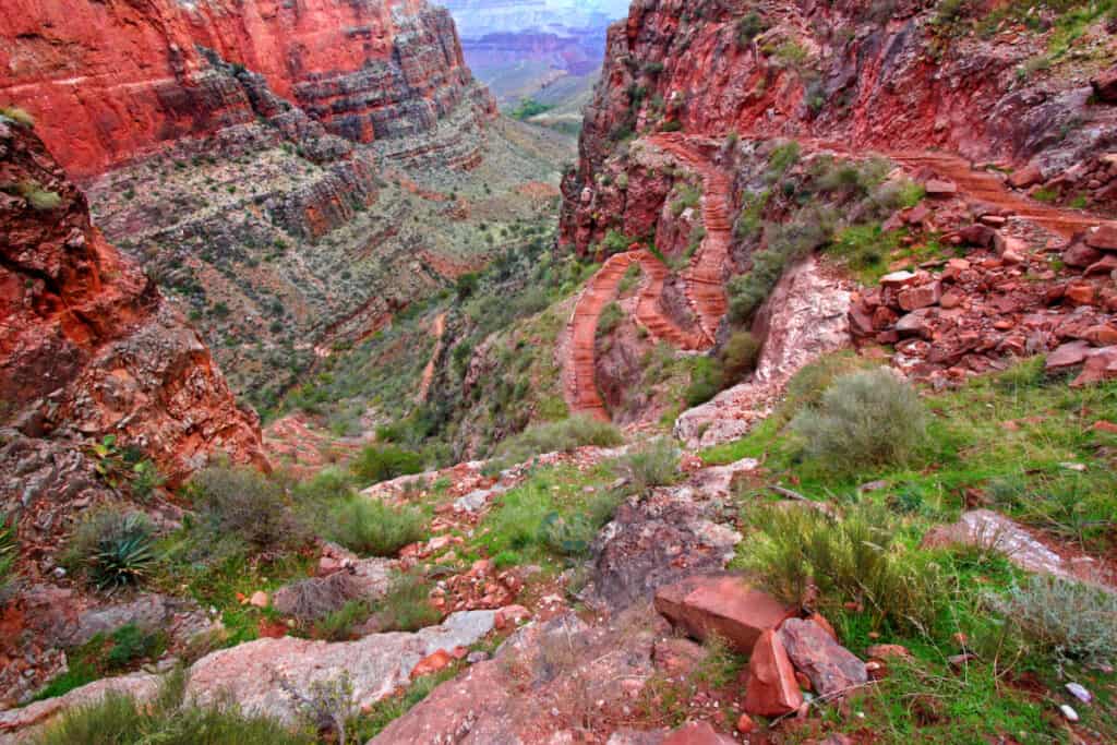
South Kaibab Trail
Another popular hiking path is the South Kaibab Trail, which follows the Grand Canyon’s south rim.
It will probably take twice as long to go back to the starting point because of how steep the terrain is. Since there is limited shade along the trail, it is generally advisable to take this hike in the morning or late in the day.
A beautiful 360-degree panoramic image of the lovely canyon can be seen toward the finish of the trail, which is a little over seven miles long in total. There are several ways to hike only a portion of the trail without losing any of the trail’s splendor, but the views you get along the way are also quite beautiful.
Private vehicles are not permitted if you want to view this for yourself. You will therefore need to take a shuttle bus to the trail’s beginning.
Bright Angel Trail
The Bright Angel Trail is the ultimate Grand Canyon trail and one of the world’s greatest and most famous trails.
Hiking a small portion of this trail should be on everyone’s list of the top things to do in the Grand Canyon.
This trail has been utilized for many years, first by Native Americans, then by miners and pioneers, and ultimately by tourists. A malicious fortune seeker who later became a US Senator once installed a toll gate charging $1 to enter the Bright Angel Trail. That is significantly higher than the height of two One World Trade Centers!
The trail is 8 miles long (almost 10 to Phantom Ranch) and climbs 4,380 feet each way. That is significantly higher than the height of two One World Trade Centers!
Hiking any lengthy (or short) section of this trail is strenuous and should be done with caution. The descent is deceptively simple, but the ascent can be difficult. Water is accessible at the 1.5-mile and 3-mile rest stops, as well as Indian Gardens, which is around halfway to the Colorado River.
Hermit Trail
The Hermit Trail is one of the best hikes along the South Rim, despite being less well-known than the well-traveled Bright Angel Trail.
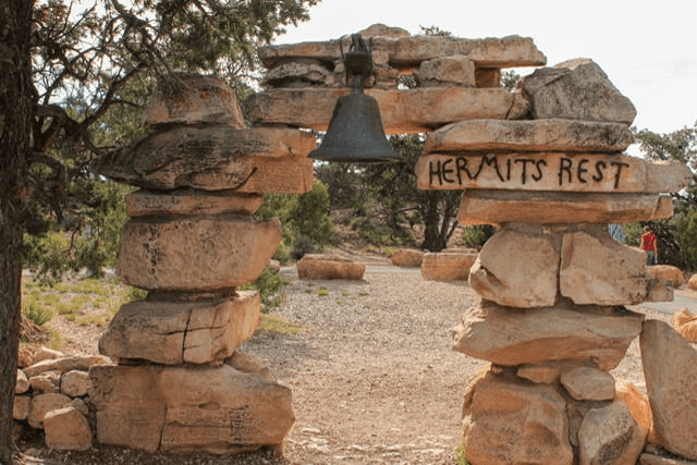
As it descends in two sharp drops to the Colorado River, it treats hikers to breathtaking western panoramas as it leaves Hermits Rest. The Hermit Trail is typically in decent shape despite being unmaintained, with a few challenging but passable washouts.
Santa Maria Spring is 2.5 kilometers away for day hikers (5–8 hours, round-trip). The Hermit Trail comes to an end next to Hermit Rapid, one of the Grand Canyon’s most exhilarating rapids, on the Colorado River’s banks. If you’re lucky, you’ll see river runners tearing over the waves while hooting and hollering.
Backpackers are required to set up camp at one of two designated areas: Hermit Rapid, which is located just west of the Hermit Trail along the Tonto Trail, or Hermit Creek Campsite.
The Hermit Trail begins at the end of Hermit Road, west of Hermits Rest. Day hikers can take the free shuttle to Hermits Rest, while overnight hikers can park at the trailhead (you’ll be given a code to access the gate on Hermit Road).
Grandview Trail
Before the Grandview Trail, which starts at Grandview Point and is accessible by a small side road that descends into the canyon, there are several other views along the South Rim Drive to the east of Yaki Point and the South Kaibab Trail.
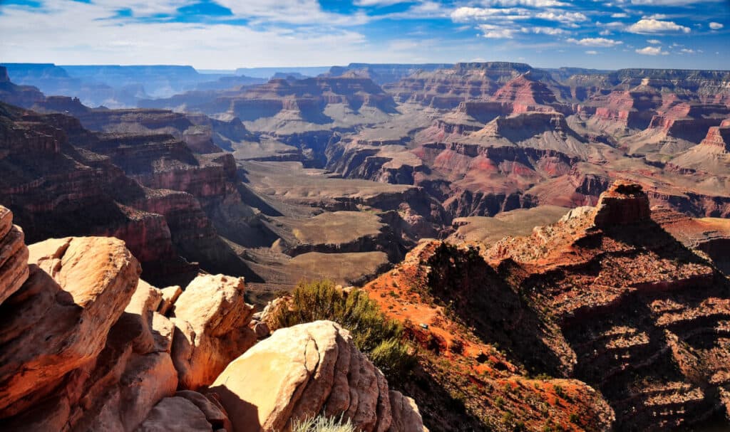
Fine vistas over numerous side ravines and cliffs surrounding the Colorado River may be seen from this 7,400-foot point in all directions.
Even though the trail is small, initially very steep, and only sporadically maintained, it is quite popular, especially the first mile to Coconino Saddle, a viewpoint, but fewer people continue.
Another saddle at the southern edge of Horseshoe Mesa, which is a good candidate for a half or full-day trip and is also the site of some abandoned copper mines and a rustic camping place, is the next destination. This location is 3 miles and 2,500 feet lower than the trailhead.
Unlike the other major paths from the South Rim, the Grandview Trail does not lead to the Colorado River, though this can be reached by challenging, off-trail routes down canyons like Cottonwood Creek and Hance Creek. From here, the Grandview Trail splits into three branches, all of which descend another 1,000 feet or more to intersections with the Tonto Trail, which follows east-west above the river for over 100 miles.
Helicopter Ride
At the Grand Canyon, helicopter tours are accessible all year long. You should experience the vistas of the canyon covered with snow in December.
Even though there are many excursions available, the Grand Canyon Helicopter Tour is among the best. During the 45-minute flight, you will fly over the South Rim and the Kaibab National Forest.
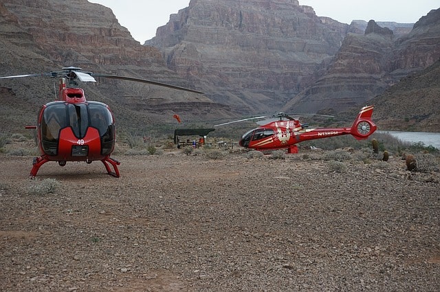
Experience the canyons by looking down into them on a helicopter tour or simply viewing them from a vantage point.
These helicopter rides, though perhaps a bit pricy, are well worth it and will provide you with priceless memories.
Experience the Spirit Helicopter Tour if you want to make this a trip you’ll never forget. The most popular and affordable helicopter tour leaving from the South Rim is this one.
The Spirit Tour, which flies over the Painted Desert, Kaibab National Forest, and—best of all—the Dragon Corridor, the widest and deepest section of the Grand Canyon, gives you some of the best sights, making this experience particularly wonderful.
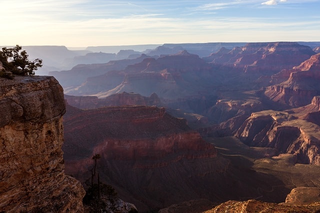
Yavapai Point
Looking for Lake Pleasant’s best vista? Yavapai Point is reached through the Pipeline Canyon Trail, which provides a magnificent experience along the way as well as an amazing 360-degree panorama from the peak.
You won’t be dissatisfied with the variety of routes or the flora and fauna, which range from wider, well-maintained trails across Pipeline to narrower, steeper areas on Yavapai Point. Mexican gold poppies, desert globemallow, and brittlebush are common springtime plants. Additionally, watch out for burros! They can be wandering the nearby hills or on the trail.
To start this hike, park in the Cottonwood Day Use Area parking lot, which is located close to Cottonwood Lane on the west side of Lake Pleasant. On Pipeline Canyon Trail, turn south from this point. Tall signs identify the trailhead and any forks in the route.
When the Pipeline Canyon Trail and the Cottonwood Trail converge, turn left to stay on Pipeline. Following Pipeline will lead you up the slope on the left, through a little wash, and to the next junction. At the next junction, you can choose to continue on Pipeline or turn left to begin the ascent to Yavapai Point.
Although there are some breathtaking views of springtime poppies as you travel further down Pipeline Canyon, Yavapai Point offers the best vantage point.
The trail gets narrower, a little bit rockier, and steeper as it ascends Yavapai Point. Switchbacks, which help to lessen the steepness, swiftly replace the straight section. This short quarter-mile portion is well worth the effort. When you reach Yavapai Point’s peak, you can see Peak 3465 to the west, as well as Hell’s Canyon, Baldy Mountain, and other mountains. North Phoenix will be to the southeast and the Bradshaw Mountains to the north. Naturally, Lake Pleasant is visible to the east.
Take a minute to unwind and take in the scenery if the bench at the top is available. Before you go back down the route, it is a good time for a quick lunch and some water.