Wyoming National Parks: National Parks and National Monuments in Wyoming
Wyoming is a big, wide, beautiful state with two major national parks and seven national monuments. There is a lot to see and do here and the National Parks are some of the most popular ones.
Yellowstone was the first National Park and is mainly located in the state of Wyoming but it also spills over into Montana and Idaho. Grand Teton National Park is located just south of Yellowstone. You can leave the south gate of Yellowstone and drive straight to the gate of Grand Teton making it a great addition to your Yellowstone trip.
And don’t forget about the National Monuments in Wyoming as well. Devil’s Tower is a great stop. Read on to find out more about the National Parks and Monuments in Wyoming.
National Parks in Wyoming
Grand Teton National Park
This Park, which is located at an elevation of 7000 feet above Jackson Hole Valley, spans 31000 acres in Wyoming’s northwest corner and has a 40-mile-long active mountain range. With approximately 100 alpine lakes and the majestic Snake River, the Park is home to moose, bison, grizzly bears, elk, and pronghorn sheep, as well as bald eagles and peregrine falcons.
The Grand Teton region has a long history of human occupation dating back 11, 000 years. The Paleo-Indians were the first to settle in the area and survived by hunting and gathering. The national park also protects a pristine ecosystem, which means that most of the flora and fauna species that existed in prehistoric times are still alive.
Today, you can explore the park’s extensive history and culture through ranger-led programs, visitor centers, and historical points of interest like Mormon Row and the Moulton Barns.
In addition to a fascinating history, Grand Teton’s stunning landscapes and diverse wildlife provide the perfect location for nature lovers and outdoor adventurers.
Hiking, biking, boating, fishing, climbing, horseback riding, cross-country skiing, snowshoeing, and wildlife viewing are the things you can do in the area.
Yellowstone National Park
Yellowstone National Park is one of the oldest national parks in the United States, having been established in 1872. It is a UNESCO World Heritage Site in the Natural category, as well as one of Wyoming’s national park service sites.
Located in Northwestern Wyoming approximately 65 miles north of Jackson Hole, Wyoming. the Park also includes southern Montana and eastern Idaho which enables you to witness the unfolding of nature’s varied mysteries and is open year-round with the majority of visitation in the spring through fall.
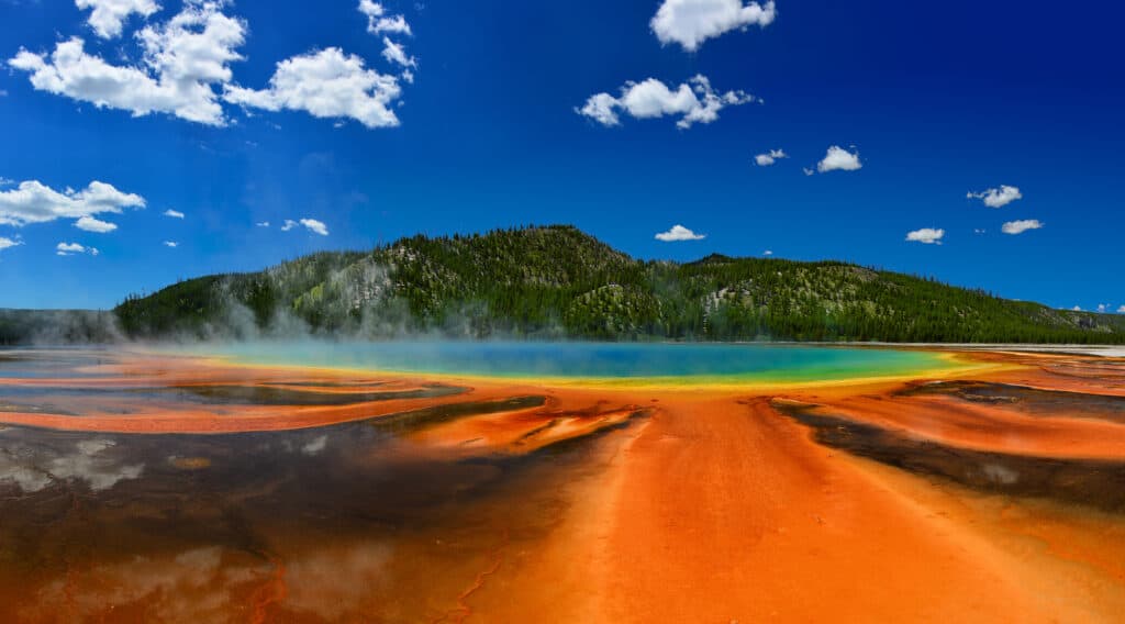
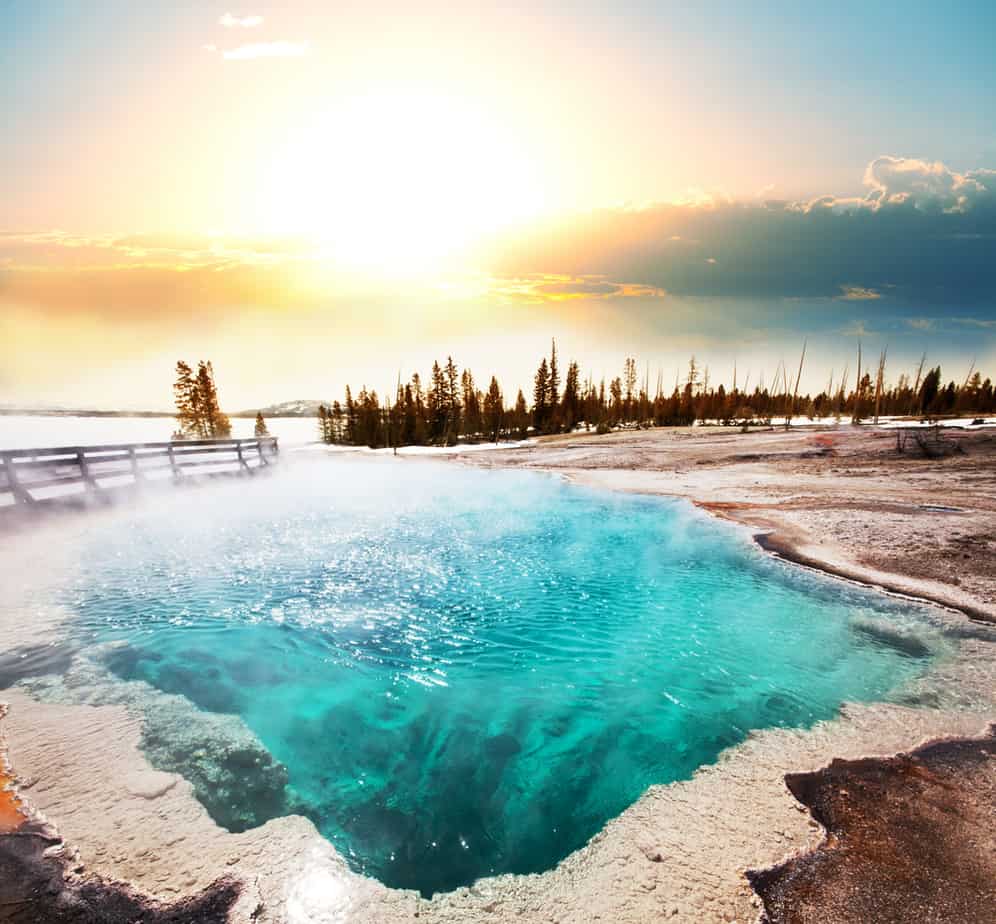
Yellowstone National Park encompasses over 2.2 million acres in a land area spanning five countries: With an average of 4.2 million visitors per year, it is also one of the most popular national parks in the US. Its lakes are among the continent’s greatest high-elevation lakes and best renowned for their geysers, which are one of the region’s most unique geothermal features.
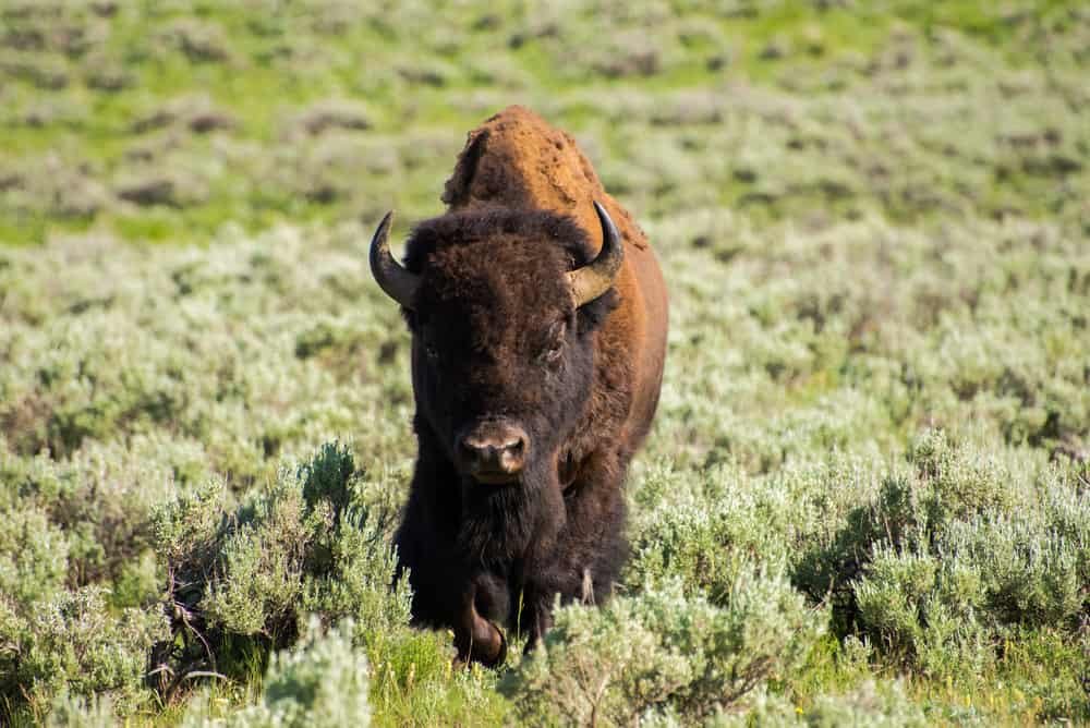
Wolves, bison, elk, grizzly and black bears, bighorn sheep, and other magnificent animals may all be seen in the park. Within the park, there is so much to see and do. This Park has everything for everyone, from geysers and boiling thermal springs to camping and magnificent lodges.
The Old Faithful Geyser is the most popular of all the attractions. Hiking, sightseeing, fishing, boating, and camping are among the recreational activities available to visitors to the park.
National Monuments in Wyoming
Bighorn Canyon
Between the Pryor and Bighorn Mountain ranges, this recreation area crosses northern Wyoming and southern Montana borders, preserving over 68,000 acres. Following the construction of the Yellowtail Dam by the Bureau of Reclamation in 1966, the Park was established to conserve the area’s unique scenery, including the beautiful Bighorn Canyon and Bighorn Lake.

Bighorn Canyon National Recreation Area was established by an act of Congress on October 15, 1966, following the construction of the Yellowtail Dam by the Bureau of Reclamation. This dam was named after the famous Crow chairman Robert Yellowtail, who harnessed the waters of the Bighorn River, and turned this variable stream into a magnificent lake.
Enjoy the tranquil surroundings of Bighorn Canyon National Recreation Area, which offers hiking, horseback riding, and camping opportunities.
Take delight in the gorgeous landscapes frequented by nearly 200 kinds of birds, or learn something new by seeing historic ranches that preserve thousands of years of human history.
The canyon offers a diversified landscape of forest, mountains, upland prairie, deep canyons, broad valleys, high desert, lake, and wetlands. People have also been able to discover calm locations to better explore recreation, nature, animals, and history since the recreation area was established.
Devils Tower
Also known as Bear Lodge Butte, which is a laccolithic butte made from igneous rock within the Bear Lodge Mountains, this national monument is located in Crook County, Wyoming. It is more commonly referred to simply as Devil’s Tower.

This Park was the first US National Monument created. The tower rises 867 feet and has awed people since the first Paleo-Indian travelers came upon it.
President Theodore Roosevelt established the Devil’s Tower National Monument in 1906. The property as a whole is 1,346 acres in size. Because of the sedimentary rocks that make up the majority of the landscape surrounding this monument, it is considered naturally significant. In fact, many of these rocks were studied by archaeologists and traced back to the Triassic period (approximately over 200 million years ago).
Prepare to be amazed: The Devils Tower is a laccolithic butte made up of igneous rocks that rises 867 feet above Wyoming’s rolling prairie and a jaw-dropping geological landmark. This was formed during an igneous intrusion process and receives less than half a million visitors each year.
Today visitors can simply look at the tower, walk the 1.3-mile loop trail around the base, or spend time watching some of the 4,000+ people who climb the tower each year.
After registering with the park’s management, you can either climb the tower’s numerous parallel cracks or take a 1.5-hour ranger-led tour of the mountain. At the Belle Fourche River campground, you may also catch black bullhead and channel catfish. Only bring your supplies to this monument in Gilette, as neither food nor water is sold in the park.
Things that are worth trying when you visit the tower are to hear speakers highlighting a variety of subjects during National Park Service’s Summer Cultural Program or try the Full Moon Walk.
Fort Laramie
This historic site is another entry to the list of national park service sites in Wyoming. It was originally known as Fort William before being renamed, Fort John. During the nineteenth century, this location was a significant trading post. Within the junction of two rivers, the Laramie and the North Platte River was also an important diplomatic site.

To satisfy the need for overland trade at the time, the inaugural trading post was established in 1830. Due to the success of this trading activity and its accompanying businesses, the region swiftly became an economic center of commerce. As a result, the site was designated as a historic site to conserve and preserve its history.
Visit this 19th-century military facility to reminisce about a heroic history of Western expansion and Indian resistance. It was named after Jacques La Ramie, a French-born fur trader, for its early inception as a fur trading post, and it quickly gained prominence as the most well-known military post before being abandoned in 1890.
Currently, the National Park Service manages the site, which includes 22 original structures.
Fort Laramie is located in Southeastern Wyoming approximately 90 miles from Cheyenne. The Park is open spring through fall and offers the opportunity to explore a historic fort, hiking trails, fishing, and taking part in interpretive programs
Fossil Butte
This national monument is located in Lincoln County, Wyoming. Because of its remarkable assemblage of Eocene Epoch animal and plant fossils, it is one of Wyoming’s national park service sites.

The Fossil Lake which is one of the three big lakes is where the fossils are concentrated (and the smallest too). It was only in 1927 that it was designated as a national monument.
The Park also protects one of the world’s richest deposits of Eocene-epoch fossils. The lake sediment has been compressed into rock layers known as the Green River formation.
In addition, the fossils in the Fossil Butte National Monument are widely regarded as the best collection of Cenozoic aquatic species in the world. This area is also part of the Green River formation which is an ancient lake bed.
Millions of fishes, mammals, reptiles, birds, insects, and plants have been found in this formation. The Park protects 12.8 square miles of the area used for visitor enjoyment as well as scientific discovery.
Be sure to visit Fossil Butte’s visitor center with over 300 fossils on display. Visitors can also take a ride along the site’s scenic drive, stop for lunch at a designated picnic area, take a hike around the area or attend a ranger program.
Mormon Pioneer
Located in a one-acre cemetery on First Avenue in Salt Lake City, the Brigham Young Cemetery (also known as the Mormon Pioneer Memorial Monument) is a private cemetery and memorial. It was built in memory of more than 6,000 Mormon pioneers who died between 1847 and 1869 while journeying to Utah from Illinois and other parts of the world. It is where Brigham Young and his legal wife, Mary Angell are buried.

In the year 2000, the cemetery was repaired and redesigned. At that time, two monuments and sculptures honoring two hymn writers were added. Eliza R. Snow, who composed many of the church’s hymns is honored with one of the monuments. She was also the president of the Relief Society for twenty-one years. She was married to Joseph Smith until his death and then married Brigham Young while the other monument is dedicated to William Clayton, the author of the hymn “Come, Come Ye Saints.”
The monument is open to the public daily.
Oregon National Historic Trail
The Oregon Trail is a symbol of American history, marking the path of one of the country’s largest mass migrations. Between 1840 and 1860, historians estimate that 300,000 to 400,000 travelers utilized the 2,000-mile overland route to reach locations in modern-day Oregon, Washington, Utah, and California.

In Oregon, the road passed through the Powder River and Grande Ronde Valleys, across the Blue Mountains, and down the Columbia River to The Dalles, where many wagons and belongings were rafted to the lower Columbia River Valley. Travelers could use the Barlow Road from The Dalles, around Mount Hood, and straight to Oregon City on the Willamette River after 1846.
In addition, the Oregon National Historic Trail is one of nineteen national historic trails in the United States. National historic trails recognize original trails or routes of travel of national historic significance including past routes of exploration, migration, and military action.
The National Historic Oregon Trail Interpretive Center in Baker City, Oregon, is home to almost 500 acres of Oregon Trail terrain, including authentic wagon train ruts and hiking pathways. The story is told through inside exhibitions and an outdoor reproduction wagon encampment.
Other managed sites associated with the Oregon Trail include Birch Creek Interpretive Site, Echo Meadows Interpretive Site, Alkali Springs Interpretive Site, John Day Crossing & McDonald Crossing Oregon Trail Monument, Oregon Trail Fourmile Canyon Historic Site, and Barlow Road Interpretive Sign at Wildwood Recreation Area.
There are many ways to enjoy the Oregon National Historic Trail including auto-touring, visiting interpretive sites, hiking, biking or horseback riding trail segments, and visiting museums. Some or all of these activities may be available depending on which portion you want to explore
In the area, there are no user or entry fees for the Oregon National Historic Trail. Fees may be charged at some trail-related federal, state, or locally owned historic sites and interpretive facilities. The Trail isn’t a typical National Park with campgrounds, lodges, or borders. Many areas may have camping and accommodation reservations available.
Uneven terrain, tripping hazards, and other obstacles can be found on many trails, roads, and locations. If traveling on underdeveloped roads, wear suitable footwear and make sure your tires are in good condition.
Weather can change quickly, especially in mountainous areas at high elevations. It is best to bring layers of clothing, sunscreen, and any other goods that will keep you protected from the elements.
Pony Express
The Pony Express National Historic Trail travels over 1900 miles across eight states: Missouri, Kansas, Nebraska, Colorado, Wyoming, Utah, Nevada, and California. It pays tribute to the Pony Express riders’ usage of the “Old West route” between St. Joseph (Missouri) and San Francisco (California) to transport mail communications in the West.

Before, mail communications took only 10 days which was unprecedented at the time. However, the Pony Express became outdated after 18 months of service due to the invention of the telegraph. Congress established it as a national historic path in 1992.
Here, you can visit trail traces, visitor centers, museums, hiking trails, historic structures, and forts related to the Pony Express National Historic Trail. You can also follow the relay system of the United States’ westward expansion through the entire state of Nevada on the National Park Service’s driving tour.