
15 Best Things to do in Capitol Reef, UT
Capitol Reef Attractions: Are you looking for things to do at capitol reef? Capitol Reef is the forgotten park when it comes to the Mighty 5 in Utah. Most people just drive through Capitol Reef without even stopping but I’m here to tell you that visiting capitol reef national park is well worth your time.
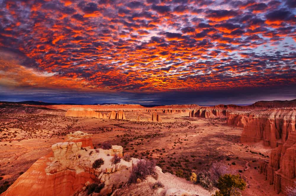
Capitol Reef National Park is located in the desert of southern Utah. With layers of golden sandstone, canyons, and spectacular rock formations, it surrounds the Waterpocket Fold, a lengthy wrinkle in the earth. The Chimney Rock pillar, the Hickman Bridge arch, and Capitol Reef, with its white sandstone domes, are among the park’s highlights. Cathedral Valley, in the north, is known for its colossal monoliths.
Thank you for supporting this website written by an American. This post may contain affiliate links. This means I earn a small commission on these links at no extra cost to you.
National Park Entrance Fees
To enter the National Parks, you’ll need to pay an entrance fee or have a National Parks Pass also known as American the Beautiful Pass.
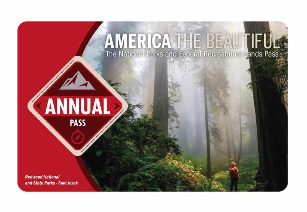
It costs $80 for a yearly America the Beautiful Pass. This gives you access to all national parks and federal areas that charge fees. The America the Beautiful Pass is well worth it!
I purchased my first one in 2016 and it’s such a money-saver! Plus 10% of sale proceeds go to the National Park Foundation.
Tips for Visiting Grand Teton National Park
Grand Canyon National Park is perfect for outdoor enthusiasts. There is something for everyone on this list and for different fitness levels. Also, note that it is dry and hot (in the summer), and make sure you know what you are getting into before you start. Here are a few tips for visiting the Grand Canyon:
- Bring a reusable water bottle and lots of water! Remember you are in the sun and you will need to drink lots of water. I love my LifeStraw Filtered Water Bottle. I can refill this bottle anywhere and it comes with a carabiner to connect it to my daypack.
- Check the Weather – days over 100 degrees are very common. Make sure to check.
- Hiking boots or sandals that will protect your feet! I love good shoes. I need all the support and help I can get. I actually love these sandals for hiking and also love these hiking boots.
- Bring hiking poles for balance and to protect your knees. I know many experienced hikers (and even amateur ones) think that hiking poles are for old people who lose their balance. Actually, hiking poles can help when going down steep inclines or when scrambling over rocks. They are great to hike with even for the most experienced hiker.
- Wear a sunhat. I feel like this whole post is about how high you are in the mountains and how much closer you are to the sun but it is so true. At elevation, you are closer to the sun and more likely to burn. Wear sun protection such as a sun hat and sunscreen.
- Be aware of the wildlife. This is the Southwest and you will need to watch out for snakes and other wildlife such as moose or a bear. Please stay away from wildlife and do not feed them. I recommend carrying bear spray as well.
- Start Early – If you want to avoid the traffic and the heat you will need to start your hike early. That way it will be nice and cool and the smog will not affect you either.
- Leave no trace. If you are new to the concept of Leave No Trace it is all about preserving the environment to ensure it is in the same or better condition when you leave it. This means that you should stick to the trails and carry out everything that you carried in. This is a great explanation of the Leave No Trace principles!
- Water shoes are great for water hikes– If you don’t have a pair, I highly suggest it as they are affordable. I have an article on the pros and cons of several pairs of water shoes.
- Bring Bug Spray and a snack: Be sure to bring everything you need including a snack like a protein bar plus BUG SPRAY.
Where to stay near Grand Canyon National Park
The Grand Canyon makes for a great weekend escape. Fresh air, beautiful scenery and being in nature does a world of good for the soul. I recommend staying as close to the park as possible and even treating yourself with a cabin with a spa pool to relax at night.
- There are lots of fantastic Airbnbs near the Grand Canyon. I have made a list of the best airbnbs around the park wherever you decide to stay. You can also check out my post on Where to Stay near the Grand Canyon to find the perfect hotel for any budget.
If you are taking a road trip remember to reserve a car in advance using Discover Cars .
National Park Entrance Fees
To enter the National Parks, you’ll need to pay an entrance fee or have a National Parks Pass also known as American the Beautiful Pass.
It costs $80 for a yearly America the Beautiful Pass. This gives you access to all national parks and federal areas that charge fees. The America the Beautiful Pass is well worth it!
I purchased my first one in 2016 and it’s such a money-saver! Plus 10% of sale proceeds go to the National Park Foundation.
Tips for Visiting Grand Teton National Park
Grand Canyon National Park is perfect for outdoor enthusiasts. There is something for everyone on this list and for different fitness levels. Also, note that it is dry and hot (in the summer), and make sure you know what you are getting into before you start. Here are a few tips for visiting the Grand Canyon:
- Bring a reusable water bottle and lots of water! Remember you are in the sun and you will need to drink lots of water. I love my LifeStraw Filtered Water Bottle. I can refill this bottle anywhere and it comes with a carabiner to connect it to my daypack.
- Check the Weather – days over 100 degrees are very common. Make sure to check.
- Hiking boots or sandals that will protect your feet! I love good shoes. I need all the support and help I can get. I actually love these sandals for hiking and also love these hiking boots.
- Bring hiking poles for balance and to protect your knees. I know many experienced hikers (and even amateur ones) think that hiking poles are for old people who lose their balance. Actually, hiking poles can help when going down steep inclines or when scrambling over rocks. They are great to hike with even for the most experienced hiker.
- Wear a sunhat. I feel like this whole post is about how high you are in the mountains and how much closer you are to the sun but it is so true. At elevation, you are closer to the sun and more likely to burn. Wear sun protection such as a sun hat and sunscreen.
- Be aware of the wildlife. This is the Southwest and you will need to watch out for snakes and other wildlife such as moose or a bear. Please stay away from wildlife and do not feed them. I recommend carrying bear spray as well.
- Start Early – If you want to avoid the traffic and the heat you will need to start your hike early. That way it will be nice and cool and the smog will not affect you either.
- Leave no trace. If you are new to the concept of Leave No Trace it is all about preserving the environment to ensure it is in the same or better condition when you leave it. This means that you should stick to the trails and carry out everything that you carried in. This is a great explanation of the Leave No Trace principles!
- Water shoes are great for water hikes– If you don’t have a pair, I highly suggest it as they are affordable. I have an article on the pros and cons of several pairs of water shoes.
- Bring Bug Spray and a snack: Be sure to bring everything you need including a snack like a protein bar plus BUG SPRAY.
Where to stay near Grand Canyon National Park
The Grand Canyon makes for a great weekend escape. Fresh air, beautiful scenery and being in nature does a world of good for the soul. I recommend staying as close to the park as possible and even treating yourself with a cabin with a spa pool to relax at night.
- There are lots of fantastic Airbnbs near the Grand Canyon. I have made a list of the best airbnbs around the park wherever you decide to stay. You can also check out my post on Where to Stay near the Grand Canyon to find the perfect hotel for any budget.
If you are taking a road trip remember to reserve a car in advance using Discover Cars .
Tips for Visiting in Capitol Reef National Park
Capitol Reef is perfect for outdoor enthusiasts. There is a hike for everyone on this list and for different fitness levels. Also, note that it is dry and hot (in the summer), and make sure you know what you are getting into before you start. Here are a few tips for visiting Capitol Reef National Park:
- Bring a reusable water bottle and lots of water! Remember you are in the sun and you will need to drink lots of water. I love my LifeStraw Filtered Water Bottle. I can refill this bottle anywhere and it comes with a carabiner to connect it to my daypack.
- Check the Weather – days over 100 degrees are very common. On top of that there is quite a bit of air pollution in Phoenix which can make it suffocating. Make sure to check.
- Hiking boots or sandals that will protect your feet! I love good shoes. I need all the support and help I can get. I actually love these sandals for hiking and also love these hiking boots.
- Bring hiking poles for balance and to protect your knees. I know many experienced hikers (and even amateur ones) think that hiking poles are for old people who lose their balance. Actually, hiking poles can help when going down steep inclines or when scrambling over rocks. They are great to hike with even for the most experienced hiker.
- Wear a sunhat. I feel like this whole post is about how high you are in the mountains and how much closer you are to the sun but it is so true. At elevation, you are closer to the sun and more likely to burn. Wear sun protection such as a sun hat and sunscreen.
- Be aware of the wildlife. This is the Southwest and you will need to watch out for snakes and other wildlife such as moose or a bear. Please stay away from wildlife and do not feed them.
- Start Early – If you want to avoid the traffic and the heat you will need to start your hike early. That way it will be nice and cool and the smog will not affect you either.
- Leave no trace. If you are new to the concept of Leave No Trace it is all about preserving the environment to ensure it is in the same or better condition when you leave it. This means that you should stick to the trails and carry out everything that you carried in. This is a great explanation of the Leave No Trace principles!
- Water shoes are great for water hikes– If you don’t have a pair, I highly suggest it as they are affordable. I have an article on the pros and cons of several pairs of water shoes.
- Bring Bug Spray and a snack: Be sure to bring everything you need including a snack like a protein bar plus BUG SPRAY.
How to get to Capitol Reef National Park
We stayed in Hanksville, Utah when we visited Capitol Reef. We had spent the day before at Arches and were continuing on to Bryce Canyon after Capitol Reef.
If you are planning a road trip, below are the driving distances and times for nearby destinations in Utah:
- Bryce Canyon National Park: 120 miles, 1.25 hours
- Goblin Valley State Park: 68 miles, 1.5 hours
- Grand Staircase Escalante: 75 miles, 1.75 hours
- Moab: 144 miles, 2.5 hours
- Zion National Park: 182 miles, 3.25 hours
- Salt Lake City: 225 miles, 3.5 hours – closest airport
- Las Vegas: 327 miles, 5 hours – best airport for a Southwest Road Trip
What to do in Capitol Reef National Park
Sunset Point
The Sunset Point Trail, at only 0.4 miles, is the shortest trek in Capitol Reef National Park, although it is sometimes overlooked because it begins at the end of a short stretch of gravel road. The walk follows the rim of Sulphur Creek’s twisting, 500-foot-deep canyon to a great viewpoint atop a red rock ridge, looking east along the canyon’s lower reaches towards Capitol Reef’s cliffs and domes. This is a favorite spot for watching the sunset because of its lofty location and easterly view.

Capitol Reef by Bruce Straits
Although there is some rocky up and down in the first few hundred yards, the trail to Sunset Point is pretty flat. The trail is lined with beautiful red rocks, yet it is not tough or sandy. There are benches along the way, and because this climb isn’t very popular, you’re likely to have the bench to yourself. As you hike, keep an eye out for the red rocks of the water pocket fold to your left. The path gets its name from the deep, magnificent color that appears near sunset.
Sunset Point is also a wonderful climb to the smallest kids. toddlers and grandparents. They would like this hike even though it is not wheelchair accessible.
The views along the route and from the peak are breathtaking. Don’t miss out on possibly one of the most spectacular sunsets you’ll ever see! Sunset Point got its name from the fact that it is one of Capitol Reef’s best places to watch the sunset.
Capitol Reef Scenic Drive
The Capitol Reef Scenic Drive is one of the top things to do in the park. This paved road is 7.9 miles long (one way) and passes through some of the park’s most beautiful scenery. Scenic Drive runs from Fruita to Capitol Gorge Road.

From the green valley of the Fremont River through the dramatic geologic upheaval of the Waterpocket Fold in Capitol Reef to the wild shale and sandstone high desert mesas and buttes that spread out to the north of the rugged Henry Mountains, this drive along Utah Highway 24 from Loa to Hanksville and through Capitol Reef National Park is nonstop knockout scenery. The distance between Loa and Hanksville is about 75 miles.
Allow at least half a day to explore around Capitol Reef, and longer if the area reignites your attention, for this entire scenic drive. Some wonderful side diversions might make this drive even longer.
A paved road on the right, five miles east of Bicknell, leads a mile or so to the delightful little hamlet of Teasdale, a wonderful detour to see a fine example of a traditional Mormon farming town. Along Highway 24, keep an eye out for deer. The town of Torrey serves as a gateway to both Capitol Reef National Park and the mountain wildness of the Aquarius Plateau’s eastern slope.
Explore the best of Capitol Reef, side trips, and nearby drives.
Highway 24
The main road that travels through the park is Highway 24. Within the park’s limits, this route goes east-west for 16 kilometers, following the Fremont River.
Highway 24 is a very beautiful stretch of road. The road twists and turns along the Fremont River in the east, passing huge domes and Navajo sandstone cliffs. The views open out as you approach Fruita, as you drive through a valley filled with orchards and ancient houses along the Fremont River. You’ll drive across massive red sandstone mountains, cliffs, and rock formations as you continue west into Torrey.
Highway 24 has no entrance fee, thus you can visit this area of Capitol Reef without paying. Sunset and Panorama points, the petroglyphs, and a few hiking routes are all part of this “no fee zone” of Capitol Reef.
Capitol Reef Petroglyphs
Capitol Reef is home to several ancient petroglyphs, which are carved etchings in rock walls, as well as towering sandstone structures and magnificent canyons. Between 600 and 1300 A.D., Fremont and Ancestral Puebloan people lived here, and their markings reveal what appear to be their life stories, hunting routines, agricultural cycles, and mythology.

James St. John
You can look at the stunning renderings and make inferences about a variety of forms, including anthropomorphic (human-like) characters, wildlife, birds, tools, and more esoteric, abstract objects. The Fremont people were more prolific with their rock art than other Native American tribes in the area.
On Highway 24, 1.5 miles east of the visitor center, the most immaculate example of Capitol Reef petroglyphs may be found. The turnout for parking is marked. The stunning petroglyph panel is only a short walk down the boardwalk. Animals they hunted, as well as human-like beings with extravagant horned headdresses, may be seen.
The Fremont culture explored this very landscape that you are exploring, looking for food, charting natural and temporal patterns, maybe passing on medical knowledge, and using petroglyphs to communicate and translate the divine.
You should avoid touching the panels since the oils on your hands can harm and degrade these priceless and ancient works of art. If you notice someone destroying rock art or any archeological site, call a ranger right away.
Cathedral Valley
Cathedral Valley in Capitol Reef National Park’s rough and secluded northern sector. Few people make the trip out this distance to witness the sandstone monoliths, colorful Bentonite hills, and immense desert beauty of this valley. But that’s part of what makes it so appealing. The Cathedral Valley Loop is a fantastic drive to add to your bucket list if you enjoy getting away from the people and exploring the backcountry.

Kevin Neubauer
You and your travel companions may find yourself alone in a rugged and beautiful region if you have a sense of adventure and a high-clearance vehicle. Get permission and spend the night, and you’ll be gazing up in wonder at enormous monoliths stretching towards starry heavens. Because of its striking resemblance to Temples and various Cathedrals with Gothic architectural characteristics, the valley was given this name.
This route delights people who believe themselves to be environmental and cultural lovers due to its views. Visitors can take a self-guided ‘road trip’ on the trail, which is open all year! The route is around 60 miles long, and there is no cost to drive it
The fascinating Temple of the Sun and Temple of the Moon, two massive rock structures are seen from the Upper Cathedral Valley Trail, are the most popular stop on this trail.
Waterpocket Fold
Capitol Reef National Park is defined by the Waterpocket Fold, a notable geologic feature. It’s a nearly 100-mile-long crack in the earth’s surface that runs north-south from Thousand Lake Mountain to Lake Powell. Rocks have been pushed higher along the Fold, and erosion has cut through the strata, resulting in deep narrow gorges and unique formations.

The Waterpocket Fold, like other folds, arose from an underlying fault, in this case during the Laramide Orogeny, a significant mountain-building event that occurred 50 to 70 million years ago.
Due to the sheer rocky terrain, east-west travel across The Fold is difficult; there are only a few places where roads have been pushed through. Highway 24 runs through the park’s middle, providing access to visitor facilities. It’s the sole paved route that connects the Waterpocket Fold to the rest of the world.
With its deep erosion and temple-like Entrada sandstone monoliths, the most picturesque aspect of the Capitol Reef landmark is visible. The views from the drive are breathtaking. Many areas of the Henry Mountains and the Waterpocket Fold can be seen from your vehicle.
It’s probably better to visit the Waterpocket Fold at least once in your life than to hear about it multiple times because it’s such an ancient and jaw-dropping location!
Hickman Bridge Trail
If you want to go on some short hikes while taking in some breathtaking canyon views, then Hickman Bridge is the place to go during your visit to Capitol Reef National Park!
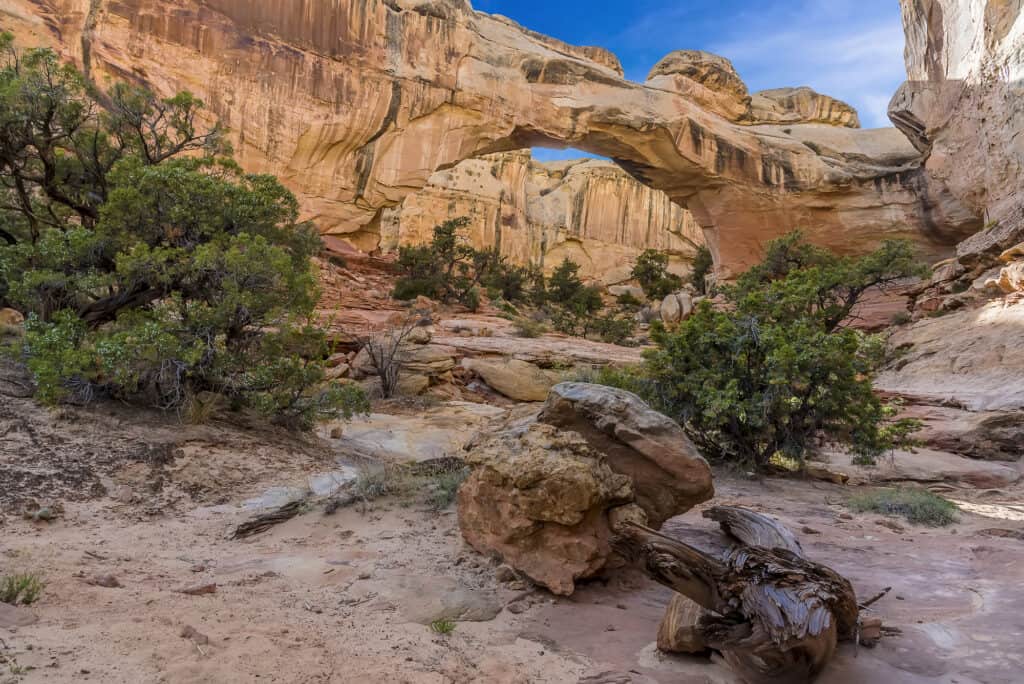
This is a heavily traveled out and back trail near Torrey. The route is best used from March to November. Hiking this trail in June will reward you with a plethora of wildflowers and spectacular views!
If it’s busy, park in the car park or along the side of the road nearby. The trail briefly follows the Fremont River before climbing and becoming a pleasant track to hike. It isn’t just a flat and easy walk the entire way.
Several spots have smooth spherical-shaped imprints in the rock as if the walls had been chiseled out by an ice cream scooper. An enormous natural rock bridge, comparable to many of the structures in Arches National Park, awaits you at the trail’s end.
The orange-colored bridge is striking, and it makes for a great view from below. Try out different angles by moving off the beaten route. This is the hike to take if you only do one in the park.
Cohab Canyon
Cohab Canyon links to the Frying Pan Trail, which connects to the Grand Wash Cassidy Arch Trail, allowing you to take a tour of the Waterpocket Fold’s northern part. The hike is of moderate difficulty and is 1.56 miles (one way).
Cohab is the first canyon south of the Fremont River in Capitol Reef, and it may be reached from either the west or the east, either at the campground or directly over the highway from the Hickman Bridge Trail parking lot.
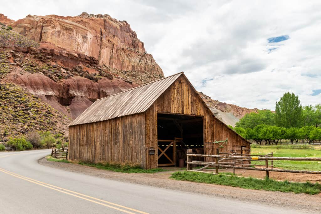
Because of its proximity to both the visitor center and the campground, the western trailhead is the most popular; it has a small parking area near the start of the path, or cars can be parked further back along the road next to an old wooden building (Gifford Barn), which is one of several original structures in Fruita dating from the early twentieth century.
A car shuttle, like several other trails in the park, would be useful to prevent retracing steps, while the other option of a round trip requiring a 3.2-mile walk along the main road between the two trailheads is pleasant enough. The majority of individuals simply stroll from one end to the other and then return in the same direction.
A high-altitude destination Waterpocket Fold in Capitol Reef National Park’s Cohab Canyon is a favorite destination for visitors to the Utah national park. Its lower end runs beside Highway 24 into the gorge, while the upper end leads to Fruita’s historic community. Cohab Canyon is a moderately strenuous hike that is best done from March to November.
Strike Valley Overlook
Capitol Reef National Park’s Strike Valley Overlook is yet another spectacular spot. The Waterpocket Fold may be seen from the overlook, which is perched on a steep sandstone rock. Capitol Reef National Park classifies this trek as easy. Although the climb is safe for healthy adults and children, the site does get fairly hot during the summer.

You’re staring out over one of the water pocket fold’s edges from this vantage point. From here, you can witness about 150 million years of geologic history. As you look out over Navajo and Entrada sandstone, Mancos Shale, Carmel Formation, and several other layers of sedimentary rock, it’s a lovely, colorful site.
This is a remote viewpoint, and accessing it can be challenging. You’ll drive straight by this perspective if you’re planning to Loop the Fold. A 3-mile access road goes to the trailhead from Burr Trail Road. Standard automobiles will only be able to drive a quarter-mile along this route before having to park and walk the remaining distance. High clearance vehicles should be able to get to the parking area, but 4WD may be required in some cases.
The out-and-back hike to Strike Valley Overlook is about 6 miles long and lightly trafficked. It has some lovely wildflowers in it. The trail can be used for hiking, natural adventures, and off-road rides in addition to hiking. March through November is the greatest time to visit.
Pioneer Register
The Pioneer Register, a location on the sandstone wall where early Mormon pioneers engraved their names, is about a half-mile into the Capitol Gorge climb. In 1884, Mormon pioneers cleared the trail through Capitol Gorge in eight days, using the register to keep track of their progress.

This rail was the flattest and easiest hike in Capitol Reef. It has an optional extension to many natural waters “tanks”. It runs a mile out and back. Drive all the way to the end of the picturesque route in Capitol Reef National Park to a large parking space to reach the trailhead.
This trail follows a large, flat wash. There is virtually little elevation rise and the canyon walls provide some morning and evening shade. The trail is well-worn but not particularly rough. This trail has moderate to heavy traffic.
Take a stroll down Capitol Gorge at the end of the Scenic Drive, and look at the north side of the canyon wall approximately half a mile (0.8 km) from the trailhead (left). Take note of the numerous names, dates, and locations carved, painted, and even fired into the sandstone.
Prospectors, explorers, surveyors, cowboys, early settlers, and visitors would frequently stand on their wagons to carve their names into the canyon wall. They were leaving their mark above the threat of flash floods, most likely in the hopes that their names would be remembered for decades.
Capitol Gorge Road
Capitol Gorge, a small, deep canyon carved out of the Waterpocket Fold, is located at the south end of Scenic Drive and the far end of the unpaved 2.4-mile Capitol Gorge Road. The first route through the gorge, which ran from Caineville to Hanksville, took Mormon pioneers eight days to clear in 1884.

The Blue Dugway, as it was known, was a road that connected these small towns until after World War II. Most vehicles (no RVs) can drive into the gorge today, or hike in on the one-mile (one-way) Capitol Gorge Trail, which passes petroglyphs, the Pioneer Register, and the Tanks.
The easy Capitol Gorge Trail, despite being only a one-mile route (one-way), travels through plenty of history in its small distance. Hikers can park their cars at the end of the unpaved Capitol Gorge Road, which was first dug out by Mormon pioneers in 1884, and hike into a deep canyon cut into the Waterpocket Fold.
Hikers will pass some faint petroglyphs dating from the period of the Fremont people on the trail, which is quite level with only 80 feet of elevation increase. A bit further down, the Pioneer Register is a location on the canyon wall where early pioneers engraved their names into the sandstone. Hikers will eventually reach the Tanks, a collection of enormous craters in the sandstone where erosion has formed pockets into the rock that sometimes contain rainfall, after a bit of an upward scramble.
Gooseneck Overlook
The Goosenecks Overlook hike is located in Torrey, Utah, in Capitol Reef National Park. The short route goes from the parking area to an overlook of Sulphur Creek Canyon’s meandering bends hundreds of feet below. As the land was raised when the Rocky Mountains were built, the brook cut its way downhill into the soft rock.

Famartin
Between the parking lot and the canyon, the path begins by rising a slope. The overlook is located on the canyon rim, right below the hill’s summit. Hikers are advised to stay away from the rocks along the rim since they can be dangerous.
Begin walking on the Goosenecks Trail from the parking lot. Before cresting into a rocky hilltop, the trail climbs a brief slope. Following the walk through the boulders, it eventually drops down to a fenced overlook on the canyon’s brink.
The fenced area provides a safe environment for getting a close look at the stunning view of the goosenecks. Sulphur Creek, the river that flows below, is another popular, but much more difficult, Capitol Reef hike. Return the same way you came to the trailhead after taking in the magnificent vista.
Cassidy Arch
Cassidy Arch is located in the center area of Capitol Reef National Park, specifically close to the western walls of Grand Wash, beside the Scenic Drive, and is named for the renowned Butch Cassidy. The arch trail is a tributary of the larger Frying Pan Trail, which climbs northeast above the Waterpocket Fold before dropping into Cohab Canyon and onto Highway 24.

John Fowler
The trail to Cassidy Arch starts with a gentle stroll through Grand Wash. The walk begins at the northeast end of the Grand Wash trailhead parking lot and travels east for 0.1 miles along a bench on the north side of the wash before coming down to and continuing along with the wash. At 0.25 mile, look for a sign identifying the start of the Cassidy Arch and Fryingpan paths on the left (north) side of the wash.
Turn left and follow the Cassidy Arch route as it rises through colorful Wingate sandstone via switchbacks and Slickrock ramps on moderate to severe grades. The trail is now moving west, curving in and out of side valleys and echoing Grand Wash’s features. Soon after, the trail bends to the right around a low knoll. Cassidy Arch, set in a red strip of rock on the west walls of a side canyon, can be seen if you look west.
It should be noted that there is no official route to the arch’s base for the interested traveler. Cassidy Arch is a moderately tough trail that is best used from March to November.
Gifford Homestead
Before the region became Capitol Reef National Park, the Giffords were the last family to live in Fruita. Orchards and the historic Gifford House can be found on the homestead. The house is built in the style and essence of rural Utah farmhouses from the early 1900s. A barn, smokehouse, garden, pasture, and rock walls, as well as a home, are all part of the Gifford Homestead. This is the ideal spot to pick up souvenirs to take home with you.
The Gifford Homestead, one of the last remaining structures in old Fruita, sells dolls, soap, quilts, jams and jellies, and books manufactured by local craftsmen. The pie, however, is the main attraction. They’re famous for their fruit pies created with locally grown produce! Stop in for ice cream and a taste of freshly baked fruit pie. They are not to be missed!
Inside the house, you may purchase delectable baked pies, coffee, scones, and cakes, which you can enjoy on picnic seats right outside the front door, surrounded by a tranquil landscape.
Gifford Homestead is a spot that will wow you with its greenness, especially after viewing the canyons’ red hues!
Chimney Rock Trail
The Chimney Rock Trail, located just inside the west entrance to Capitol Reef along with UT 24, is perhaps the best short path in the national park because it is relatively short, not too steep, provides the shortest hike to a high elevation viewpoint, and passes through varied surroundings, including colorful badlands, tall cliffs, and the mouth of a narrow canyon.

Another route runs down this ravine to the much longer Spring Canyon, which may be followed for many miles either up or downstream, however, most tourists come for the main Chimney Rock Loop, a 3.5-mile adventure with 580 feet of elevation gain that takes about 90 minutes to complete.
The hike starts off very flat but quickly turns into a series of switchbacks leading to the top of the mesa. This is the first of three altitude gain portions on this hike. The trail flattens out a bit until you reach the top of the Mesa, and the views start to get really spectacular. The flat trail doesn’t continue long until the second ascent begins. These inclines will put anyone who isn’t in good shape to the test, but they aren’t too bad.
The trail quickly approaches the base of a tall cliff, which is surrounded by large stones (which have broken off the rock and fallen). After passing through the boulder graveyard, the trail bends sharply east and climbs somewhat until it reaches the loop’s end. On the right, the trail runs parallel to an area of enormous red sandstone cliffs.
In the summer, the trail is entirely exposed with little shade, making it a very hot hike. Always bring plenty of water and wear a hat.