
Arizona National Parks – The Best National Parks and Monuments in Arizona
Arizona has three national parks and 18 national monuments. The Grand Canyon State has a lot to offer in the natural beautiful scenery and amazing sites.
Everyone knows about the Grand Canyon but there are plenty of worthwhile sites to visit in Arizona. I’ve covered all the parks and monuments in Arizona on this list.
National Parks in Arizona
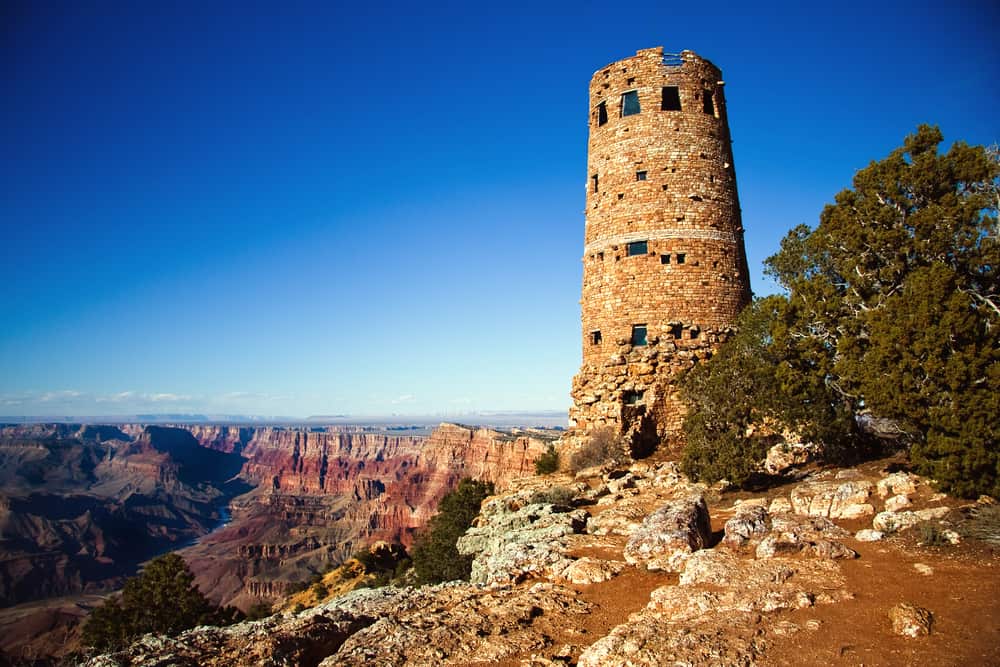
Grand Canyon National Park
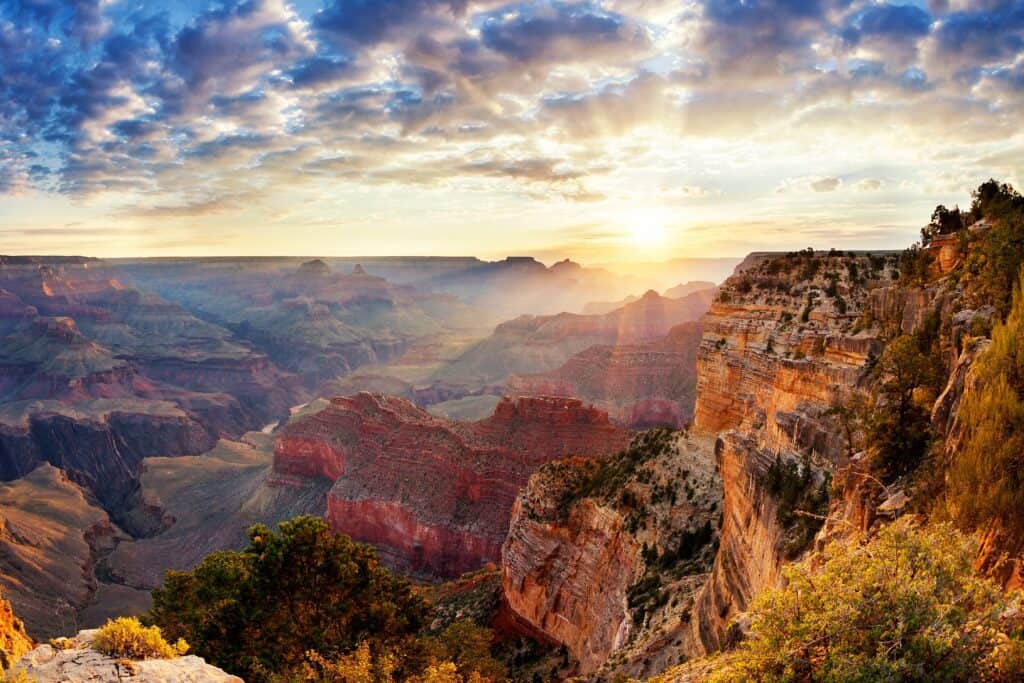
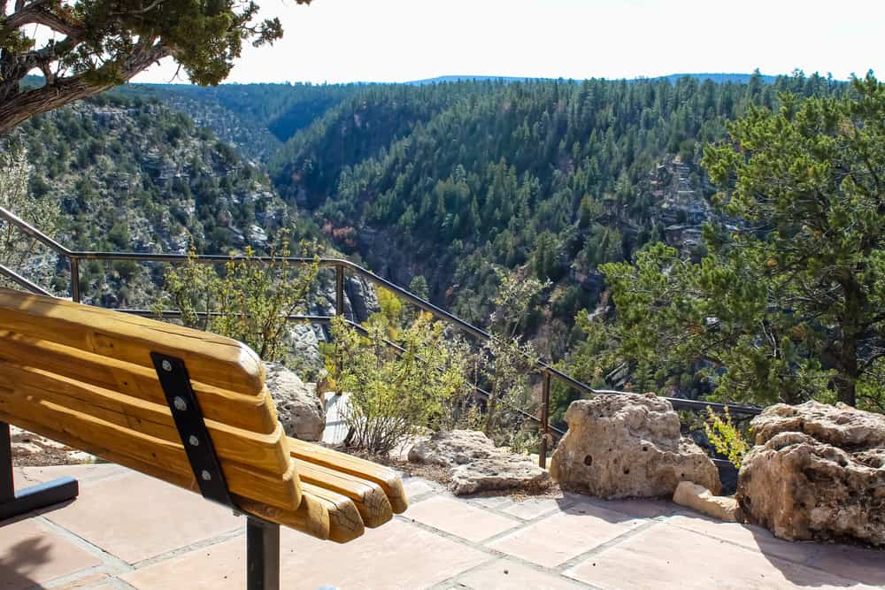
Located in Northwest Arizona, 214-miles west of Flagstaff, Grand Canyon is the biggest canyon in the United States and one of the largest in the world. It extends for over 200 miles along the Colorado River in northern Arizona. Its sheer size is awe-inspiring, but also a stunning record of time.
The Colorado River carved the landscape into sheer rock walls over millions of years, presenting various distinct colors, each denoting a different geologic era. You feel as if you’re seeing deep into the mysteries of the earth when you climb a historic path like Bright Angel, Hermit, or Kaibab, or watch a sunset or sunrise from the rim.
Grand Canyon National Park’s wildlife is often overlooked as a highlight of a visit. The canyon is home to thousands of species, many of which are unique or exceedingly uncommon, from bighorn sheep to small brown bats. It’s also a fantastic area to see California condors. The massive birds, which were once on the verge of extinction, are now gradually making a comeback thanks to smart wildlife management.
The national park features a magnificent Geology Museum and a fantastic Trail of Time exhibition where you can learn more about the canyon’s lovely layered sceneries in addition to revealing in its magnificence and exploring its extraordinary pathways. Widely considered to be one of the Wonders of the World, the Grand Canyon is the highlight of many people’s visits to Arizona.
Check out my post on the Best Things to do in the Grand Canyon National Park
Petrified Forest National Park
Petrified Forest National Park can be found in eastern Arizona, not far from the New Mexico border. It is home to an astounding array of scenery, landscapes, and nature, famed for its fantastic fossils. It also has excellent hiking adventures for visitors to enjoy, as well as cycling, horseback riding, and camping.
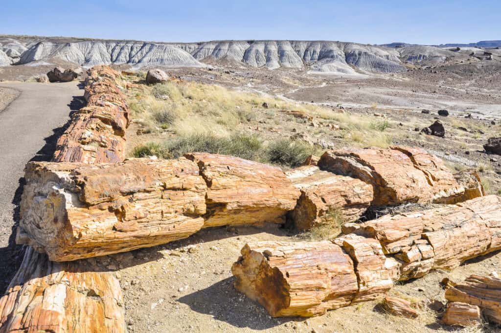
The Park, which was founded in 1906, preserves the amazing remains of the ancient trees and logs after which it is named. The kaleidoscopic colors of the petrified trees, which dated back an almost astounding 225 million years, are gorgeous especially when they glow in the sun.
Most visitors to Petrified Forest National Park come to see the ancient tree trunks, which are preserved by minerals they absorbed after being submerged in a riverbed nearly 200 million years ago. The intriguing badlands, which are home to magnificent archaeological sites and beautiful petroglyphs, are the park’s highlight feature. Visitors can learn about the area’s fascinating history, geology, and environment at the Painted Desert Visitor Center and Rainbow Forest Museum.
Check out my post on the Best Things to do in Petrified Forest National Park
Saguaro National Park
Saguaro is one of the most accessible and attractive national parks in Arizona. It was named after the giant cacti that dot its delightful desert landscapes; the park offers an iconic image of the American Southwest.
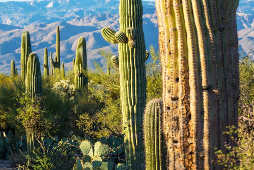
Saguaro National Park is divided into two districts, one west of Tucson and the other east. Summer temperatures are dangerous, so try to avoid them in the mornings and nights of the autumn, winter, and spring. Although there are no built campsites in the park, walk-in backcountry camping is permitted, and Tucson offers a diverse choice of accommodation options.
There are numerous outstanding hiking, cycling, and horseback riding trails winding through its bright and dramatic scenery, as well as some spectacular scenic drives through its cactus-dotted boundaries.
Check out my post on the Best Things to do in Saguaro National Park
National Monuments in Arizona
Canyon De Chelly National Monument
Inhabited for over 5,000 years, the cavernous canyon is home to lots of prehistoric petroglyphs and age-old edifices built by the Ancestral Puebloans. Canyon de Chelly National Monument is located in northeastern Arizona, not far from the New Mexico border, and is set entirely within the Navajo Nation’s boundaries.
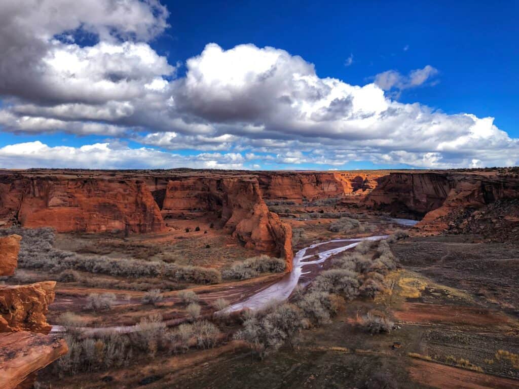
In 1931, Canyon De Chelly National Monument was recognized as a national monument to safeguard archaeological sites and artifacts. Although unaccompanied visitors are not authorized to enter the canyon, self-guided vehicle trips are available along the north and south rims.
Several crumbling cliff buildings are hidden within the canyon’s steep walls, the most striking of which is the beautiful White House Ruin. While there is extensive ancient history on display, the canyon was tragically the location of several Native American killings by the Spanish and US Armies throughout the 1800s, with the famed Long Walk beginning here.
Many of Canyon de Chelly’s major attractions may be seen from the rim roads, but a jeep or horseback trip with a Navajo guide will give you a better sense of its significance. Half-day and full-day tours take you along the rough river bottom, bringing you near to ancient ruins, caverns, and petroglyphs.
Canyon De Chelly National Monument is located 2-miles east of Chinle in Apache County, Arizona.
Organ Pipe Cactus National Monument
Located in the southwest of Arizona in Pima County, along the border to Mexico, the Organ Pipe Cactus National Monument is famous for the organ pipe cactus; it is traditionally native to Mexico. However, it is the only area in the United States where these cacti grow freely and widely due to its near location to the Mexican border.
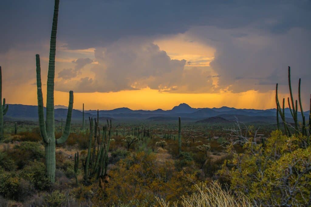
In 1937, a 517-square-mile park was established to protect a pure representation of Sonoran Desert Habitat. Organ Pipe Cactus National Monument preserves the Organ Pipe Cactus’ northernmost native habitat as well as spectacular examples of desert plants, wildlife, geology, and human history. Prepare to enjoy the trails and picturesque drives, as well as the starry nights and sunny days.
Keep yourself safe by knowing what to expect from a desert wilderness.
Chiricahua National Monument
The Chiricahua National Monument is once called by the Local Apaches ‘The Land of Standing-Up Rocks’ because of the spectacular stone spires and breathtaking balancing rocks.
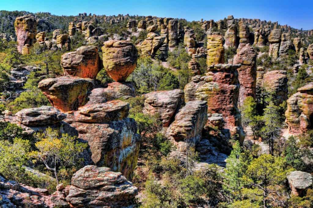
Set right in the State’s southeast corner is the captivating Chiricahua National Monument, home to some of Arizona’s most arresting and awe-inspiring landscapes; an appealing destination with mesmerizing rock formations, eight miles of magnificent views, and a 9.5-mile hike known as the “Big Loop.”
Moreover, the finest place to see wildlife is along Bonita Creek Trail, where you might spot deer, coatimundis, and a plethora of migrating birds. The restored, rough-log Stafford Cabin, located in the Faraway Ranch Historic District on the park’s east side, is open for tours on weekends and provides a fascinating—if daunting—view of pioneer life in this rugged terrain.
The Faraway Ranch historical site, a tourist center, and a campground are among the other features of this Chiricahua monument.
Vermillion Cliffs National Monument
Vermilion Cliffs National Monument lies in a very scenic, secluded setting. It’s close to the Grand Canyon and has a stunning landscape that will thrill nature lovers and outdoor enthusiasts alike.
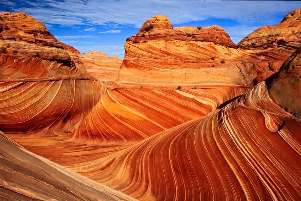
The Buckskin Gulch slot canyon, the rock formations of Coyote Buttes (including The Wave), and Lees Ferry, a tiny settlement beside the Colorado River-Paria River confluence, are all part of Vermilion Cliffs National Monument, which was established in 2000 and contains a colorful sandstone escarpment at the edge of a remote, sandy plateau.
There are few trails and no roads among the spectacular cliffs on the Utah border. They are neither inaccessible nor uninhabitable, as evidenced by the ruins and petroglyphs found throughout the plateau. Take lots of water when traveling on foot, and if you’re lucky enough to receive a permit, view the amazing Wave rock formation.
The Vermillion Cliff National Monument is located in far northern Arizona, in Coconino County just south of the Utah border
Walnut Canyon National Monument
In the 12th and 13th centuries, many Sinagua peoples lived in the 600-foot-deep Walnut Creek canyon, ten miles east of Flagstaff, where they erected multi-room houses in protected alcoves high in the canyon walls. A short but steep loop hike in the Walnut Canyon National Monument allows visitors to observe some well-preserved examples up close. A side road of Interstate 17 leads to the region.
The ruins, which originate from the 13th century, are just 10 minutes from downtown Flagstaff and are still open to the public, unlike many other national parks and monuments. Follow the walk to one of the simple pueblos at the bottom of the stairs and enter; from the window, you can see into the neighboring dwellings across the abyss. If you look down, you can be seen hundreds of feet below.
In the national monument’s museum, visitors can learn more about pre-Columbian culture and the Sinagua people themselves. Besides all the history on show, there is also the canyon and its verdant forest to explore.
Wupatki National Monument
The Wupatki National Monument, which was home to the prehistoric Pueblo people, now features the ruins of five pueblos, the largest of which were built after the adjacent Sunset Crater volcano erupted in 1085. The volcano, on the other hand, is now protected by the Sunset Crater National Monument.
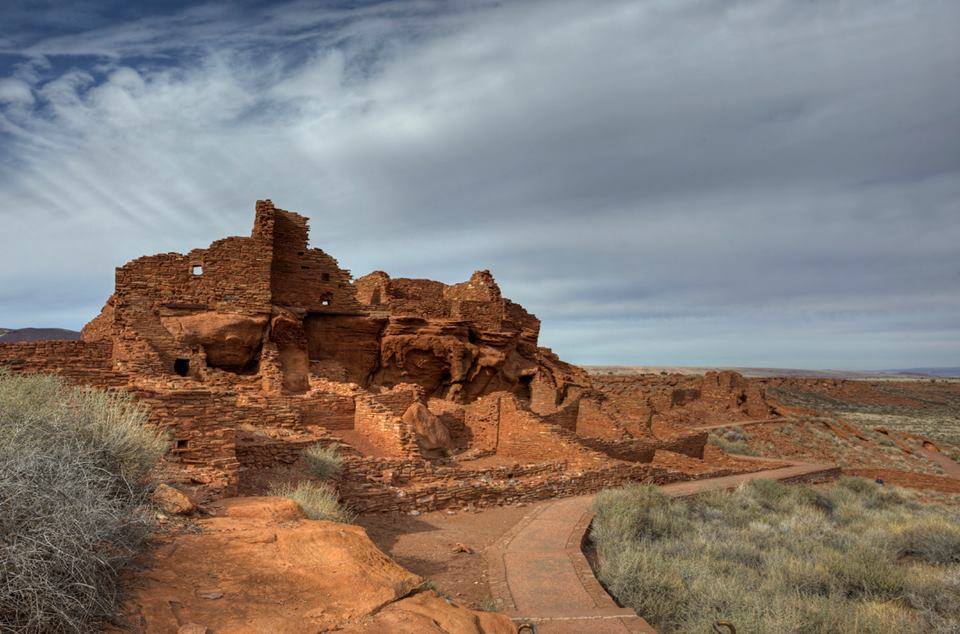
Visitors are allowed to go inside the 900-year-old Wukoki Pueblo and see the intricate adobe construction that’s stood the test of time. Don’t miss the short hike up to Citadel Pueblo, which is atop a steep hill and enjoys views across a lava-studded desert dotted with other ruins. You can also avail of trail guides from the Wupatki visitor center for a nice day trip or camp at the Sunset Crater National Monument.
Wupatki is probably the most varied and scenic of Arizona’s historical national monuments.
This national monument is located 30-miles east of Flagstaff.
Sonoran Desert National Monument
The Sonoran Desert National Monument is a rugged yet scenic preserve with a few trails and (unpaved) roads but no constructed facilities, covering half a million acres of cactus woods and isolated mountain ranges southwest of Phoenix. Interstate 8 travels across the monument, with about half of it to the north, concentrated on the Maricopa Mountains, and the other half to the south, passing through parts of the Table Top and Saguaro National Parks.
The Sonoran Desert National Monument’s primary priority is to safeguard and preserve the desert’s history. Indian antiquities, native environments, fauna, and plant species are all part of this heritage. Because of the monument’s distant position and the lack of any center, cell towers, or available water, anyone who desires to visit it should come prepared with all they may need.
The Sonoran Desert National Monument is located 55-miles Southwest of Phoenix, Arizona.
Agua Fria National Monument
The 71,000-acre Agua Fria National Monument, located 40 miles north of central Phoenix, lies adjacent to rapidly developing suburbs. The monument is made up of two mesas and the Agua Fria River canyon. The northern hills are around 4,600 feet above sea level, while the Agua Fria Canyon is roughly 2,150 feet above sea level.
In addition, the monument contains outstanding biological resources. The area is the home to coyotes, bobcats, antelope, mule deer, javelina, a variety of small mammals and songbirds including eagles and other raptors while native fish such as the longfin dace, the Gila Mountain sucker, the Gila chub, and the speckled dace, exist in the Agua Fria River and its tributaries.
Camping, bird watching, general exploration, and in particular, hiking down the canyon are just some of the activities the visitors can explore.
You can get there by traveling on Interstate 17 to the Badger Springs, Bloody Basin Road, or Cordes Junction exits.
Casa Grande Ruins National Monument
Casa Grande Ruins National Monument, located near Coolidge, Arizona, approximately northeast of Casa Grande, preserves a complex of Classic Period Hohokam ruins. This is the nation’s first archeological preserve, protects the Casa Grande and other archeological sites within its boundaries.
Prehistoric farmers inhabited much of the present-day state of Arizona for over a thousand years. When the first Europeans arrived, all that remained of this ancient culture were the ruins of villages, irrigation canals, and various artifacts. Among these ruins is the Casa Grande, or “Big House,” one of the largest and most mysterious prehistoric structures ever built in North America.
At Casa Grande Ruins, an Ancestral Sonoran Desert People’s farming community and “Great House” have been preserved. The Ruins’ allure is enhanced by the fact that the Casa Grande was either a gathering place for the Desert People or simply a waypoint marker in a vast network of canals and trading partners.
A massive, well-preserved four-story adobe structure from the Hohokam period of the fourteenth century can be seen near the desert towns of Coolidge and Casa Grande (50 miles southeast of Phoenix). An informative visitor center, a display of Sonoran Desert species, and a shady picnic area are also some of the highlights in the Ruins.
This location is also one of the hottest in the state throughout the summer.
Coronado National Monument
The Coronado National Memorial is located in a tiny section of the Coronado National Forest near the Mexican border and commemorates Francisco Vásquez de Coronado’s expedition in 1540, which was the first known European expedition into the United States.
The Park was established to commemorate and interpret the Coronado Expedition of 1540. Entered the first Europeans: the American Southwest and Northwest Mexico and irrevocably changed the lives of the indigenous people in the region.
Several hiking trails through the wooded foothills of the Huachuca Mountains, excellent views over the river valley and south into Mexico, a cave, and an interesting variety of plant and animal life are some of the sites which it offers. All could be seen in less than one day.
However, it does not get as many visitors because the area is quite isolated and not well. But there are many other hiking opportunities in the national forest to the west and north, and it is close to other historic sites like Tombstone and Bisbee.
Hohokam Pima National Monument
Located on the Gila River Indian Reservation south of Phoenix, Hohokam Pima National Monument was established in 1972 to protect the site of an ancient Hohokam village. The village was excavated but then reburied, leaving no trace. There are also no facilities at the site, and it is not open to the public.
Congress established the Hohokam Pima National Monument on October 21, 1972, to conserve an ancient Hohokam settlement known today as “Snaketown.” Excavations in the 1930s and 1960s revealed that the site was occupied from roughly 300 BC to around 1200 AD, with up to 2,000 people. Hence, 2,000 people lived in ‘Snaketown,’ a community protected by the Hohokam Pima National Monument. The site of Hokoham Pimas became inconspicuous above ground after it was excavated.
The land is protected by the reservation and not open to visitors. There is no public access to the Hohokam Pima National Monument. The Gila Indian Tribe is protecting this extremely sensitive area.
If you plan to drive along Interstate 10, you must travel and go directly through the monument. It will let you pass through the park near Mile Marker 170 where the Goodyear Road Crosses. You can also visit the Huhugam Heritage Center located in Chandler, Arizona, and the Arizona State Museum in Tucson if you desire to learn more about the Gila River Indian community.
Ironwood Forest National Monument
Located 40-miles northwest of Tucson, not far from the Saguaro National Park, the 129,000-acre Ironwood Forest National Monument, named for one of the longest-living trees in the Arizona desert, is a true Sonoran Desert showcase.
The terrain and overall vegetation are very similar to that of the surrounding Sonoran Desert National Monument, with isolated mountains divided by large, empty basins brimming with saguaro and other cactus. A working copper mine, many ancient petroglyphs, and several ghost towns are only some of the additional points of interest in the ironwood forest.
Hiking up into the mountains is the perfect way to observe more of the Ironwood Forest National Monument’s landscape, and the area around the silver mine is certainly the most interesting. Near the start of the Silver Bell Road are the remains of the village of Silver Bell – various long abandoned, ruined wooden houses now overgrown by bushes and cacti.
Hence, people often come here for solitude, primitive camping, off-trail hiking, and wildlife study.
Montezuma Castle National Monument
Established, Montezuma Castle is the third National Monument dedicated to preserving Native American culture. It was established on December 8, 1906. The monument is one of the well-preserved ancient dwellings in north-central Arizona, including the Wupatki, Tonto, Walnut Canyon, and Tuzigoot national monuments. It’s the most spectacular, with a 20-room, 5-story structure built into a 70-foot-high recess in a white limestone cliff.

Approximately 350,000 visitors visit the Castle each year to browse the museum and wander through the picturesque sycamore grove. Hundreds of native plants and animals benefit from the shade provided by the tall trees.
A picnic site near the visitor center is also visible in the area, in the shade of large sycamore trees overlooking the creek. Since 1951, climbing up the ruins has not been permitted due to the unstable condition. However, you can still walk the loop trail and take photographs which makes the visit worthwhile. Exploration away from the path is not permitted.
Located in Camp Verde, Arizona, Montezuma Castle National Monument also protects the well-preserved living spaces of the Sinagua Indians.
Navajo National Monument
At Navajo National Monument, you can explore the 800-year-old infrastructure and learn about the Navajo Nation’s cultural heritage.
Navajo National Monument preserves three large pueblos dating to the 13th-century C.E which are Betatakin, Keet Seel, and Inscription House: the three cliff dwellings at the monument. The nomadic hunter-gatherers who had lived in this area for thousands of years became more efficient at farming, began to create villages, and develop a distinct culture.
The best way to experience the cliff dwellings is the Betatakin Cliff Dwelling guided tour. It is a strenuous 5-mile trail that usually takes groups 4-5 hours to complete.
So be sure to check out the alerts page for current park notifications for the location of the Navajo National Monument offers two extreme weather conditions: below freezing from December through February and peak heat in July. Hikes may be canceled because of extreme heat in the summer or heavy snow in the winter.
Pipe Spring National Monument
Pipe Spring National Monument may be the least well-known of Arizona’s National Park Service units, owing to its remote location in the Arizona Strip’s broad, empty Antelope Valley, cut off from the rest of the state by the Grand Canyon and divided from Utah by the Vermilion Cliffs.
Pipe Spring National Monument features historic forts, gardens, and a ridge route, as well as it also serves as a water source for American Indians and Mormon ranchers. The plants, animals, and people have made it possible to live in the dry and desert region because of the water of Pipe Spring.
Now, for at least 1,000 years, Ancestral Puebloans and Kaibab Paiute Indians gathered grass seeds, hunted animals, and raised crops near the springs.
In the area, there is a visitor centre upon arrival, where visitors are encouraged to watch the detailed history of Pipe Springs. A paved pathway leads visitors around the area from the visitor’s centre, passing past several of the monument’s attractions. There is also a supplementary hiking track that offers a lovely elevated view of the monument.
Pipe Spring National Monument is located 20-miles southwest of Kanab, Arizona.
Sunset Crater Volcano National Monument
Sunset Crater Volcano National Monument lies in north-central Arizona, not far from Flagstaff. It was formed during an explosive eruption, around a thousand years ago but is now a very peaceful and pleasant place to visit.
Sunset Crater is the youngest in a string of volcanoes that make up the San Francisco Peaks, rising above the foothills and lava fields that surround it. Formerly thought to be extinct, however, its desolate and blackish slopes have been protected since 1930, when President Herbert Hoover designated it as a national monument.
The adjacent environment has been transformed by Arizona’s Sunset Crater Volcano, which today offers trekking, the scenery of flora such as Ponderosa Pines, and a variety of wildlife.
When visiting Sunset Crater Volcano, prepare for extreme weather conditions. High winds can occur year-round, with summer temperatures above 95ºF, afternoon storms July through September, and snow from fall to spring.
Tonto National Monument
Tonto National Monument contains the ruins of two cliff dwellings established by the Salado Indians around 1300 AD.
During the 13th, 14th, and early 15th centuries, the Salado civilization lived in well-preserved cliff homes. In the Salt River Valley, people farmed and supplemented their nutrition by hunting and gathering native wildlife and vegetation. The Salado were skilled artisans who created some of the finest polychrome pottery and elaborately woven textiles in the Southwest.
At its peak, the Lower Cliff Dwelling could have housed 40 to 60 people in its 20 chambers. The Upper Cliff Dwelling has roughly 40 rooms, with 32 on the ground floor and 8–10 on the second. For over a century, people resided in the Upper Dwelling. However, by 1450, the region had been abandoned.
The Tonto National Monument is located 30-miles south of Payson, Arizona.
Tuzigoot National Monument
Tuzigoot is an ancient village, or pueblo in the Verde Valley built by the Sinagua people, who were farmers and artists that preserves the ruins of Sinagua Indian homes from the 12th century. It consists of a cluster of buildings on top of a small sandstone ridge near the cities of Clarkdale and Cottonwood, close to the Verde River valley.
Tuzigoot is fascinating enough, but it’s hardly the most exciting of Arizona’s historic sites. It’s also challenging to photograph effectively. The best feature is the expansive view from the summit, which looks out over layered cliffs and ridges in all directions, as well as the lower end of Sycamore Canyon to the north and a lengthy stretch of the Verde River flowing northwest to south.
A visitor center near the entrance provides all the information you need about the ruins’ history. A loop trail, which starts and ends at the visitor center and takes visitors around the ruins as well as up the summit, is also available.
The Tuzigoot National Monument is 5 miles north of Cottonwood, Arizona.