
Tips for Visiting Death Valley in Winter
Death Valley National Park in Winter: Death Valley transforms into a desert wonderland in the winter.
Winter in Death Valley is the perfect time to visit. Visiting Death Valley in December, January, or February is the best time to see this national park.
If you are wondering where to stay near Death Valley National Park you can check out my post on Death Valley Airbnbs and Death Valley Glamping. You can also check out my post on How to Spend One Day in Death Valley.
Weather in Death Valley in Winter
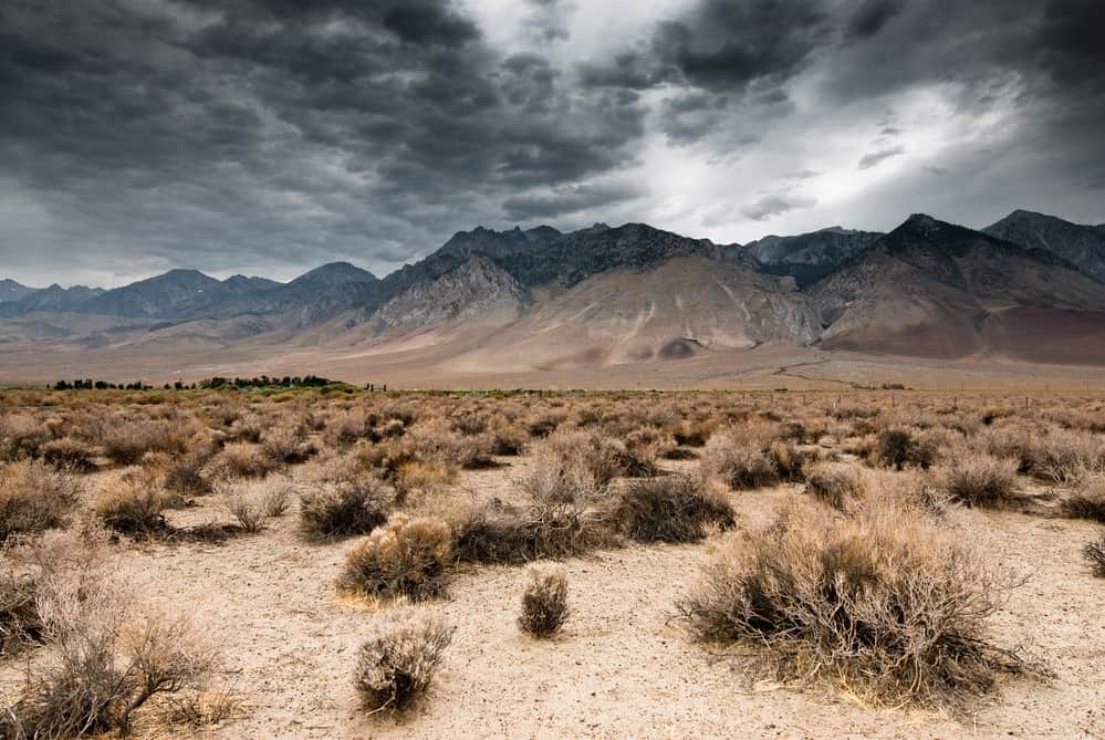
Temperatures in the winter range from the mid-60s to the low 70s, with overnight lows regularly falling into the upper 30s. The average temperature is 67F in winter.
Winter is the ideal time to visit Death Valley National Park because of the cooler temperatures and clear, sunny days. There is virtually no rain in the Death Valley over winter.
You can be basking in warm, dry days with the endless sun when the rest of the country is shivering. You can hike without breaking a sweat after 5 seconds, and there’s no need to be concerned about rain since Death Valley rarely rains, even in the winter.
Hiking in Winter in Death Valley
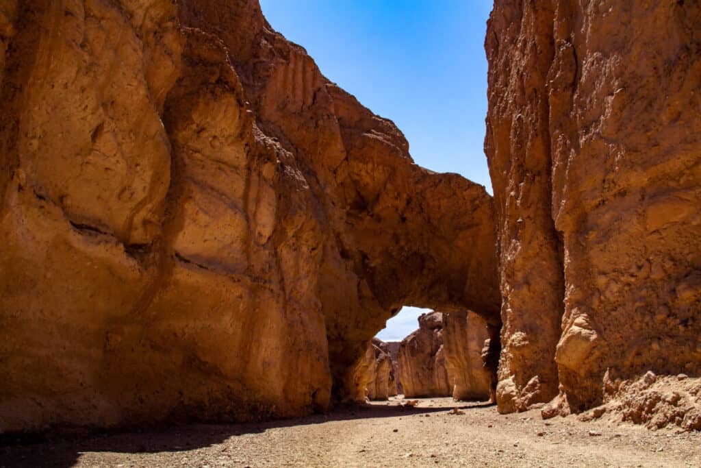
Winter weather is also ideal for hiking trails into the park’s canyons and viewing its unique geology. Along Badwater Road, you’ll find easy-to-reach trailheads, including the renowned Golden Canyon hike, which is only five minutes away. However, many visitors overlook the neighboring Desolation Canyon hike, which is far less busy. It’s a simple cross-country trail that leads into a canyon that gradually narrows and leads to multicolored rocks reminiscent of the Artist’s Palette.
Things to do in Death Valley in Winter
Take a Drive in Death Valley
There are various driving routes across Death Valley, and it is a fantastic way to spend a winter day in the park. Highway 190, which enters the park via Highway 395 from California, and Highway 160, which enters the park via Highway 190 from the south end of Las Vegas, are two significant highways that enter the park.
Dante’s View, Twenty Mule Canyon, Zabriskie Point, and others are among the many vistas along Highway 190’s driving route. From Furnace Creek to Badwater, you can continue south and stop at various vistas along the way, including Desolation Canyon, Artist’s Drive, Devil’s Natural Bridge, and Devil’s Golf Course.
Zabriskie Point Trail
You’ll pass Zabriskie Point on your way into the valley from Highway 190. Zabriskie Point is located on the Park’s east side, nearly opposite Father Crowley Point.

Wiki Commons
King of Hearts
The Furnace Creek formations can be seen from a viewpoint near the road, and the stark badlands landscape is easily visible in broad sunshine. You can hike down into the area or start the hike near Badlands Loop if you like. Golden Canyon, Gower Gulch, and Red Cathedral are all accessible through connecting trails.
The best part about this place is the multicolored rocks and how the sun makes them appear to be on fire. Even if you can’t see the valley, you still have a unique vista because the hues of the more immediate Zabriskie rock formations contrast sharply with the Panamint Mountains in the distance.
Although the hike is paved and presents no technical problems, it is uphill and in direct sunlight. There is also a 2.7-mile loop departing from the viewpoint that takes you close to the rock formations if you want to go deeper into the Badlands at Zabriskie Point. Remember to bring your water bottle!
Ubehebe Crater
Ubehebe Crater is near the Eureka Dunes and Scotty’s Castle in Death Valley National Park’s north end. Three trails and a parking lot near the rim provide even better views of the crater.
The magnificent Ubehebe Crater is a monument to Death Valley’s violent volcanic past. Ubehebe is the largest of a series of craters that pockmark the landscape, measuring 600 feet deep and half a mile across.
Explore numerous smaller, more eroded craters by walking along the rim of the crater’s loop trail. Observe the huge blanket of grey-black cinder left by Ubehebe’s eruption from the rim’s high point.
Taking the short but steep trail to the bottom of the crater is another excellent opportunity to appreciate the vastness of Ubehebe. The 600 feet of elevation gain on the way back up may not seem like much, but it might seem like twice that when hiking up the steep, loose cinder trail. Ubehebe Crater is a great place for hikers of all ages and abilities.
Badwater Basin Crossing
Badwater Basin is a well-known attraction in Death Valley that you should not miss. At 277 feet below sea level, it is also the lowest point on land in the Western Hemisphere.
If you’re willing to walk a mile or so from the parking lot in the winter, you’ll be able to view it with a tiny bit of water in it. And, if there’s water, the Amargosa Mountains to the east can be seen in a stunning reflection.
If you walk out into the flats, you’ll be able to see the rain and evaporation process, which results in a pattern of rough hexagonal salt ridges. A fascinating process that you can’t fully appreciate unless you visit in the winter.
The path begins at the Badwater Road parking lot, and the first mile or so is well-traveled, as here is where the majority of hikers begin. After that, the trail becomes narrower and less visible until it vanishes entirely.
Dante’s View
Dante’s View is approximately about a half-hour drive from the east entrance. Dante’s View, a viewpoint on a mountainside at 5,476 ft (1,669 m) overlooking Death Valley, is the best site to start your Death Valley in winter adventure with a bang.

Wiki Commons Mikenorton
It’s the perfect location for a panoramic view of Death Valley National Park, with the entire depression in front of you flanked by mountains. In addition, you can also see Devil’s Golf Course.
Early morning is the best time to visit Dante’s View to witness the sunrise. You’ll want to arrive early to see the sunrise over Telescope Peak on the other side of the valley before descending the Panamint Mountains and crossing the basin. It becomes windy and chilly up there, so dress warmly in gloves and something to shield you from the wind.
Devil’s Golf Course
The salt flats in Death Valley’s Badwater Basin are minerals that remained after Lake Manly evaporated around 10,000 years ago. Devils Golf Course is the area’s largest example of this phenomenon, having been formed by wind and rain.

Wiki Commons Supercarwaar
The landscape is dominated by these halite salt crystal formations, which resemble hard, jagged rocks. Although it is safe to bring around the golf course, it is not advised because the ground is uneven and sharp, making visitors vulnerable to cuts, twisted ankles, and broken bones. This salt flat takes its name from a 1934 National Park Service manual that says “On such a course, only the Devil could play golf.”
Devils Golf Course is a short drive down Badwater Road and onto a rocky access road that leads to the middle of the salt flat from the Furnace Creek Area. Devils Golf Course is accessible by driving, although an SUV or off-road vehicle is recommended. The road comes to a halt in a small parking lot with a capacity for around a dozen vehicles. There are no trails that lead farther into the Golf Course, although they aren’t necessary.
The views from this vantage point are spectacular. The Panamint Mountains tower above you, providing a stunning background for the eerie “golf course.” In this area, there are no restrooms or water. Leashed dogs are permitted; however, they are not advised.
Artists Palette
The Artist’s Drive is a colorful one-way road that loops out from Badwater Rd. This narrow road is enjoyable to drive because it rises and descends small hills and curves sharply.

Wiki Commons Tuxyso
The hues on the rock formations around you are the best part of Artists Drive. There is a parking spot along the drive where you can see what is known as the Artists Palette.
The pink granite swirls of this spectacular rock formation seem to shimmer in the dusk, making it well worth a visit. There’s a lot to see in Death Valley at sunset, so plan on staying a few nights and making sure you see one of them at Artist’s Palette.
Remember that it’s a one-way street, so you’ll have to drive it from south to north, which will need a slight detour if you’re coming from Devil’s Golf Course. The distance between Devil’s Golf Course and Artists Palette is approximately 15 miles, including the lovely drive!
Mesquite Flat Sand Dunes
The Mesquite Sand Dunes, which rise about 100 feet in height and are known for their sand-boarding potential, are another prominent attraction in the US national park.
Wiki Commons Tuxyso
While there is no special established trail due to continuous sand movements, walking across the dunes is worthwhile and one of the best things to do in Death Valley in the winter. You can also go straight up to the highest dunes to get a good view of the surrounding area.
Since there are no paths into the dunes, getting to the more pristine and higher dunes will require a half-hour walk through the deep sand. It’s a good workout, particularly when climbing the higher dunes. However, the further back you go, the fewer other hikers’ footprints you’ll find. There are hardly any back to the top of the last dunes.
You can also take fantastic photos of sunrises and sunsets, as the light at these moments properly adorns and ornaments the area’s magnificence! The incoming light creates ripples and patterns on the sand during sunsets.
The Mesquite Sand Dunes are a must-see site in Death Valley National Park and are located directly alongside the main road.
Eureka Dunes
The Eureka Dunes, a glittering mountain of sand flanked by the rugged dark mountains of the Last Chance Range, rise from the Eureka Valley floor, isolated, gorgeous, and pristine. The Eureka Dunes are the tallest sand dunes in California, soaring more than 680 feet above the confined valley floor. They are three miles broad and one mile long. Everything appears to be stripped down to its most basic yet breathtaking parts at the Eureka Dunes.
It’s difficult to resist the urge to climb the sand dunes. A trip into the dunes from the Eureka Dunes Dry Camp at the base of the dunes can take anything from 0.5 to 2.5 miles, depending on how far you walk. The ascent is hard, with one stride forward followed by a slide back. Depending on whatever ridge you tackle, you may be ascending 300 to 600 feet. You’ll be rewarded with more sculpted dunes and expansive vistas of the valley once you reach the crest.
A little rumbling sound may break the silence in all this silent sand and desert. The Eureka Dunes are singing dunes, and little avalanches of sand produce a powerful booming sound now and then. Then there’s the possibility that fighter planes from Nellis Air Force Base, located to the east, will be out displaying their skills.
Ibex Dunes
Ibex Dunes are perhaps the most photogenic and remote dunes in the park. These dunes may be found on the park’s southern edge, off of a rough, high-clearance road. These dunes are fun to explore but get there early because they heat up quickly, even in the winter, and can put hikers in danger.
Finding the abandoned mine on the further side of the dune, set against the mountains, is one of the most exciting elements of exploring Ibex Dunes. This eerie location is a relic from the park’s past and offers a great photo opportunity.
Since there is no shade in or around the dunes, bring plenty of water as well as sunscreen. If you want to visit Ibex Dunes, you’ll need a high-clearance vehicle because the drive into the dunes is rough.
Wildrose Charcoal Kilns
The Wildrose Charcoal Kilns, which were built in 1876, is a famous tourist site in Death Valley, California. It was established to provide fuel for the processing of silver and lead ore from George Hearst’s Modock Consolidated Mining Company, which operated from 1878.
The Wildrose Charcoal Kilns’ bee-shaped structures are a popular tourist destination and are among the best preserved in the western United States. Once you’re inside, you can even smell the smoke!
This is located near Panamint Springs in Upper Wildrose Canyon. The trip to the location is a little tedious but will be worth your time and effort.
Twenty Mule Canyon
The rich mining history of Death Valley National Park is well-known. The Twenty Mule teams and wagons that previously hauled tons of borax through this rugged terrain have left an indelible mark. Around the turn of the century, Twenty Mule Team Canyon was actively prospected for borax, leaving behind a plethora of loading platforms, mining tailings, and tunnels.
The picturesque journey down this amazing canyon leads to a plethora of hiking opportunities in the Black Mountains’ brightly colored badlands. Along the way, you can choose from a variety of small hikes across canyons and ridges. There are no designated trails, so pick your adventure carefully. The badland hills along this journey are brimming with opportunities for exploration.
To get to Twenty Mule Team Canyon, take Highway 190 southeast from Furnace Creek for 5 miles (One mile past Zabriskie Point). Twenty Mule Team Canyon is indicated by a road sign to the west (right). Here is where you should turn and begin your journey. Twenty Mule Team Canyon Road leads back to Highway 190 after 2.8 miles.
Take this trip early in the morning or late in the afternoon for a spectacular show of light and shadow.
Inn at Furnace Creek
The Pacific Coast Borax Company of the Twenty Mule Team established the Inn at Furnace Creek as a way to save their recently built Death Valley Railroad, which has been a member of Historic Hotels of America since 2012. The Inn was built in 1927 and designed by notable Los Angeles architects Albert C Martin and Daniel Hull.
The Inn has been an elegant getaway for almost 85 years and is listed on the National Register of Historic Places. Guests can enjoy great cuisine in one of the world’s most remote locations, relax in the spring-fed pool, stroll through magnificent palm gardens, or shop for unique items in the gift shop or neighboring General Store. The architecturally gorgeous Inn also has a one-of-a-kind function space that is excellent for small business meetings and social events.
Tennis, sports courts, horseback riding, and romantic carriage rides are all available during the winter season. At 214 feet below sea level, guests can play golf on the world’s lowest golf course. The nine-hole course was opened in 1931, then in the fall of 1968, it was enlarged to 18 holes. In 1997, acclaimed golf course architect Perry Dye renovated the course and included a high-tech irrigation system. The resort’s spring-fed swimming pools are used to irrigate the course.
Golden Canyon
Some of the best hiking in Death Valley National Park can be found on this trail through the Golden Canyon and the Zabriske Point badlands. The trail starts at the Golden Canyon Trailhead, which is located just 3.5 miles south of the Furnace Creek Visitor Center on Badwater Road. Golden Canyon has an interpretive trail guide available at the trailhead information kiosk.
The canyon is carved through golden yellow sediments that were deposited at the bottom of Lake Manly about 5 million years ago. The various color bands on the walls indicate the presence of various minerals.
For the first mile of the hike, the trail gently ascends the canyon. The Red Cathedral Access on the Upper Golden Canyon Trail can be used to enjoy close-up views of the Red Cathedral, which stands above Golden Canyon. At 1.5 miles, the path meets Gower Gulch for the first time, where the Gower Gulch Circle Connector trail offers for a shorter loop trip to Gower Gulch.
Return to the Golden Canyon Trailhead via the Gower Gulch Trail. Continue on to Zabriske Point by following the signs. The trail will eventually arrive at Zabriske Point, where the paved Zabriskie Point Access Trail provides a great perspective of the canyons and badlands you have traversed.
Salt Creek Interpretive Trail
Most people don’t expect to find animals living nearly 150 feet below sea level, where temperatures can reach 100 degrees by mid-morning and water salinity is higher than the ocean. Yet, when you explore the Salt Creek Interpretive Trail, you might be shocked by what you find.
Death Valley National Park’s severe salt marsh environment provides a habitat for a diverse range of plants and fauna. The Salt Creek Pupfish is a unique species found nowhere else in the world. It tells the story of environmental change and how an animal adapts to it. Death Valley was once a land of vast lakes and marshes during the last Ice Age, roughly 15,000 years ago. The geology and environment have changed over time, and the pupfish’s life has changed as well.
This short, ADA-accessible loop walk offers a great opportunity to see wildlife, including the endangered pupfish. Along the trail, interpretive markers detail the various flora and animals that can be found in this unique desert environment. A few benches are also strewn throughout the boardwalk.
Stay on the boardwalk to help conserve the fragile ecology. Dogs are also prohibited.